IMAGES TAKEN NEAR TO
Cove, HELENSBURGH, G84 0NZ
Introduction
This page details the photographs taken nearby to G84 0NZ by members of the Geograph project.
The Geograph project started in 2005 with the aim of publishing, organising and preserving representative images for every square kilometre of Great Britain, Ireland and the Isle of Man.

There are currently over 7.5m images from over14,400 individuals and you can help contribute to the project by visiting https://www.geograph.org.uk
Image Map
Images are licensed for reuse under creativecommons.org/licenses/by-sa/2.0
Notes
- Clicking on the map will re-center to the selected point.
- The higher the marker number, the further away the image location is from the centre of the postcode.
Image Listing (5 Images Found)
Images are licensed for reuse under creativecommons.org/licenses/by-sa/2.0
Image
Details
Distance
2
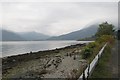
A view north at Loch Long
From the B833 near Letter south of Cooulport.
Image: © James Denham
Taken: 18 Sep 2014
0.05 miles
4
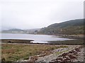
Peaton Layo Looking North
The view from Peaton Layo towards a small hamlet at Coulport.
Image: © James T M Towill
Taken: 14 Oct 2009
0.20 miles
5
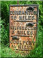
Old Milepost by the B833, Shore Road, Coulport, Rosneath Parish
Dunbarton plate by the B833, in parish of Rosneath (Argyll and Bute District), Coulport, near 'SLOW' on road and MOD sign, East side of road.
Inscription reads:- : {pointing hand} / DUNBARTON / 29 MILES. / {pointing hand} / KILCREGGAN / 5 MILES. / {pointing hand} / COULPORT ½ MILE. :
Surveyed
Milestone Society National ID: AB_GLCP13
Image: © Milestone Society
Taken: 1 Jan 2009
0.21 miles