IMAGES TAKEN NEAR TO
Church Road, HELENSBURGH, G84 0LZ
Introduction
This page details the photographs taken nearby to Church Road, G84 0LZ by members of the Geograph project.
The Geograph project started in 2005 with the aim of publishing, organising and preserving representative images for every square kilometre of Great Britain, Ireland and the Isle of Man.

There are currently over 7.5m images from over14,400 individuals and you can help contribute to the project by visiting https://www.geograph.org.uk
Image Map
Images are licensed for reuse under creativecommons.org/licenses/by-sa/2.0
Notes
- Clicking on the map will re-center to the selected point.
- The higher the marker number, the further away the image location is from the centre of the postcode.
Image Listing (69 Images Found)
Images are licensed for reuse under creativecommons.org/licenses/by-sa/2.0
Image
Details
Distance
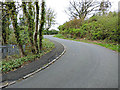
1
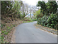
Church Road
Looking down the hill to the double bend.
Image: © Thomas Nugent
Taken: 27 Apr 2015
0.03 miles
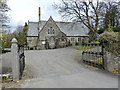
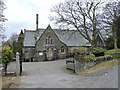
2
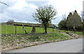
Playing field
At the top of Church Road.
Image: © Thomas Nugent
Taken: 27 Apr 2015
0.03 miles
3
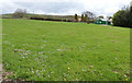
Playing field
At the top of Church Road. The building on the right is a "Youth Cafe".
Image: © Thomas Nugent
Taken: 27 Apr 2015
0.03 miles
4
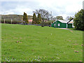
Playing field
At the top of Church Road. The building on the right is a "Youth Cafe".
Image: © Thomas Nugent
Taken: 27 Apr 2015
0.03 miles
5
Church Road
Looking up the hill to the double bend.
Image: © Thomas Nugent
Taken: 27 Apr 2015
0.03 miles
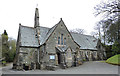
7
Craigrownie Parish Church
At the top of Church Road.
Image: © Thomas Nugent
Taken: 27 Apr 2015
0.03 miles
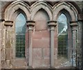
8
Craigrownie Parish Church
At the top of Church Road.
Image: © Thomas Nugent
Taken: 27 Apr 2015
0.03 miles
10
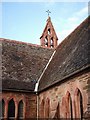
Two Little Bells
Bell tower at Craigrownie Church, Cove
Image: © Lynn M Reid
Taken: 8 Apr 2008
0.04 miles