IMAGES TAKEN NEAR TO
Willhouston Drive, G84 0LJ
Introduction
This page details the photographs taken nearby to Willhouston Drive, G84 0LJ by members of the Geograph project.
The Geograph project started in 2005 with the aim of publishing, organising and preserving representative images for every square kilometre of Great Britain, Ireland and the Isle of Man.

There are currently over 7.5m images from over14,400 individuals and you can help contribute to the project by visiting https://www.geograph.org.uk
Image Map
Images are licensed for reuse under creativecommons.org/licenses/by-sa/2.0
Notes
- Clicking on the map will re-center to the selected point.
- The higher the marker number, the further away the image location is from the centre of the postcode.
Image Listing (24 Images Found)
Images are licensed for reuse under creativecommons.org/licenses/by-sa/2.0
Image
Details
Distance
1
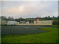
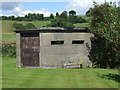
Ensign Motifs
Ensign Motifs, a supplier of a range of products emblazoned with motifs for promotional purposes, is based above Portkil Bay.
Image: © Mark Nightingale
Taken: 31 Dec 2010
0.05 miles
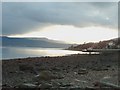
2
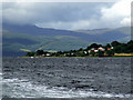
Portkill Point
On the Rosneath Peninsula. Viewed from the ferry just left Kilcreggan for Helensburgh.
Image: © Thomas Nugent
Taken: 21 Aug 2010
0.06 miles
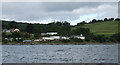
4
Portkill Point
Viewed from the ferry on the way to Helensburgh.
Image: © Thomas Nugent
Taken: 21 Aug 2010
0.11 miles
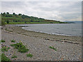
6
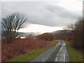
Pill box, Portkil
A good track/path runs round Portkil Bay.
Image: © wfmillar
Taken: 21 May 2008
0.11 miles
7
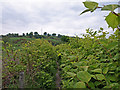
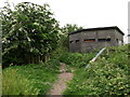
Path, Portkil
Almost overgrown. Gallow Hill has the mast.
Image: © wfmillar
Taken: 21 May 2008
0.13 miles