IMAGES TAKEN NEAR TO
Argyll Road, HELENSBURGH, G84 0JY
Introduction
This page details the photographs taken nearby to Argyll Road, G84 0JY by members of the Geograph project.
The Geograph project started in 2005 with the aim of publishing, organising and preserving representative images for every square kilometre of Great Britain, Ireland and the Isle of Man.

There are currently over 7.5m images from over14,400 individuals and you can help contribute to the project by visiting https://www.geograph.org.uk
Image Map
Images are licensed for reuse under creativecommons.org/licenses/by-sa/2.0
Notes
- Clicking on the map will re-center to the selected point.
- The higher the marker number, the further away the image location is from the centre of the postcode.
Image Listing (71 Images Found)
Images are licensed for reuse under creativecommons.org/licenses/by-sa/2.0
Image
Details
Distance
1
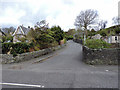
Donaldson's Brae
Off the B833 Rosneath Road/Shore Road.
Image: © Thomas Nugent
Taken: 27 Apr 2015
0.13 miles
2
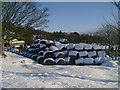
Hay bales at Little Aiden Farm
Hay bales protected from an early snowfall at Little Aiden Farm in Kilcreggan.
Image: © Mark Nightingale
Taken: 2 Dec 2010
0.14 miles
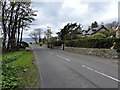
3
Rosneath Road, Kilcreggan
Looking towards Donaldson's Brae, where this road (the B833) becomes Shore Road.
Image: © Thomas Nugent
Taken: 27 Apr 2015
0.15 miles
4
Shore Road
The B833 from Kilcreggan to Cove and Coulport.
Image: © Thomas Nugent
Taken: 27 Apr 2015
0.15 miles
5
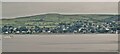
Kilcreggan from Kempock Point, Gourock
Image: © Chris Morgan
Taken: 20 Jun 2021
0.16 miles
6
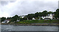
Kilcreggan from the Clyde
Viewed from the ferry which has just left for Helensburgh.
Image: © Thomas Nugent
Taken: 21 Aug 2010
0.17 miles
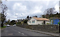
7
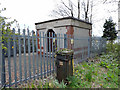
Electrical sub-station
On Shore Road, near Donaldson's Brae.
Image: © Thomas Nugent
Taken: 27 Apr 2015
0.17 miles
8
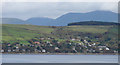
Firth of Clyde and Kilcreggan
Viewed from Turnberry Avenue in Gourock.
Image: © Thomas Nugent
Taken: 6 Jun 2011
0.18 miles
9
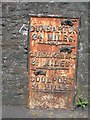
Old Milestone by the B833, Kilcreggan, Rosneath Parish
Dunbarton plate by the B833, in parish of Rosneath (Argyll and Bute District), Kilcreggan, on bend opposite the iron railings, against stone wall, North side of road.
Inscription reads:- : {pointing hand} / DUNBARTON / 21 MILES / {pointing hand} / GARELOCHHEAD / 8½ MILES / {pointing hand} / COULPORT / 5½ MILES :
Surveyed
Milestone Society National ID: AB_GLCP08
Image: © Milestone Society
Taken: Unknown
0.18 miles
10
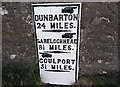
Old Milestone by the B833, Kilcreggan, Rosneath Parish
Dunbarton plate by the B833, in parish of Rosneath (Argyll and Bute District), Kilcreggan, on bend opposite the iron railings, against stone wall, North side of road.
Inscription reads:- : {pointing hand} / DUNBARTON / 21 MILES / {pointing hand} / GARELOCHHEAD / 8½ MILES / {pointing hand} / COULPORT / 5½ MILES :
Milestone Society National ID: AB_GLCP08
Image: © Mel Towler
Taken: 29 Jul 2023
0.18 miles