IMAGES TAKEN NEAR TO
Burnside, HELENSBURGH, G84 0EA
Introduction
This page details the photographs taken nearby to Burnside, G84 0EA by members of the Geograph project.
The Geograph project started in 2005 with the aim of publishing, organising and preserving representative images for every square kilometre of Great Britain, Ireland and the Isle of Man.

There are currently over 7.5m images from over14,400 individuals and you can help contribute to the project by visiting https://www.geograph.org.uk
Image Map
Images are licensed for reuse under creativecommons.org/licenses/by-sa/2.0
Notes
- Clicking on the map will re-center to the selected point.
- The higher the marker number, the further away the image location is from the centre of the postcode.
Image Listing (17 Images Found)
Images are licensed for reuse under creativecommons.org/licenses/by-sa/2.0
Image
Details
Distance
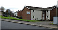
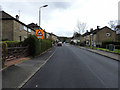
1
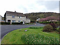
Linn Walk
Off the roundabout at Feorlin Way.
Image: © Thomas Nugent
Taken: 27 Apr 2015
0.03 miles
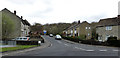
2
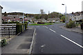
Feorlin Way
Looking towards the roundabout at Linn Walk.
Image: © Thomas Nugent
Taken: 27 Apr 2015
0.03 miles
4
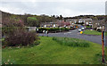
Feorlin Way
At the roundabout at Linn Walk.
Image: © Thomas Nugent
Taken: 27 Apr 2015
0.06 miles
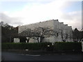
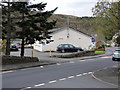
5
Garelochhead Medical Centre & The Oasis
On Feorlin Way.
Image: © Thomas Nugent
Taken: 27 Apr 2015
0.06 miles
6
Linn Walk
Off the roundabout at Feorlin Way.
Image: © Thomas Nugent
Taken: 27 Apr 2015
0.07 miles
7
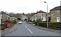
Queens Crescent
The north end of the road at Feorlin Way.
Image: © Thomas Nugent
Taken: 27 Apr 2015
0.07 miles
8
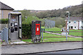
Phone box and postbox
On Feorlin Way, near the police station.
Image: © Thomas Nugent
Taken: 27 Apr 2015
0.10 miles
9
Feorlin Way
Looking towards the police station from Queens Crescent.
Image: © Thomas Nugent
Taken: 27 Apr 2015
0.12 miles
10
Garelochhead police station
On Feorlin Way at Queens Crescent.
Image: © Thomas Nugent
Taken: 27 Apr 2015
0.13 miles