IMAGES TAKEN NEAR TO
George Street, ALEXANDRIA, G83 9JF
Introduction
This page details the photographs taken nearby to George Street, G83 9JF by members of the Geograph project.
The Geograph project started in 2005 with the aim of publishing, organising and preserving representative images for every square kilometre of Great Britain, Ireland and the Isle of Man.

There are currently over 7.5m images from over14,400 individuals and you can help contribute to the project by visiting https://www.geograph.org.uk
Image Map (Loading...)


Getting Data...Please wait
Leaflet Map data © OpenStreetMap
Images are licensed for reuse under creativecommons.org/licenses/by-sa/2.0
Notes
- Clicking on the map will re-center to the selected point.
- The higher the marker number, the further away the image location is from the centre of the postcode.
Image Listing (108 Images Found)
Images are licensed for reuse under creativecommons.org/licenses/by-sa/2.0
Image
Details
Distance
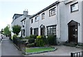
1
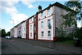
86 George Street, Bonhill
"Christie Building" Two Storey Red Sandstone property in George Street, Bonhill, Alexandria built in 1894
Image: © George Rankin
Taken: 6 Aug 2019
0.01 miles
2
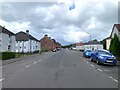
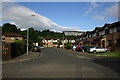
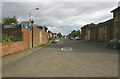
George Street, Bonhill
George Street, Bonhill, Alexandria, looking north towards Ben Lomond. New council estates were built in both George Street and Hillbank in the 1920's, on what were green field sites. The George Street houses were built on the remaining part of the old Ladyton Park.
Image: © George Rankin
Taken: 6 Aug 2019
0.03 miles
3
George Street Lane. Bonhill.
View of George Street Lane, Bonhill from George Street looking east.
Image: © George Rankin
Taken: 25 Jun 2007
0.03 miles
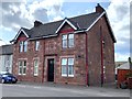
4
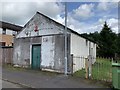
The Wee Hut
"The Wee Hut" Finlayson's in George Street, which like a few other small shops started out as a wooden hut. It passed on to George street resident Gertie Mooney and in the 50's it was sold to Johnnie Allen and later to another George Street resident, George McGinty. For a short period of time 1975 the local V.O.L. Cooperative Soc. ran the shop, until it was taken over as a storage area for various groups.
Image: © George Rankin
Taken: 6 Aug 2019
0.05 miles
5
Springcroft Grove Bonhill
View of Springcroft Grove, Bonhill from George Street this development is built on the site of the former McDougall's Lemonade Factory which produced lemonade from a local spring.
Image: © George Rankin
Taken: 25 Jun 2007
0.06 miles
6
Raglan Street Lane Bonhill
View of Raglan Street Lane, Bonhill from George Street looking East.
Image: © George Rankin
Taken: 25 Jun 2007
0.06 miles
7
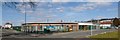
Bonhill Primary School
The picture was taken during the school holidays, when the school was not in use. This new building stands at the corner of Main Street and Raglan Street; it replaces a red sandstone building, which opened in 1874, and which stood directly across the Main Street from this site: Image
Image: © Lairich Rig
Taken: 5 Apr 2013
0.06 miles
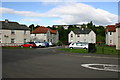
9
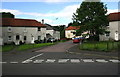
George Street Bonhill
View of George Street Bonhill looking South. On the left can be seen Bonhill Veterans Bowling Club
Image: © George Rankin
Taken: 25 Jun 2007
0.08 miles