IMAGES TAKEN NEAR TO
Burn Street, ALEXANDRIA, G83 9AN
Introduction
This page details the photographs taken nearby to Burn Street, G83 9AN by members of the Geograph project.
The Geograph project started in 2005 with the aim of publishing, organising and preserving representative images for every square kilometre of Great Britain, Ireland and the Isle of Man.

There are currently over 7.5m images from over14,400 individuals and you can help contribute to the project by visiting https://www.geograph.org.uk
Image Map
Images are licensed for reuse under creativecommons.org/licenses/by-sa/2.0
Notes
- Clicking on the map will re-center to the selected point.
- The higher the marker number, the further away the image location is from the centre of the postcode.
Image Listing (132 Images Found)
Images are licensed for reuse under creativecommons.org/licenses/by-sa/2.0
Image
Details
Distance
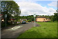
1
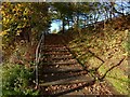
Steps leading to Stirling Road
Two lower flights of steps, one leading from Main Street, Bonhill, the other from the corner of George Street and Campbell Street, lead directly to the foot of the flight shown here.
Image: © Lairich Rig
Taken: 29 Oct 2017
0.02 miles
2
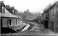
Old Burn Street
This is a view of Burn Street, Bonhill in the late 1800's, the open burn came from the Pappert hills behind Bonhill and ran down the side of the Quarry which lay just behind these houses. The burn was later covered over and runs into the river Leven. Nowadays only one or two modern houses survive this scene.
Image: © George Rankin
Taken: Unknown
0.02 miles
3
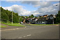
Burn Street Bonhill
View of present day Burn Street, Bonhill. Compare this with the view of Old Burn Street which is also on this web page.
Image: © George Rankin
Taken: 25 Jun 2007
0.03 miles
4
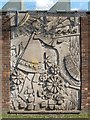
The Braes o' Bonull (stone relief)
This artwork can be found in Bonhill, on the outside wall of the Veterans Bowling Club in Image (it can be seen, left of centre, on the wall in that photograph).
Although there is no explanation accompanying the artwork, a friend of mine happened to know its significance, and, when we were both in that street, he was able to point me in the right direction: the artwork represents the chorus of an old song called "The Braes o' Bonull" [i.e. Bonhill], whose complete words can be found at http://www.valeofleven.org.uk/valesongsandpoems.html
All of the elements mentioned in the chorus appear in the artwork; even the bull is visible in the background, at the upper right. As for the whole song, the sole obscure reference in it is to "The Slunger": this was the name of a local road, now long gone, whose course more or less corresponded with that of the modern Northfield Road; see the following, under the heading "Slunger": http://www.valeofleven.org.uk/scottishplacenames/Svale_names.html
Northfield Road, mentioned above, begins to the north of the location shown in the photo, on the other side of Main Street (which is shown in red on the map), as a continuation of Hillbank Street; it runs NNE past the club house of a golf course. The road was once called Slunger Hill Road, a name that is connected to the textile industry that was once prominent in that area, as I learned from an exhibition on that industry: according to an information panel that was part of that exhibition, to "slunge" or "slounge" meant, in Old Scots (see https://dsl.ac.uk/results/slunge at the DoSL), to "souse with water", and it was an activity that was carried out in the local bleachfields. The information panel may or may not be correct in this assertion, and alternative explanations for the name "Slunger" have been suggested (see the link at the end of the previous paragraph).
The 1912 book "Records and Reminiscences of Bonhill Parish" (by John Neill) variously calls it "Slunger Hill Road" (p91), "The Slunger Road", or just "The Slunger" (these last two forms are found on p173). The book also notes several other local names for places in the vicinity, making it a very useful record.
Incidentally, the use of that hillside area as a bleachfield is recorded in the same book. Page 15 discusses the Dalmonach Works, pointing out that although an entrance to the works was located at "the site on which Dalmonach School was built" (see Image), the gate of the works had at an earlier period been at the so-called Cannon Row. With reference to that earlier works entrance, the book says that "nearly opposite to the old gate was a road leading up through the farm lands, on to the 'Hilton Braes', where, before the days of 'Chemical Bleaching', the cloth in its grey state was carted, and by exposure to all weathers, bleached white".
The place-name 'Hilton Braes' is unfamiliar today, but that reference is cleared up by page 7 of the same book: "there was also a road on the east side of the village [of Bonhill] passing Hillton, now known as Hillbank. This road was called the High Road, and the more public highway was known as the Low Road". The name Hillbank is preserved to this day in Hillbank Street, of which Northfield Road (the Slunger) is the more northerly continuation. The first-edition OS map, surveyed in 1860, shows "Hillbank" adjacent to "Hilltown of Napierston" (clearly the origin of "Hillton"/"Hilton Braes"), so, if not identical, these places are at least in the same general area.
Note that "Bonull", as used in the song, is not a corruption of the present-day form "Bonhill", as might be thought. It is, in fact, an older form of the same place-name; the name Bonhill does not really refer to a hill. Other old spellings ("Bullul" and "Buchnul") are preserved in charters of the Earls of Lennox, while the Atlas of Scotland (as mapped by Timothy Pont in the 1580s and 1590s, but published by Joan Blaeu in 1654) shows the "Kirk of Binnuill".
[Simon Taylor, in his chapter of the book "Changing Identities, Ancient Roots", discusses the name Bonhill, which "if not British, may show British influence". He cites some early (13th century) forms of the parish name: Buthelulle and Bohtlul. He analyses these as "Both" (meaning "church", at least in this context), and a name, possibly the "Saint Lolanus" who was venerated at Kincardine, Perthshire, or perhaps another saint of the same name. See the book for the full details.]
Image: © Lairich Rig
Taken: 22 Sep 2008
0.05 miles
5
Campbell Street Bonhill
View of Campbell Street in Bonhill from Main Street looking east.
Image: © George Rankin
Taken: 25 Jun 2007
0.05 miles
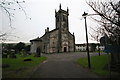
6

E. A. McCarroll and Rossi's Hot Food Take-away
Car sales, servicing and repairs and the Bonhill Fish and Chicken Bar. Bonhill Old Parish Church is behind.
Image: © Richard Sutcliffe
Taken: 11 May 2019
0.07 miles
8
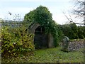
Mausoleum of the Martins of Auchendennan
The mausoleum is better seen in another contributor's picture: Image It is located beside a driveway leading to Image (The stone on the right is not related to it, but is for "William Ewing, native of Vale of Leven, graduate of Glasgow University, for fifty years resident of the southern states of America, etc".)
The lands of Auchendennan were subdivided into Auchendennan-Dennistoun, Auchendennan-Rhie, and Auchendennan-Lindsay. Auchendennan-Rhie came into the hands of the Rouet family (Image) in the eighteenth century, and the family built a mansion house which they called Belretiro. The lands later passed to a Colonel Mure of Caldwell, then to William Colquhoun of Rossdhu; he sold it to William Campbell of Tullichewan (on whom see Image; incidentally, Campbell is said to have considered the Italianate name "Belretiro" a ridiculous one for a house in this setting, beside a Scottish loch). He finally sold the estate to George Martin, of the family whose vault is illustrated here.
This George Martin was born in Glasgow in 1805, and he founded commercial houses in Java, Singapore, and the Philippines. He purchased the Auchendennan estate from William Campbell in 1864, and built the mansion house of Auchendennan; it survives to this day: Image / Image
As for the vault, it contains several marble tablets; these commemorate the aforementioned George Martin of Auchendennan, his wife Mary Ann MacLellan, and other relatives. The tablets are shown in Image; a structure on the floor in front of them is shown in Image Those interior views were taken on a later occasion, after the vault had been tidied up and the tablets cleaned.
Dating from about 1830, the mausoleum is from a later period than many of those that can be seen along the southern boundary wall of the kirkyard (see Image and Image).
References:
● Joseph Irving, "The History of Dumbartonshire" (2nd edn., 1860), mainly on pages 359-360, for a brief history of the Auchendennan lands up to the time of William Rouet.
● Donald MacLeod, "Historic Families ... of the Lennox" (1891), pages 156-159 (Rouet of Auchendennen-Rhie), 164-165 (Campbell of Tullichewan), and 166-168 (Martin of Auchendennan).
● Donald MacLeod, "Dumbarton, Vale of Leven, and Loch Lomond" (1884), pages 175-176 on Campbell of Tullichewan, on Campbell's dislike of the name Belretiro, and on the sale of the Auchendennan estate to George Martin.
Image: © Lairich Rig
Taken: 5 Nov 2012
0.08 miles
9
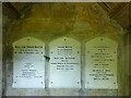
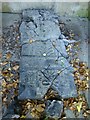
Martin of Auchendennan Vault: interior
See Image for the outside, and for more information.
The tablets have recently been cleaned (the condition of the kirkyard as a whole has been much improved recently), so this was an opportune time to show the interior of the vault.
A structure lying on the floor in front of the tablets is shown in Image
Image: © Lairich Rig
Taken: 7 Jul 2013
0.08 miles
10
Martin of Auchendennan Vault: interior
See Image for the outside of the vault, and for more on the family commemorated here. For the tablets on the rear wall, see Image (which, like the present picture, is a view through the iron gate).
Image: © Lairich Rig
Taken: 7 Jul 2013
0.08 miles