IMAGES TAKEN NEAR TO
Gartocharn, ALEXANDRIA, G83 8RX
Introduction
This page details the photographs taken nearby to G83 8RX by members of the Geograph project.
The Geograph project started in 2005 with the aim of publishing, organising and preserving representative images for every square kilometre of Great Britain, Ireland and the Isle of Man.

There are currently over 7.5m images from over14,400 individuals and you can help contribute to the project by visiting https://www.geograph.org.uk
Image Map
Images are licensed for reuse under creativecommons.org/licenses/by-sa/2.0
Notes
- Clicking on the map will re-center to the selected point.
- The higher the marker number, the further away the image location is from the centre of the postcode.
Image Listing (50 Images Found)
Images are licensed for reuse under creativecommons.org/licenses/by-sa/2.0
Image
Details
Distance
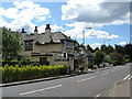
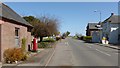
1
Gartocharn from Ross Loan
Another contributor's earlier picture shows much the same view, but in a different season: Image
Image: © Lairich Rig
Taken: 19 Apr 2013
0.02 miles
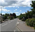
2
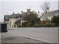
Gartocharn
Photograph taken from bench outside Lomond Stores shop.
Image: © Stephen Sweeney
Taken: 14 Mar 2007
0.03 miles
3
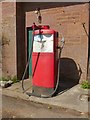
Vintage petrol pump
Image: © Lairich Rig
Taken: 19 Apr 2013
0.04 miles
4
Gartocharn
Image: © Lairich Rig
Taken: 19 Apr 2013
0.04 miles
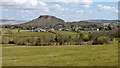
5
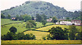
View over Gartocharn to Duncryne Hill (142m)
From the Ross Priory road.
Image: © Stanley Howe
Taken: Unknown
0.04 miles
7
The House of Darrach, Gartocharn
A relatively new gift and coffee shop (established in 2010) on the main road through the village of Gartocharn.
Image: © Richard Sutcliffe
Taken: 5 Sep 2015
0.04 miles

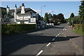
9
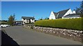
Church Road, Gartocharn
The picture has deliberately been framed with a hedge obscuring most of the building on the right, so as not to be intrusive, but that house was formerly a police station, as is recorded on a panel on the end-wall (the small rectangular panel can be seen in this picture, just above the hedge, at the left-hand end of the building). A 1966 OS map revision — https://maps.nls.uk/view/130200309 — shows a police station here within the corner of Church Road.
Image: © Lairich Rig
Taken: 20 Sep 2019
0.05 miles