IMAGES TAKEN NEAR TO
ALEXANDRIA, G83 8ND
Introduction
This page details the photographs taken nearby to G83 8ND by members of the Geograph project.
The Geograph project started in 2005 with the aim of publishing, organising and preserving representative images for every square kilometre of Great Britain, Ireland and the Isle of Man.

There are currently over 7.5m images from over14,400 individuals and you can help contribute to the project by visiting https://www.geograph.org.uk
Image Map
Images are licensed for reuse under creativecommons.org/licenses/by-sa/2.0
Notes
- Clicking on the map will re-center to the selected point.
- The higher the marker number, the further away the image location is from the centre of the postcode.
Image Listing (15 Images Found)
Images are licensed for reuse under creativecommons.org/licenses/by-sa/2.0
Image
Details
Distance
1

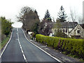
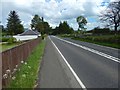
The Gowk Inn on the Old Military Road
The Gowk Inn is on the left. By the end of the nineteenth century, it was offering food and non-alcoholic refreshments, but, earlier in that century, it had been a public house (the first-edition OS map, surveyed in 1860, marks it "P.H."). In that role, it appears to have been popular with the local lairds [see the comments on pages 181-182 of Donald MacLeod's book "Historic Families, Notable People, and Memorabilia of the Lennox" (1891)].
As for the road (the A811), it follows the line of the Old Military Road, as indicated on the 1:25000 map. Most of those who are aware of the network of old military roads in Scotland would probably associate it with the name Wade (General George Wade). However, in 1732, Wade appointed Major William Caulfeild to the position of Inspector of Roads in Scotland; Caulfeild would be responsible for building about three times as many miles of road as Wade.
The Dumbarton to Stirling route, though, is an example of a post-Caulfeild road. It dates from about 1770-80, and local opinion, which is probably correct in this case, is that the work being carried out during this period was realignment of an earlier road to follow the route of the present-day A811 [Reference: William Taylor, "The Military Roads in Scotland" (1996)].
The military road is this area is also mentioned in David Ure's book "General view of the agriculture in the country of Dumbarton ..." (1794). A map at the start of the book shows a road leading from Dumbarton, passing near Balloch and through Kilmaronock. On pages 11-12, Ure says of the roads in that county that "Government, immediately after the rebellion in the year 1745, opened some great roads in this part of the Highlands. They were made by the troops at the public expense; and are known by the name of military roads. They were the first well made highways in the county. One of them goes from Dumbarton through the parishes of Bonhill, and Kilmaronack, the extent of eleven miles ... [discussion of two other roads omitted] ... The first of these roads was, till of late, upheld by Government; but is now given up. An application is about to be laid before Parliament for leave to erect turnpikes upon it, to keep it in repair".
Image: © Lairich Rig
Taken: 22 Mar 2012
0.01 miles
2

Old milestone & old milepost
On the A811 north from Alexandria and Dumbarton and opposite the Gowk Inn, now a house, are these two mile markers. The upper red sandstone set in the wall bordering Auchenlinnhe House is like the stone in Drymen opposite the Buchanan Arms at Image The metal plate is one of the posts erected at the turn of the 19/20C. The Dunbarton 6 and 8 plates were still in place a few years ago.
Image: © Willy Findlay
Taken: 3 Nov 2021
0.02 miles
3

Old milestone
This shows the left-hand side of the red sandstone milestone set in the wall surrounding Auchenlinnhe House. The top of the newer metal milepost can just be seen. 27 is the mileage from Stirling. MS is shown on the 1776 Taylor & Skinner map and this is the route of the Old Military Road built between 1765-97 by Major William Caufeild.
Image: © Willy Findlay
Taken: 3 Nov 2021
0.02 miles
4
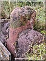
Old milestone
The right-hand face of the red sandstone milestone in the wall surrounding Auchenlinnhe House. The inscribed 7 is the mileage to Dumbarton.
Image: © Willy Findlay
Taken: 3 Nov 2021
0.02 miles
5
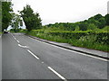
Old Military Road near the Gowk
The view is from further along the road shown in Image, from just past the junctions mentioned there.
Image: © Lairich Rig
Taken: 18 May 2017
0.04 miles
7
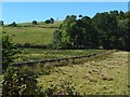
Land between two walls
The 1:25000 map shows two walls leading away from the near edge of the woods on the right: one wall, the nearer as seen from here, heads southeast, while the other heads south. Those two walls and the wedge of grassland they enclose can be seen near the centre of this picture. The view is from the pavement of Image
Image: © Lairich Rig
Taken: 20 Sep 2019
0.08 miles
8
Old Military Road near the Gowk
Image is a little further on. The picture was taken just after passing a house called Nowitna (which is the name of a river in Alaska).
As the 1:25000 map shows, there is, on the near side of the house visible ahead, the start of a Image; note the mirror facing the junction. Beside that mirror, on the right-hand side of the road, is a Image
Just past the junctions, the road feels more enclosed by greenery: Image
Image: © Lairich Rig
Taken: 18 May 2017
0.09 miles
9
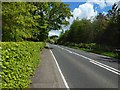
A811 to Balloch just after Gartocharn.
Image: © Johnny Durnan
Taken: 18 Jun 2006
0.09 miles
10
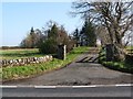
Track to Auchenlinnhe
This entrance faces that of a Image The name Auchenlinnhe seems out of place among those of the neighbouring farms (many of which contain the element "Blair"), but this may be because the buildings date from as recently as the twentieth century (they are located on the same site as an earlier structure, but there was an intervening period when no buildings were there). This may also be why the name looks superficially Gaelic, but its second half is spelled oddly, from a Gaelic perspective.
[The "Blair-" placenames that are common in this area appears to represent subdivisions of an original "Blair" (< Gael. "Blàr" = "muir", "field"); see the chapter by Simon Taylor in "Changing Identities, Ancient Roots" (2007).]
Image: © Lairich Rig
Taken: 22 Mar 2012
0.11 miles