IMAGES TAKEN NEAR TO
Inchlonaig Drive, ALEXANDRIA, G83 8JH
Introduction
This page details the photographs taken nearby to Inchlonaig Drive, G83 8JH by members of the Geograph project.
The Geograph project started in 2005 with the aim of publishing, organising and preserving representative images for every square kilometre of Great Britain, Ireland and the Isle of Man.

There are currently over 7.5m images from over14,400 individuals and you can help contribute to the project by visiting https://www.geograph.org.uk
Image Map
Images are licensed for reuse under creativecommons.org/licenses/by-sa/2.0
Notes
- Clicking on the map will re-center to the selected point.
- The higher the marker number, the further away the image location is from the centre of the postcode.
Image Listing (18 Images Found)
Images are licensed for reuse under creativecommons.org/licenses/by-sa/2.0
Image
Details
Distance
1
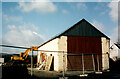
The end of Mollanbowie Farm
The area occupied by the current Mollanbowie housing estate (built by John Lawrence) had always been farmland until the late 1950’s.
John McNeil’s farm once stood at the bend half way up Mollanbowie Road in the space now occupied by 25 Mollanbowie Rd.
The last traces of the farm were removed in 2002 with the Byre being the last to be demolished.
Image: © Pete Marrison
Taken: Unknown
0.07 miles
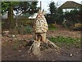
2
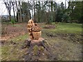
Chainsaw art in Balloch Park
A small "fairy house" (compare Image, taken in a different park a few miles from here) can be seen in the background: Image Another, not visible in this picture, is a little farther away, close to the park boundary.
Image: © Lairich Rig
Taken: 18 Jan 2017
0.13 miles
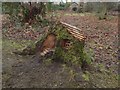
5

Beside the walled garden at Balloch Park
Like Image, this picture includes the south-eastern corner of the walled garden, but the view is in the opposite direction. The pictures were taken on the same evening.
Image: © Lairich Rig
Taken: 21 Jul 2016
0.22 miles
6
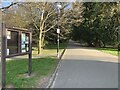
Path,
Start of the Balloch Castle country park walk. Path within the park looking north.
Image: © George Rankin
Taken: 6 Apr 2021
0.22 miles
7
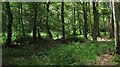
Moss o' Balloch Plantations
Mature woodland in Balloch Castle Country Park.
Image: © Richard Webb
Taken: 15 Jun 2010
0.23 miles
8

Beside the walled garden at Balloch Park
The path rounds the south-east corner of the walled garden here.
The tallest tree in the background is a Wellingtonia (Sequoiadendron giganteum). Its bark is soft and fibrous, and people passing this tree, and others like it, do on occasion put this to the test by punching the bark; the near side of the tree showed clear signs of this.
See Image for a view in the opposite direction, past the same corner of the walled garden.
Image: © Lairich Rig
Taken: 21 Jul 2016
0.23 miles
9
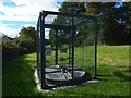
Gas infrastructure
This structure is on a high pressure crude pipeline. The view is from Mollanbowie Road in Balloch.
Image: © Lairich Rig
Taken: 21 Sep 2018
0.23 miles
10
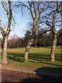
Trees in the Moss o'Balloch Plantation
At the southern end of Balloch Castle Country Park
Image: © Graham Hogg
Taken: 17 Nov 2018
0.23 miles