IMAGES TAKEN NEAR TO
Ledrish Avenue, ALEXANDRIA, G83 8JB
Introduction
This page details the photographs taken nearby to Ledrish Avenue, G83 8JB by members of the Geograph project.
The Geograph project started in 2005 with the aim of publishing, organising and preserving representative images for every square kilometre of Great Britain, Ireland and the Isle of Man.

There are currently over 7.5m images from over14,400 individuals and you can help contribute to the project by visiting https://www.geograph.org.uk
Image Map
Images are licensed for reuse under creativecommons.org/licenses/by-sa/2.0
Notes
- Clicking on the map will re-center to the selected point.
- The higher the marker number, the further away the image location is from the centre of the postcode.
Image Listing (12 Images Found)
Images are licensed for reuse under creativecommons.org/licenses/by-sa/2.0
Image
Details
Distance
1
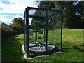
Gas infrastructure
This structure is on a high pressure crude pipeline. The view is from Mollanbowie Road in Balloch.
Image: © Lairich Rig
Taken: 21 Sep 2018
0.09 miles
2
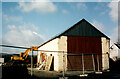
The end of Mollanbowie Farm
The area occupied by the current Mollanbowie housing estate (built by John Lawrence) had always been farmland until the late 1950’s.
John McNeil’s farm once stood at the bend half way up Mollanbowie Road in the space now occupied by 25 Mollanbowie Rd.
The last traces of the farm were removed in 2002 with the Byre being the last to be demolished.
Image: © Pete Marrison
Taken: Unknown
0.11 miles
3
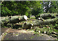
Mollanbowie Road Storm
On Monday 23 May 2011, shortly after midday, winds of up to 100 mph swept across parts of Scotland. At one stage 50,000 homes were without electricity; felled power lines and trees blocked train tracks and major roads. Ferry operator CalMac cancelled more than half of its services.
Sadly there was also one fatality. At the top of Mollanbowie Road a massive oak tree uprooted and hit a passing van driven by a young family man.
https://www.bbc.co.uk/news/uk-scotland-glasgow-west-13512698
https://www.dailyrecord.co.uk/news/local-news/inquiry-death-freak-storm-driver-2410916
Image: © Pete Marrison
Taken: 23 May 2011
0.12 miles
4

10-Spot Ladybird
(Adalia 10-punctata)
This particular example was not far from the road (Image), near an area of woodland.
At first, I took this to be a Cream-streaked Ladybird (Harmonia quadripunctata = Harmonia 4-punctata). However, on revisiting it, I came to the conclusion that it is instead a 10-spot Ladybird (Adalia decempunctata = Adalia 10-punctata). That species is very variable in appearance, but the pronotum (plate above the head), at least, seems distinctive enough.
See http://www.coleoptera.org.uk/species/adalia-decempunctata (at UK Beetle Recording) for pictures and for further information.
Image: © Lairich Rig
Taken: 23 May 2014
0.15 miles
5
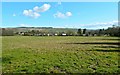
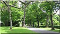
Field at Balloch
The picture was taken from the road between Image and the north lodge (Image): Image Of the houses in the background, the nearest ones are on Inchfad Road and on the small inshots just to the north of that road.
Image: © Lairich Rig
Taken: 14 Apr 2014
0.17 miles
6
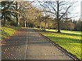
Balloch Castle Country Park
This photograph was taken from the same spot as Image, but is a view in the opposite direction. Not far ahead, the path enters an area of woodland which extends to the southern entrance of the park.
Image: © Lairich Rig
Taken: 4 Nov 2011
0.18 miles
7
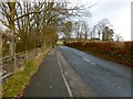
Mollanbowie Road, Balloch
The road ends in a T-junction; from there, the left branch leads to the Image
Image: © Lairich Rig
Taken: 23 Nov 2012
0.19 miles
8
Road, Balloch Castle Country Park
Drive to Balloch Castle - looking towards the North Lodge. This is one of the public routes into the country park.
Image: © Richard Webb
Taken: 15 Jun 2010
0.23 miles
9
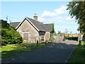
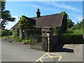
North Lodge, Balloch Castle Country Park
This was the north lodge of Image For the road leading to the lodge, see Image and Image
There is also a south lodge, which is beside the main pedestrian entrance to the park: Image
Image: © Lairich Rig
Taken: 29 Jul 2011
0.24 miles
10
North Lodge, Balloch Castle Country Park
For a view from another angle, see Image In the present picture, it is just possible to pick out a bench mark near the bottom of the near side of the gate post. It is one of two that I happened to notice on the day (for the other, see Image).
I photographed the bench mark itself later on, when it was not half in sunlight and half in shadow: Image
Image: © Lairich Rig
Taken: 6 Jun 2018
0.24 miles