IMAGES TAKEN NEAR TO
Miller Road, ALEXANDRIA, G83 8FG
Introduction
This page details the photographs taken nearby to Miller Road, G83 8FG by members of the Geograph project.
The Geograph project started in 2005 with the aim of publishing, organising and preserving representative images for every square kilometre of Great Britain, Ireland and the Isle of Man.

There are currently over 7.5m images from over14,400 individuals and you can help contribute to the project by visiting https://www.geograph.org.uk
Image Map
Images are licensed for reuse under creativecommons.org/licenses/by-sa/2.0
Notes
- Clicking on the map will re-center to the selected point.
- The higher the marker number, the further away the image location is from the centre of the postcode.
Image Listing (54 Images Found)
Images are licensed for reuse under creativecommons.org/licenses/by-sa/2.0
Image
Details
Distance
1
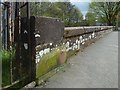
Bench mark on Miller Road
This 3rd-order cut benchmark is on a stone at the northern end of the east parapet of the bridge where Miller Road crosses the Carrochan Burn. It is 17.458m above Newlyn datum (according to the OS database).
The upper surface of the stone above it has some interesting details, not visible from this angle: there are rectangular sockets at the corners (as if the stone had formerly supported something else), and some inscribed text:
■ ■
P
N°2
■ ■
Image: © Lairich Rig
Taken: 6 May 2018
0.06 miles
2
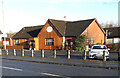
The Stables Restaurant & Bar
This family-run restaurant is situated on the northeast side of Carrochan Road, Balloch (A813), half way between Balloch and Jamestown. It was originally known as the "Roundabout Inn". It closed indefinitely in autumn 2022.
Image: © Pete Marrison
Taken: 22 Nov 2022
0.10 miles
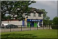
3
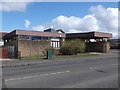
Balloch Library
On Carrochan Road (the A813) from Balloch into Jamestown. See http://www.find-a-library.co.uk/uk/balloch-library/3510 .
Image: © Barbara Carr
Taken: 21 Apr 2013
0.11 miles
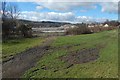
4
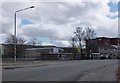
Entering Jamestown on the A813
The building in centre of picture is Lennox Hall, Jamestown's parish church hall.
Image: © Barbara Carr
Taken: 21 Apr 2013
0.12 miles
5
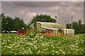
Haldane Leisure Barn
Due to the lack of facilities for both the young and the elderly, the Leisure Barn was built in Haldane in 1994.
It was hoped that it could be used and run by the community.
The immediate area around the barn is very run down. It is not user friendly for either the disabled or the elderly and is too isolated from the rest of the community.
There are the remains of an existing concrete base for skateboarding, but it has never been maintained by the Council and is no longer in use.
There is an AstroTurf for 5-a-side football but there are signs up saying that it is dangerous.
Image: © George Rankin
Taken: 9 Jun 2007
0.12 miles
6
Site of Balloch Shared Campus
The view is from Main Street, opposite the junction with Miller Road.
Image: © Lairich Rig
Taken: 5 Apr 2016
0.13 miles
7
Village Store
A view of the village store in Jamestown, although this shop is called Morning Noon and Night (Co-op) it is known by the locals as Strangs as it is on the site of a smaller store of that name.
Image: © George Rankin
Taken: 9 Jun 2007
0.13 miles
8
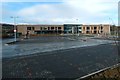
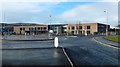
Balloch Shared Campus
The building was complete, but not yet in use; it would open just a few days later. See also Image, taken on the same day as the present picture.
Click on the end-note title for related pictures.
Image: © Lairich Rig
Taken: 11 Feb 2018
0.14 miles
9
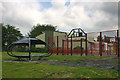
5-a-side Courts
Playing fields and 5-a-side courts in the Inler Park, Haldne.
Image: © George Rankin
Taken: 9 Jun 2007
0.14 miles
10
Balloch Shared Campus
This seemed a good time to complete my sequence of construction pictures: the school was not yet in use (it was still fenced off), but it did appear to be complete. That was the case; it opened just a few days later.
See also Image, taken on the same day as the present picture.
Click on the end-note title for related photographs.
Image: © Lairich Rig
Taken: 11 Feb 2018
0.14 miles