IMAGES TAKEN NEAR TO
Levenbank Street, ALEXANDRIA, G83 8EQ
Introduction
This page details the photographs taken nearby to Levenbank Street, G83 8EQ by members of the Geograph project.
The Geograph project started in 2005 with the aim of publishing, organising and preserving representative images for every square kilometre of Great Britain, Ireland and the Isle of Man.

There are currently over 7.5m images from over14,400 individuals and you can help contribute to the project by visiting https://www.geograph.org.uk
Image Map
Images are licensed for reuse under creativecommons.org/licenses/by-sa/2.0
Notes
- Clicking on the map will re-center to the selected point.
- The higher the marker number, the further away the image location is from the centre of the postcode.
Image Listing (74 Images Found)
Images are licensed for reuse under creativecommons.org/licenses/by-sa/2.0
Image
Details
Distance
1
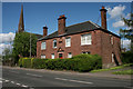
House on Main Street, Jamestown
A large red sandstone house, with an inscription above the door '1899'. Behind is Jamestown Parish Church.
Image: © Richard Sutcliffe
Taken: 11 May 2019
0.02 miles
2
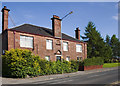
Arthurston House Jamestown
Arthurston House in Jamestown was built in 1899 the town had a history of cloth printing. Buildings on the banks of the river Leven from Dalvait to Bonhill Bridge were all printworks. The printworks lay derelict for many years until eventually they were demolished. Ninety percent of Jamestown’s houses were demolished in the late 60’s making this one of the oldest in the area. Jamestown also had a railway station and it was next to Arthurston House, it was the first stop on the Balloch to Stirling line.
Image: © George Rankin
Taken: 21 May 2007
0.02 miles
3
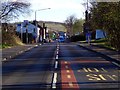
Main Street, Jamestown, Alexandria
View of Main Street, Jamestown from south position on road facing north.
Image: © George Rankin
Taken: 27 Apr 2016
0.02 miles
4
The A813 through Jamestown
To the right, Jamestown Industrial Estate, behind the entrance of which can be seen the spire of Jamestown Parish Church Image To the left, the Rowantree Tavern: see http://www.rowantreetavern.co.uk/ .
Image: © Barbara Carr
Taken: 21 Apr 2013
0.02 miles
5
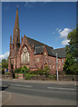
Jamestown Parish Church
Category B listed church [http://portal.historicenvironment.scot/designation/LB1137], dating from 1869-70.
Image: © Richard Sutcliffe
Taken: 11 May 2019
0.03 miles
6
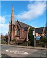
Jamestown Parish Church
For information about the building, see Image On the occasion of the present photograph, repairs had recently been taking place on the steeple; compare Image (with scaffolding).
Other earlier pictures: Image / Image
Image: © Lairich Rig
Taken: 19 Oct 2011
0.03 miles
7
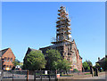
Jamestown Parish Church
The steeple of this Church of Scotland building is covered in scaffolding.
Image: © David P Howard
Taken: 23 Jul 2011
0.03 miles
8
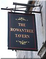
Sign for the Rowantree Tavern
Former public house in Jamestown [https://www.geograph.org.uk/photo/6149384].
Image: © Richard Sutcliffe
Taken: 11 May 2019
0.03 miles
9
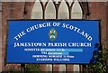
Sign, Jamestown Parish Church
Although the sign looks bright and fresh, the church itself appears to have boarded up windows, suggesting it is not currently in use.
Image: © Richard Sutcliffe
Taken: 11 May 2019
0.03 miles
10
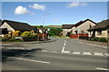
Heatherdale
Looking towards Honeysuckle Lane in Heatherdale, Jamestown, from Main Street, Jamestown, A813.
Image: © George Rankin
Taken: 14 May 2007
0.03 miles