IMAGES TAKEN NEAR TO
Mollanbowie Road, ALEXANDRIA, G83 8EJ
Introduction
This page details the photographs taken nearby to Mollanbowie Road, G83 8EJ by members of the Geograph project.
The Geograph project started in 2005 with the aim of publishing, organising and preserving representative images for every square kilometre of Great Britain, Ireland and the Isle of Man.

There are currently over 7.5m images from over14,400 individuals and you can help contribute to the project by visiting https://www.geograph.org.uk
Image Map
Images are licensed for reuse under creativecommons.org/licenses/by-sa/2.0
Notes
- Clicking on the map will re-center to the selected point.
- The higher the marker number, the further away the image location is from the centre of the postcode.
Image Listing (20 Images Found)
Images are licensed for reuse under creativecommons.org/licenses/by-sa/2.0
Image
Details
Distance
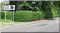
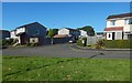
1
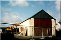
The end of Mollanbowie Farm
The area occupied by the current Mollanbowie housing estate (built by John Lawrence) had always been farmland until the late 1950’s.
John McNeil’s farm once stood at the bend half way up Mollanbowie Road in the space now occupied by 25 Mollanbowie Rd.
The last traces of the farm were removed in 2002 with the Byre being the last to be demolished.
Image: © Pete Marrison
Taken: Unknown
0.09 miles
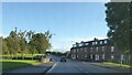
2
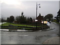
Entrance to Balloch
From the A811 road from the direction of Stirling.
Image: © Stephen Sweeney
Taken: 31 Jan 2007
0.14 miles
3
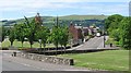
Welcome to Balloch
Approaching Balloch from the east. View down Drymen Road.
Image: © Richard Webb
Taken: 15 Jun 2010
0.15 miles
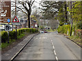
4
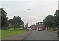
A811 junction with Drymen road
A811 becomes Stirling Road beyond this point
Image: © John Firth
Taken: 26 Jul 2012
0.17 miles
5
Sign, A811
More roadside clutter on the edge of Balloch. There were no fixed cameras on the road at the time of submission, but the vans are a common sight along the road to Stirling.
Usually on this road you will be stuck behind either: a lorry, tractor, scenery braked Micra or a large slow moving cyclist taking photographs for Geograph, so the temptation to speed will not be present.
Image: © Richard Webb
Taken: 15 Jun 2010
0.18 miles
7
Balloch, Stirling Road
Entering Balloch via the A811, Stirling Road.
Image: © David Dixon
Taken: 19 Apr 2012
0.19 miles
8
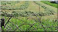
Mown grass
Silage crop awaiting baling and bagging.
Image: © Richard Webb
Taken: 15 Jun 2010
0.20 miles
9
McLean Crescent
It is shown branching off from McKenzie Drive, which is in the foreground. The view is from Lomond Road.
Image: © Lairich Rig
Taken: 20 Sep 2019
0.20 miles
10
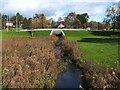
The Ballagan Burn
This is the view upstream from a Image The small bridge ahead carries a road over the burn; it is shown from the other side in Image
Image: © Lairich Rig
Taken: 19 Oct 2011
0.22 miles