IMAGES TAKEN NEAR TO
Carmona Drive, ALEXANDRIA, G83 8AL
Introduction
This page details the photographs taken nearby to Carmona Drive, G83 8AL by members of the Geograph project.
The Geograph project started in 2005 with the aim of publishing, organising and preserving representative images for every square kilometre of Great Britain, Ireland and the Isle of Man.

There are currently over 7.5m images from over14,400 individuals and you can help contribute to the project by visiting https://www.geograph.org.uk
Image Map
Images are licensed for reuse under creativecommons.org/licenses/by-sa/2.0
Notes
- Clicking on the map will re-center to the selected point.
- The higher the marker number, the further away the image location is from the centre of the postcode.
Image Listing (44 Images Found)
Images are licensed for reuse under creativecommons.org/licenses/by-sa/2.0
Image
Details
Distance
1
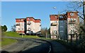
Woodburn Avenue
See Image for a view in the opposite direction from about the same place. The area of housing as a whole is called the Haldane.
Image: © Lairich Rig
Taken: 25 Feb 2013
0.04 miles
2
Woodburn Avenue
Image is on the right. In the area in the right foreground, with trees in it, the Carrochan Burn – http://www.geograph.org.uk/tagged/the+Carrochan+Burn – enters the park.
See Image for a view in the opposite direction from about the same place. The area of housing as a whole is called the Haldane.
The spire near the far end of the road is that of Image
Image: © Lairich Rig
Taken: 25 Feb 2013
0.07 miles
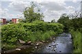
3
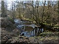
The Carrochan Burn
This is a view downstream from the point shown in Image, where the footpath to Auchincarroch Road crosses over the burn.
Image: © Lairich Rig
Taken: 25 Feb 2013
0.09 miles
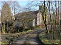
4
Carmona Drive
This is one endpoint of the route that is described in the end-note; the footpath enters the Haldane at this point on Carmona Drive.
For the other endpoint of the route, see Image
Image: © Lairich Rig
Taken: 25 Feb 2013
0.10 miles
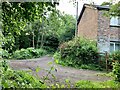
5
Footpath crossing the Carrochan Burn
In this picture, which was taken near Carmona Drive, the footpath crosses the Carrochan Burn in front of the right-hand side of the building. For the view downstream from there, see Image
Image: © Lairich Rig
Taken: 25 Feb 2013
0.10 miles
6
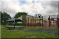
5-a-side Courts
Playing fields and 5-a-side courts in the Inler Park, Haldne.
Image: © George Rankin
Taken: 9 Jun 2007
0.10 miles
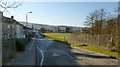
7
Red Craig and path
Arthurston road leading to Carmona Drive, with Red Craig house on the right hand side. The Carrochan burn runs along side Red Craig but can’t be seen in this photograph.
Image: © George Rankin
Taken: 25 Jun 2021
0.11 miles
8
Haldane Burn
View of the burn that runs through Haldane park, with the "electric flats" in Davidson Road on the left in the background
Image: © George Rankin
Taken: 9 Jun 2007
0.12 miles
9
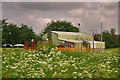
Haldane Leisure Barn
Due to the lack of facilities for both the young and the elderly, the Leisure Barn was built in Haldane in 1994.
It was hoped that it could be used and run by the community.
The immediate area around the barn is very run down. It is not user friendly for either the disabled or the elderly and is too isolated from the rest of the community.
There are the remains of an existing concrete base for skateboarding, but it has never been maintained by the Council and is no longer in use.
There is an AstroTurf for 5-a-side football but there are signs up saying that it is dangerous.
Image: © George Rankin
Taken: 9 Jun 2007
0.12 miles
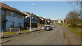
10
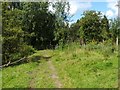
Footpath to Carmona Drive
This is a view from a little further along the path shown in Image
After entering the woods, the footpath crosses the Carrochan Burn before reaching Carmona Drive.
Image: © Lairich Rig
Taken: 13 Aug 2010
0.13 miles