IMAGES TAKEN NEAR TO
Ardlui, ARROCHAR, G83 7ED
Introduction
This page details the photographs taken nearby to G83 7ED by members of the Geograph project.
The Geograph project started in 2005 with the aim of publishing, organising and preserving representative images for every square kilometre of Great Britain, Ireland and the Isle of Man.

There are currently over 7.5m images from over14,400 individuals and you can help contribute to the project by visiting https://www.geograph.org.uk
Image Map
Images are licensed for reuse under creativecommons.org/licenses/by-sa/2.0
Notes
- Clicking on the map will re-center to the selected point.
- The higher the marker number, the further away the image location is from the centre of the postcode.
Image Listing (7 Images Found)
Images are licensed for reuse under creativecommons.org/licenses/by-sa/2.0
Image
Details
Distance
1
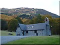
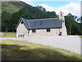
Church near Ardlui
Recently refurbished as a dwelling.
Image: © Alan Reid
Taken: 25 Oct 2012
0.01 miles
3
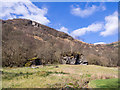
Boulders at foot of mountain slope
The boulders lie on a slope just above the A82 north of Ardlui. The slopes rise to Stob an Fhithich, at the northern end of Ben Vorlich.
Image: © Trevor Littlewood
Taken: 11 Apr 2016
0.03 miles