IMAGES TAKEN NEAR TO
ARROCHAR, G83 7AS
Introduction
This page details the photographs taken nearby to G83 7AS by members of the Geograph project.
The Geograph project started in 2005 with the aim of publishing, organising and preserving representative images for every square kilometre of Great Britain, Ireland and the Isle of Man.

There are currently over 7.5m images from over14,400 individuals and you can help contribute to the project by visiting https://www.geograph.org.uk
Image Map
Images are licensed for reuse under creativecommons.org/licenses/by-sa/2.0
Notes
- Clicking on the map will re-center to the selected point.
- The higher the marker number, the further away the image location is from the centre of the postcode.
Image Listing (11 Images Found)
Images are licensed for reuse under creativecommons.org/licenses/by-sa/2.0
Image
Details
Distance
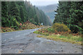
4
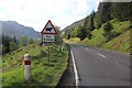
The climb to the Rest and be Thankful begins
This gradient on the A83 is maintained without variation to the summit. The penalty for this engineering feat has been a weakening of sections of the upper slope and has led to numerous landslips closing the road. The old single track road generally followed the contours of the ground with minimal disturbance to them and did not suffer the same problem.
Image: © Alan Reid
Taken: 27 May 2013
0.05 miles
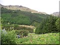
5
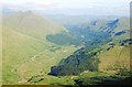
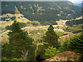
Glen Croe from the summit of Beinn an Lochain
The whole of the upper glen can be seen in this view, from the Rest and Be Thankful down as far as the bend above the Little Rest.
The main A83 road to Argyll climbs steadily along the slopes above the old Military Road which follows the bottom of the glen. The new road is plagued with landslips and the old road has recently been overhauled to provide an emergency alternative route.
The glen is guarded to the left by The Cobbler (Ben Arthur) and to the right by The Brack. Ben Lomond can be seen in the left distance. The ridge in the right middle distance is on Ben Donich and the road in front of that is the B828 to Lochgoilhead.
Image: © Patrick Mackie
Taken: 10 Jul 2013
0.06 miles
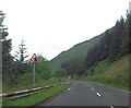
6
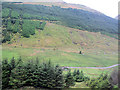
Laigh Glencroe from A83
The livestock pens can just be seen next to trees below centre. The old road winds past them
Image: © John Firth
Taken: 10 May 2011
0.14 miles
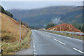
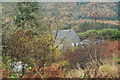
8
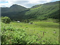
Glen Croe
The base of Glen Croe viewed from a track high on the south side of the glen
Image: © Iain Thompson
Taken: 13 Apr 2009
0.19 miles
9
Looking towards the river in Glen Croe
The river is Croe Water.
Image: © David Medcalf
Taken: 29 Jun 2014
0.20 miles