IMAGES TAKEN NEAR TO
St. Andrews Lane, ALEXANDRIA, G83 0SX
Introduction
This page details the photographs taken nearby to St. Andrews Lane, G83 0SX by members of the Geograph project.
The Geograph project started in 2005 with the aim of publishing, organising and preserving representative images for every square kilometre of Great Britain, Ireland and the Isle of Man.

There are currently over 7.5m images from over14,400 individuals and you can help contribute to the project by visiting https://www.geograph.org.uk
Image Map
Images are licensed for reuse under creativecommons.org/licenses/by-sa/2.0
Notes
- Clicking on the map will re-center to the selected point.
- The higher the marker number, the further away the image location is from the centre of the postcode.
Image Listing (154 Images Found)
Images are licensed for reuse under creativecommons.org/licenses/by-sa/2.0
Image
Details
Distance
1
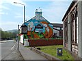
Laughing Fox mural
This mural, on the side of the Laughing Fox lounge bar on Bridge Street in Alexandria, is new; the artist, Barry the Cat, had completed it about a week before the picture was taken. Note the chimney detail.
In the right foreground is part of the Image
See also Image, a nearby mural painted by same artist a little later.
Image: © Lairich Rig
Taken: 8 May 2016
0.04 miles
2
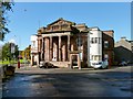
Former public hall, Alexandria
Amongst other things, this has been public hall, a cinema, and a bingo club. The date 1862 appears in the roundel at the top of the building. For further details, see Image
Image: © Lairich Rig
Taken: 5 Oct 2012
0.05 miles
3
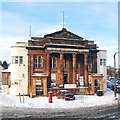
Former public hall, Alexandria
This category B listed building stands at the junction of Bridge Street and Bank Street (visible on the right), and was built in 1862 as a public hall. It was later put to use as the Hall Cinema, and then, as the remaining lettering shows, the Vale Bingo Club. At the time when this photograph was taken, it was being used as a furniture showroom. For another view, see Image
Its listed building report provides further details: http://portal.historic-scotland.gov.uk/designation/LB43193 (at Historic Environment Scotland).
An old photograph of Bonhill Bridge from c.1893 shows a small structure in front of this building: a drinking fountain, which was "a gift to the community by the Smolletts, and was erected in 1879 to commemorate the opening of the 'Tank' or Overton Reservoir (Image). The fountain was removed in the 1930s presumably because cars were more reluctant to go round it than horses had been" ["The Old Vale and the New", Jones/Hopner, 1981].
(The reservoir mentioned above is shown in Image)
Image: © Lairich Rig
Taken: 29 Nov 2010
0.05 miles
4
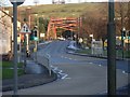
Looking to the Bonhill Bridge
From along Bridge Street, beside the station.
Image: © Stephen Sweeney
Taken: 6 Dec 2008
0.05 miles
5

High flats at Riverside
These flats are located in the appropriately-named Riverside area; the nearer two stand on Thomas Street, and the other on Angus Street. The lower buildings at the left-hand edge of the picture are part of St Ronan's Lane.
National Cycle Network route 7 is visible in the foreground.
For a similar view about a year later, see Image
Image: © Lairich Rig
Taken: 21 Sep 2008
0.05 miles
6
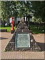
Pyramid with Bonhill Bridge plaque
There are three of these small pyramids standing here in a car-parking area at the riverside, next to Bonhill Bridge; of these, only the one shown in this image bears a plaque (by 2015, the plaque had gone). Its text reads:
"Bonhill Bridge
erected by
the County Council of Dunbarton
was opened for traffic
on 2nd July 1898.
Convener of the County
The Rt. Honble. Lord Overtoun.
Chairman of the Road Board
John Gilmour Esqr."
Note that the plaque does not describe the existing (as of 2009) bridge (see Image), but, rather, its immediate predecessor.
The white building visible through the trees, in the background, was (when this picture was taken) used by a dental practice.
Image: © Lairich Rig
Taken: 21 Sep 2008
0.06 miles
7

Bonhill Bridge
The New Bridge built 1986 which replaced the Black Bridge built in 1898, replacing a suspension bridge of 1836 built by Admiral Smollett.
Image: © william craig
Taken: 23 Mar 2006
0.07 miles
8
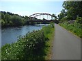
Riverside path near the Bonhill Bridge
There is a patch of Image in the foreground.
Image: © Lairich Rig
Taken: 24 May 2018
0.07 miles
9
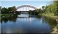
Bonhill Bridge
The current bridge dates from 1986, and replaced an earlier bridge (built in 1898). It carries Bridge Street over the River Leven.
Image: © Richard Sutcliffe
Taken: 11 May 2019
0.07 miles
10
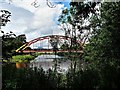
Bonhill Bridge ("Rainbow Bridge") - River Leven
The original Bonhill Bridge (Bawbee Bridge) was built in 1836. It was a chain suspension bridge and was nicknamed "Bawbee Bridge" due to the charge made for a person to cross it.
The second Bonhill Bridge was opened in 1898 and was nicknamed "Whipple Arch". It had a span of 50m and a width of 11.5m. The steel bridge was supported on four red sandstone abutments and carried the usual utilities as well as the tramlines for this new form of transport in the area.
The third Bonhill Bridge was nicknamed “Rainbow Bridge” and the first car drove over it on 28 July 1987. It is made of 284 tonnes of steel, with a span of 60m and width of 14.5m.
Image: © Raibeart MacAoidh
Taken: 19 Jun 2019
0.07 miles