IMAGES TAKEN NEAR TO
Thomas Street, ALEXANDRIA, G83 0ST
Introduction
This page details the photographs taken nearby to Thomas Street, G83 0ST by members of the Geograph project.
The Geograph project started in 2005 with the aim of publishing, organising and preserving representative images for every square kilometre of Great Britain, Ireland and the Isle of Man.

There are currently over 7.5m images from over14,400 individuals and you can help contribute to the project by visiting https://www.geograph.org.uk
Image Map
Images are licensed for reuse under creativecommons.org/licenses/by-sa/2.0
Notes
- Clicking on the map will re-center to the selected point.
- The higher the marker number, the further away the image location is from the centre of the postcode.
Image Listing (156 Images Found)
Images are licensed for reuse under creativecommons.org/licenses/by-sa/2.0
Image
Details
Distance
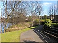
1
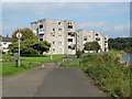
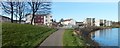
High flats at Riverside
These flats are located in the appropriately-named Riverside area; the nearer two stand on Thomas Street, and the other on Angus Street. The lower buildings at the left-hand edge of the picture are part of St Ronan's Lane.
National Cycle Network route 7 is visible in the foreground.
For a similar view about a year later, see Image
Image: © Lairich Rig
Taken: 21 Sep 2008
0.04 miles
2
Vale of Leven Baptist Church
The building appears on the first-edition map (surveyed in 1860), on which it is annotated "U.P.Church" (United Presbyterian). See Image for a slightly closer look.
Image: © Lairich Rig
Taken: 25 Dec 2014
0.05 miles
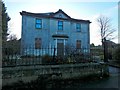
3
Vale of Leven Baptist Church
The building is on Bridge Street, Alexandria. The present picture is a slightly closer view (though still from outside the gate) of the building shown in Image
Image: © Lairich Rig
Taken: 25 Dec 2014
0.05 miles
4
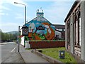
Laughing Fox mural
This mural, on the side of the Laughing Fox lounge bar on Bridge Street in Alexandria, is new; the artist, Barry the Cat, had completed it about a week before the picture was taken. Note the chimney detail.
In the right foreground is part of the Image
See also Image, a nearby mural painted by same artist a little later.
Image: © Lairich Rig
Taken: 8 May 2016
0.06 miles
5
Path crossing the Bonhill Burn
Just after passing by Image, the path crosses above the Bonhill Burn at the point where the burn flows into the River Leven, as shown in this picture. From here, it is only about 200 metres to Image
The name Pappert Burn is also used, perhaps referring more particularly to its upper reaches.
Image: © Lairich Rig
Taken: 25 Feb 2013
0.08 miles
6
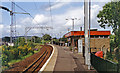
Alexandria station
View north, towards Balloch Pier: ex-NB & Caledonian (Dumbarton & Balloch) Joint branch from Dumbarton Central to Balloch Pier, electrified in November 1960.
Image: © Ben Brooksbank
Taken: 22 Jun 1994
0.08 miles
7
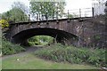
Original railway bridge at Bridge Street Alexandria
This shot; looking east, shows the original railway bridge at Bridge Street Alexandria and is just south of Alexandria station.
Image: © Eddie Mackinnon
Taken: 26 May 2010
0.08 miles
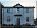
8
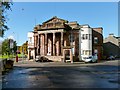
Former public hall, Alexandria
Amongst other things, this has been public hall, a cinema, and a bingo club. The date 1862 appears in the roundel at the top of the building. For further details, see Image
Image: © Lairich Rig
Taken: 5 Oct 2012
0.08 miles
9
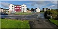
Construction at Riverside
The area is called Riverside. The large building left of centre is being built on what was previously a grassy area in front of Image (visible at the far left in the present photograph). The Image are on the right.
As for the buildings that were under construction when this picture was taken, they are in Leven Street. According to a plaque on a stone at the north-western end of the development, this area of new housing was officially opened by Keith Brown MSP, Minister for Housing and Transport, on the 6th of June, 2012.
See also Image, taken when construction was complete.
Image: © Lairich Rig
Taken: 30 Mar 2012
0.09 miles
10
Leven Street housing
The large building shown left of centre is one of several that had recently been built on Leven Street (the others are behind it). They were completed just a few months before this picture was taken, and they were officially opened in June of 2012. Compare Image, which was taken while construction was in progress.
The section of track in the right foreground is a footpath and cycle route that follows the western bank of the River Leven; it continues along the road on the right.
Image: © Lairich Rig
Taken: 5 Oct 2012
0.09 miles