IMAGES TAKEN NEAR TO
Rowantree Grove, ALEXANDRIA, G83 0SH
Introduction
This page details the photographs taken nearby to Rowantree Grove, G83 0SH by members of the Geograph project.
The Geograph project started in 2005 with the aim of publishing, organising and preserving representative images for every square kilometre of Great Britain, Ireland and the Isle of Man.

There are currently over 7.5m images from over14,400 individuals and you can help contribute to the project by visiting https://www.geograph.org.uk
Image Map
Images are licensed for reuse under creativecommons.org/licenses/by-sa/2.0
Notes
- Clicking on the map will re-center to the selected point.
- The higher the marker number, the further away the image location is from the centre of the postcode.
Image Listing (121 Images Found)
Images are licensed for reuse under creativecommons.org/licenses/by-sa/2.0
Image
Details
Distance
1
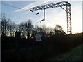
Railway lines by the B857
In Alexandria.
Image: © Stephen Sweeney
Taken: 6 Dec 2008
0.06 miles
2
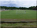
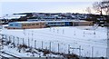
Vale of Leven Football & Athletic Club
View of Vale of Leven Football & Athletic Club's Ground. Vale of Leven Juniors have a long history having been founded in 1939. The club won the Scottish Junior Cup in 1953 and won the "Evening Times" League Championships in 1947 and 1970. The current squad play in the Stagecoach Central District Second Division. The old senior Vale of Leven team won the Scottish Cup three times.
Image: © George Rankin
Taken: 21 Jul 2007
0.07 miles
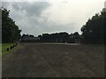
3
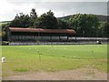
Millburn Park
Home of Vale of Leven Football Club. The current junior club was founded in 1939 after the famous senior club finally folded. In the 19th century, Vale of Leven and Queen's Park dominated Scottish football.
The season had yet to begin as the posts are not yet up. Senior clubs and some of the junior leagues had already started their season by the beginning of September.
Image: © Richard Webb
Taken: 1 Sep 2009
0.08 miles
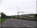
5
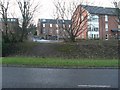
Housing in Alexandria
Looking along Arthur Street from the B857.
Image: © Stephen Sweeney
Taken: 6 Dec 2008
0.09 miles
6
Vale of Leven Academy
Construction of the new Vale of Leven Academy began in 2008, close to the site of the previous building; see Image, which has a link to a view of the old Academy building.
The new school was officially opened on Monday, 9th November, 2009.
For a view from the other side, see Image
Image: © Lairich Rig
Taken: 1 Jan 2010
0.09 miles
7
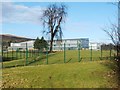
Vale of Leven Academy
The photo was taken from the cycle route; for the main item about the new school building, see Image
Image: © Lairich Rig
Taken: 12 Feb 2010
0.09 miles
8
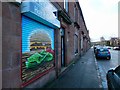
Main Street, Alexandria
I had hoped to get a better view of the artwork in the left foreground, but the grey car parked in front made that impossible. The red sandstone buildings themselves were originally called Mulberry Bank, and they date from 1887.
The location is at the corner of Main Street and Arthur Street. The red sandstone buildings continue to the north, becoming progressively older: those on the other side (north) of Arthur Street date from 1885; Dalmary Place dates from 1884; north of Albert Street is Plane Tree Bank (undated).
Image: © Lairich Rig
Taken: 26 Dec 2017
0.10 miles
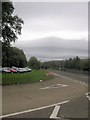
10
Carpark for Millburn Park, Vale of Leven FC
Image: © Steven Brown
Taken: 7 Sep 2023
0.11 miles