IMAGES TAKEN NEAR TO
Susannah Street, ALEXANDRIA, G83 0PW
Introduction
This page details the photographs taken nearby to Susannah Street, G83 0PW by members of the Geograph project.
The Geograph project started in 2005 with the aim of publishing, organising and preserving representative images for every square kilometre of Great Britain, Ireland and the Isle of Man.

There are currently over 7.5m images from over14,400 individuals and you can help contribute to the project by visiting https://www.geograph.org.uk
Image Map
Images are licensed for reuse under creativecommons.org/licenses/by-sa/2.0
Notes
- Clicking on the map will re-center to the selected point.
- The higher the marker number, the further away the image location is from the centre of the postcode.
Image Listing (142 Images Found)
Images are licensed for reuse under creativecommons.org/licenses/by-sa/2.0
Image
Details
Distance
1
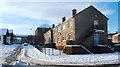
Susannah Street, Alexandria
Susannah Street is on the left. The picture was taken from the corner where it meets James Street.
Image: © Lairich Rig
Taken: 29 Nov 2010
0.01 miles
2
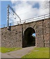
Railway underpass
Image: © Lairich Rig
Taken: 19 Apr 2013
0.04 miles
3
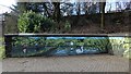
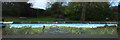
New mural beside the River Leven
This is just part of a much longer mural. For context, see Image, an earlier picture. This detail from the mural is on the section of white wall that is at the back in the earlier picture.
See Image for another detail.
Image: © Lairich Rig
Taken: 13 Mar 2019
0.06 miles
4
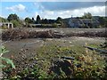
Waste ground by Lennox Street, Alexandria
According to nearby signage, it is to let, for storage. It is bounded by Lennox Street to the west, Alexander Street to the south, North Street to the north (the entrance is on that side), and by the railway line to the east.
(I have specified "Lennox Street, Alexandria" in the title because there is, 2.5 km to the south, another Lennox Street, in Renton.)
Image: © Lairich Rig
Taken: 29 Sep 2017
0.06 miles
5
New mural beside the River Leven
This is just one part of a longer mural; this section shows Image and Image The section out of shot to the right shows Robert the Bruce and a birlinn. The section out of shot to the left shows a fisherman, a heron, Image, and some of the wildlife sustained by the river itself.
For another section, to the photographer's left, see Image For context, see Image, an earlier picture; the section of mural shown in the present picture is on the section of white wall that is, in the earlier picture, just to the left of the red and blue information panels.
See Image for a more distant view of the same area from the other side, likewise taken before the mural was painted.
Image: © Lairich Rig
Taken: 13 Mar 2019
0.07 miles
6
Colquhoun Drive, Rosshead
At the time of the first-edition OS map (c.1860), there were no houses in the area that is now called Rosshead. However, just to the north, in what is now Boathouse Wood, a building called Rosehead stood close to the point where a branch line left the main railway line. It seems likely that Rosehead, with a minor alteration, gave the area its name.
(The branch line mentioned above crossed the River Leven by means of what is now just a Image)
Image: © Lairich Rig
Taken: 29 Nov 2010
0.07 miles
7
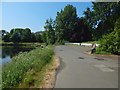
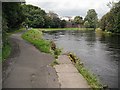
Beside the River Leven
For a view in the opposite direction from about the same place, see Image
In the foreground there is a small car park and the part of the River Leven near Image In front of the houses in the left background is the raised line of the railway. There are some pedestrian tunnels below that line.
Image: © Lairich Rig
Taken: 6 Jun 2018
0.07 miles
8
Linnbrane Hole
Linnbrane Hole is located on the course of the River Leven and is, as the name suggests, a fairly deep part of the river. The water swirls around at this point, with the current on the outside of the bend often directed upstream.
Although it is found with a variety of spellings, the name Linnbrane has long been in use. A 1330 charter by Malcolm, Earl of Lennox, confirms to some monks under the headship of Paisley Abbey "the yare of Linbren" ("le yare de Linbren"), with fishing rights, associated land, and other rights pertaining thereto (a "yare" is a fish-trap in the form of a barrier, where fish could be caught with a net; see Image). An earlier charter, from 1225, had granted the monks similar rights here at "Lynbren".
[Historically, the spelling "Lumbrane" (or similar) is encountered about as often as (and perhaps even more often than) "Linnbrane". My own theory, not necessarily correct, is that this alternative form might have arisen from misreading of manuscripts written in a script where combinations of the letters i/m/n/u are easily confused; this is especially likely to occur when these letters are written as thick vertical strokes joined by much thinner cross-strokes, in which case the letter sequences "inn" (in "Linnbrane") and "um" (in "Lumbrane") both incorporate five consecutive vertical strokes.]
Another nearby place-name has similar ecclesiastical associations: Dalmonach, the "field of the monks"; see Image and Image
See also Image, which shows the same part of the river, but viewed in the opposite direction; the accompanying description preserves another name, "Chapel Hole", associated with the part of the river just below Linnbrane Hole. The name Chapel Hole, though, requires no ancient ecclesiastical explanation; Image is beside that part of the river.
[Anglers can supply many more names for parts of the River Leven, names that have never appeared on an OS map, and hence are all the more worth recording for posterity. They are passed on by word of mouth, and I am not myself an angler, so the following may not be entirely correct; however, I will correct any mistakes that are brought to my attention. A few of the names that have been passed on to me are as follows (working downstream): the Shallows (downstream of Image), Linnbrane Hole, Chapel Hole, the Bridge Pool (just downstream of Image), the Pipes, the Glebe ( http://www.geograph.org.uk/photo/3363458 ), the Piles, the Academy Stream (after Image, and also known as Flowers' Stream, presumably named after the Harry Flowers who was caretaker at the now long-gone mansion called Image), Ritchie's Lade ( http://www.geograph.org.uk/photo/2064160 ), the Pikey, Sandy Hole, the Kennels ( http://www.geograph.org.uk/photo/2064232 ), the Buchs, the Barracks, the Garden Stream ( http://www.geograph.org.uk/photo/1158049 ), and the Boat Hole. See also the end of the item Image]
The present photograph was taken from the cycle route which follows the western side of the river; compare Image, taken from a point only a short distance south along that route.
The old buildings (but not the chimney) visible in the background of the present photograph are Image Those buildings represent only the southern extremity of the print and dye works, which extended for a considerable distance to the north along the riverbank. (The tall chimney is that of Image)
The Croftengea Works were established in that area in 1790, and would become part of the Turkey Red dyeing industry that was once so prominent in the Vale of Leven (see Image for some references). For further information about these works, see http://www.valeofleven.org.uk/valeindustry3.html (at the Vale of Leven website). The Croftengea Works were later amalgamated with the Levenfield Works, just to the north, to form the Alexandria Works.
The Pont/Blaeu map of the Lennox, published in 1654, but based on surveying work carried out in the 1580s-90s, shows the name Kreitagegh (Kreitagech) in this area, on the western side of the Leven. It appears to correspond to the modern "Croftengea"(*).
Some of the housing that was built here for the workers survives: Image See also Image
- - • - -
(*) J.Agnew probably had this in mind when writing, in "The Story of the Vale of Leven" (1976), that "the names of many of these farms still exist and may be recognised: Naperston, Nobleston, Ladyton, Headycks, Milntoun, Overton, Middleton, Tullichoun, Dalwhern, Kreitagech, Millburn".
He does not give their modern equivalents (which are superfluous for local readers), but, aside from Kreitagegh (discussed in more detail below), they are as follows: Napierston (Farm – http://www.geograph.org.uk/photo/2045072 ), Nobleston (see Image), Ladyton (the last two farm names survive as names of the corresponding sections of the large housing estate in Image), Highdykes (Image), Milton (as in Milton Estate, and the former Milton Works, in Jamestown), Overton (Farm), Middleton (the farm's site was in what is now Middleton Street in Alexandria), Tullichewan, Dalquhurn, and Millburn.
"KREITAGEGH" / "CROFTENGEA":
On the face of it, the names Kreitagegh (on Blaeu map) and Croftengea are not very similar. However, an 1841 plan of a proposed Vale of Leven canal provides an intermediate form: on that plan, Croftengea is labelled Croftangeioch.
That accounts for the variant ending, but it still leaves the first part of the name "Kreitagegh" looking like an aberration. However, charter #1250 in the "Calendar of the Laing Charters" sheds some light on that element: that charter dates from 21st October 1592, and its list of witnesses includes "Andrew Dennestoun in Craitingaw".
We thus have an attested early form of the place-name, its first half very similar to that of the Kreitagegh that appears on the Blaeu map; that map, and the names on it, had been based on Pont's earlier surveys, which were carried out in c.1580s-90s, the very period in which that charter was written.
Almost two centuries later, again in the "Calendar of the Laing Charters", there is another record of the place-name: charter #3323 (made in the year 1772) mentions "the two Croftengews".
In the seventeenth century, we have notice of a spelling that is very similar to the one used in recent times: the Dumbarton Common Good Accounts for 1616-17 include several entries related to work on a steeple, and one of them is as follows: "Item geven to John Neaper in Croftingaie for bringing doune the spout staneis to the steipill : vi lib.". Here, "Neaper" is a variation of "Napier" – see Image Also, the "spout staneis" were most probably stone conduits or waterspouts (whether gargoyles or not) for discharging rainwater from the steeple.
Image: © Lairich Rig
Taken: 25 Oct 2010
0.07 miles
9
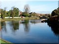
River Leven, Alexandria
The riverside path is used by National Cycle Route 7.
Image: © Richard Webb
Taken: 1 Sep 2009
0.07 miles
10
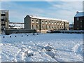
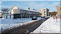
Creveul Court, Alexandria
This building, at Creveul (rhymes with "level") Court, is named after Charles Creveul J.P., and consists of maisonette flats. A similar building 100 metres to the NNW is on McAllister Road (see Image).
The snow-covered but otherwise empty area in the foreground was, until recent years, occupied by the Kippen Dairy. For construction that later took place on that site, see Image and Image, taken five years after the present picture.
Image: © Lairich Rig
Taken: 29 Nov 2010
0.08 miles