IMAGES TAKEN NEAR TO
Gray Street, ALEXANDRIA, G83 0PR
Introduction
This page details the photographs taken nearby to Gray Street, G83 0PR by members of the Geograph project.
The Geograph project started in 2005 with the aim of publishing, organising and preserving representative images for every square kilometre of Great Britain, Ireland and the Isle of Man.

There are currently over 7.5m images from over14,400 individuals and you can help contribute to the project by visiting https://www.geograph.org.uk
Image Map
Images are licensed for reuse under creativecommons.org/licenses/by-sa/2.0
Notes
- Clicking on the map will re-center to the selected point.
- The higher the marker number, the further away the image location is from the centre of the postcode.
Image Listing (147 Images Found)
Images are licensed for reuse under creativecommons.org/licenses/by-sa/2.0
Image
Details
Distance
1
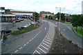
Colquhoun Drive, Rosshead
At the time of the first-edition OS map (c.1860), there were no houses in the area that is now called Rosshead. However, just to the north, in what is now Boathouse Wood, a building called Rosehead stood close to the point where a branch line left the main railway line. It seems likely that Rosehead, with a minor alteration, gave the area its name.
(The branch line mentioned above crossed the River Leven by means of what is now just a Image)
Image: © Lairich Rig
Taken: 29 Nov 2010
0.04 miles
2
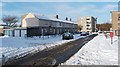
Creveul Court, Alexandria
This building, at Creveul (rhymes with "level") Court, is named after Charles Creveul J.P., and consists of maisonette flats. A similar building 100 metres to the NNW is on McAllister Road (see Image).
The snow-covered but otherwise empty area in the foreground was, until recent years, occupied by the Kippen Dairy. For construction that later took place on that site, see Image and Image, taken five years after the present picture.
Image: © Lairich Rig
Taken: 29 Nov 2010
0.04 miles
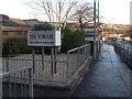
3
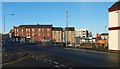
Susannah Street, Alexandria
Susannah Street is on the left. The picture was taken from the corner where it meets James Street.
Image: © Lairich Rig
Taken: 29 Nov 2010
0.05 miles
4
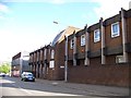
Surgery in Alexandria
Private and NHS surgery on Bank Street.
Image: © Stephen Sweeney
Taken: 6 Dec 2008
0.05 miles
5
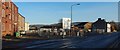
Bank Street looking west
View of Bank Street looking towards the town centre, the large white store at the top of the picture was the co-op now closed.
Image: © George Rankin
Taken: 12 Aug 2002
0.06 miles
6
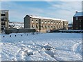
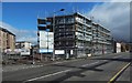
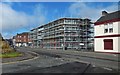
Construction site at Creveul Court
[ˈkɾɛvəɫ] ("KREV-ul").
"22 new homes for social rent ... a mix of flats and accessible bungalows", according to signage on site. Susannah Street recedes from view on the left, and Bank Street on the right. The nearer part of the fenced-off area had until recently been occupied by grass, trees and bushes. See Image for a view from a different angle, from further along Bank Street.
Later picture: Image
Image: © Lairich Rig
Taken: 1 Dec 2019
0.06 miles
7
Construction site at Creveul Court
[ˈkɾɛvəɫ] ("KREV-ul").
The same site is shown from a different angle, from further along Bank Street, in Image; see there for further information. Later picture: Image
Image: © Lairich Rig
Taken: 1 Dec 2019
0.06 miles
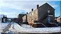
8
Construction site at Creveul Court
[ˈkɾɛvəɫ] ("KREV-ul").
See Image for a view from a different angle, on the same day, and Image for an earlier view from about the same place as the present picture.
Image: © Lairich Rig
Taken: 15 Mar 2020
0.06 miles
9
Construction site at Creveul Court
[ˈkɾɛvəɫ] ("KREV-ul").
See Image for a view from another angle, on the same day, and Image for an earlier view from almost the same place as the present picture.
Image: © Lairich Rig
Taken: 15 Mar 2020
0.06 miles
10
Medical Centre, Bank Street, Alexandria
Image: © Elliott Simpson
Taken: 1 Jun 2013
0.06 miles