IMAGES TAKEN NEAR TO
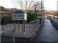
Bank Street, ALEXANDRIA, G83 0NB
Introduction
This page details the photographs taken nearby to Bank Street, G83 0NB by members of the Geograph project.
The Geograph project started in 2005 with the aim of publishing, organising and preserving representative images for every square kilometre of Great Britain, Ireland and the Isle of Man.

There are currently over 7.5m images from over14,400 individuals and you can help contribute to the project by visiting https://www.geograph.org.uk
Image Map
Images are licensed for reuse under creativecommons.org/licenses/by-sa/2.0
Notes
- Clicking on the map will re-center to the selected point.
- The higher the marker number, the further away the image location is from the centre of the postcode.
Image Listing (155 Images Found)
Images are licensed for reuse under creativecommons.org/licenses/by-sa/2.0
Image
Details
Distance
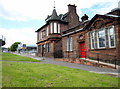
1
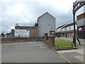
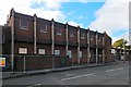
Surgery in Alexandria
Private and NHS surgery on Bank Street.
Image: © Stephen Sweeney
Taken: 6 Dec 2008
0.01 miles
2
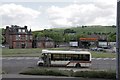
Bank Street looking west
View of Bank Street looking towards the town centre, the large white store at the top of the picture was the co-op now closed.
Image: © George Rankin
Taken: 12 Aug 2002
0.02 miles
3
Colquhoun Drive, Rosshead
At the time of the first-edition OS map (c.1860), there were no houses in the area that is now called Rosshead. However, just to the north, in what is now Boathouse Wood, a building called Rosehead stood close to the point where a branch line left the main railway line. It seems likely that Rosehead, with a minor alteration, gave the area its name.
(The branch line mentioned above crossed the River Leven by means of what is now just a Image)
Image: © Lairich Rig
Taken: 29 Nov 2010
0.03 miles
4
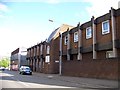
Old Post office
The former Post office and the Vale of Leven Constitutional Club Building at Bank Street Alexandria
The Aldi store stands on the site of the old Strand Cinema.
The new road has been re routed to form a roundabout and the old road used to be situated alongside these buildings
Image: © Eddie Mackinnon
Taken: 13 May 2007
0.04 miles
5
Medical Centre, Bank Street, Alexandria
Image: © Elliott Simpson
Taken: 1 Jun 2013
0.04 miles
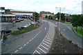
6
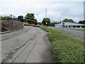
Service road beside Bank Street (B857) in Alexandria
Looking north-westward.
Image: © Peter Wood
Taken: 25 Jul 2020
0.05 miles
7
View of Bank Alexandria
A new view of Bank St towards the Railway bridge now the foot bridges have been removed in March 2010
Image: © Eddie Mackinnon
Taken: 26 May 2010
0.05 miles
8
Mitchell Way, Alexandria
Compare an earlier picture: Image The building on the left in that view has been demolished; see also Image
Image: © Lairich Rig
Taken: 21 Aug 2016
0.05 miles
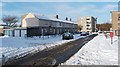
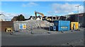
9
Medical Centre in Bank Street being demolished
Demolition of the former Image was underway when this picture was taken. For views from the back, see Image and Image
For a later view, see Image
Image: © Lairich Rig
Taken: 23 Oct 2016
0.06 miles
10
Medical Centre in Bank Street being demolished
The view is from the part of the road that appears at the far right in Image Much of the facade on Bank Street was still intact: Image
For a later view, see Image
Image: © Lairich Rig
Taken: 23 Oct 2016
0.06 miles