
IMAGES TAKEN NEAR TO
King Edward Street, ALEXANDRIA, G83 0EJ
Introduction
This page details the photographs taken nearby to King Edward Street, G83 0EJ by members of the Geograph project.
The Geograph project started in 2005 with the aim of publishing, organising and preserving representative images for every square kilometre of Great Britain, Ireland and the Isle of Man.

There are currently over 7.5m images from over14,400 individuals and you can help contribute to the project by visiting https://www.geograph.org.uk
Image Map
Images are licensed for reuse under creativecommons.org/licenses/by-sa/2.0
Notes
- Clicking on the map will re-center to the selected point.
- The higher the marker number, the further away the image location is from the centre of the postcode.
Image Listing (138 Images Found)
Images are licensed for reuse under creativecommons.org/licenses/by-sa/2.0
Image
Details
Distance
2
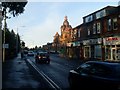
North Main Street, Alexandria
Looking north to the Factory Outlets.
Image: © Stephen Sweeney
Taken: 6 Dec 2008
0.06 miles
3
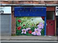
New mural in Alexandria
The mural is by Barry the Cat. A few minutes earlier, my attempt to photograph another of his recent artworks was foiled by a vehicle parked in front of the building; however, a helpful taxi driver pointed out that another mural (this one) had recently been completed by the same artist a little further to the north along Main Street.
The building is opposite the north-eastern corner of the Christie Park, and is near the junction of Main Street and King Edward Street.
When I headed back along Main Street, after taking this picture, I found that the mural I originally intended to photograph was no longer blocked from view: Image
Image: © Lairich Rig
Taken: 11 Sep 2016
0.06 miles
4
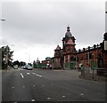
Factory retail outlet in Alexandria
This magnificent building was originally built for the Argyll car manufacturers. For a more detailed description see Image]
Image: © James Denham
Taken: 18 Sep 2014
0.07 miles
5
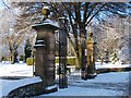
Main gates of Christie Park
See Image for a view from beside another entrance to the park.
Christie Park was officially opened on the 5th of July, 1902. Mrs Christie ceremonially opened the gates of the new park with a golden key; see Image for further details about the park, its opening, and its donor.
These gates are at the far end of the footpath that is visible on the right in Image
Image: © Lairich Rig
Taken: 30 Nov 2010
0.07 miles
6
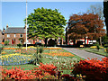
Christie Park Alexandria
View from inside Christie Park looking towards the front gates at main street Alexandria
Image: © Eddie Mackinnon
Taken: 5 May 2005
0.07 miles
7
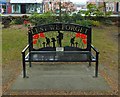
War Memorial Bench, Christie Park
The War Memorial itself is behind the photographer: Image This new bench is near the spot from which Image was taken. The plaque reads:
"This commemorative bench is a gift to the people of West Dunbartonshire from the Dunbartonshire Argyll Somme Association in lasting memory of all those who made the ultimate sacrifice in defence of our country. Lest we forget."
Compare Image (Dumbarton) and Image (Gourock).
Image: © Lairich Rig
Taken: 16 May 2019
0.08 miles
8
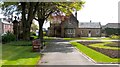
Christie Park
This is the south-eastern corner of the park; the Image are visible on the left. The building that is visible ahead was originally the keeper's lodge (at the Image); like the main gates, the lodge was the work of the architect James Miller. An inscription on its eastern wall describes the circumstances of the park's creation: Image
Image: © Lairich Rig
Taken: 21 May 2012
0.08 miles
9
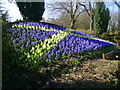
Patriotic flowerbed
A spring saltire flowerbed in Christie Park.
Image: © Mark Nightingale
Taken: 15 Apr 2010
0.08 miles
10
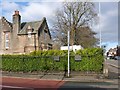
Corner of Park Street and Main Street
Image is in the foreground. The Christie Park is in the foreground. The building at the left was originally the park keeper's lodge: Image
The two plaques on the fence railings refer to a special pipe installed for the United Turkey Red Company in 1926: Image
Image: © Lairich Rig
Taken: 6 Feb 2013
0.08 miles