
IMAGES TAKEN NEAR TO
Park Street, ALEXANDRIA, G83 0DT
Introduction
This page details the photographs taken nearby to Park Street, G83 0DT by members of the Geograph project.
The Geograph project started in 2005 with the aim of publishing, organising and preserving representative images for every square kilometre of Great Britain, Ireland and the Isle of Man.

There are currently over 7.5m images from over14,400 individuals and you can help contribute to the project by visiting https://www.geograph.org.uk
Image Map
Images are licensed for reuse under creativecommons.org/licenses/by-sa/2.0
Notes
- Clicking on the map will re-center to the selected point.
- The higher the marker number, the further away the image location is from the centre of the postcode.
Image Listing (124 Images Found)
Images are licensed for reuse under creativecommons.org/licenses/by-sa/2.0
Image
Details
Distance
1
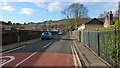
Park Street, Alexandria
The picture was taken from the junction with Main Street. To the left, behind the wall, are the lawn bowling greens of the Vale of Leven Bowling Club.
To the right, the fence is the boundary of the Christie Park; the building at the far right was originally the park keeper's lodge: see Image Just to the right of the photographer's position, a couple of old plaques are affixed to the railings; see Image and Image
See Image for a view back from the far end of the street.
Image: © Lairich Rig
Taken: 6 Feb 2013
0.05 miles
2
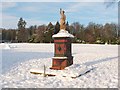
Drinking fountain, Christie Park
The long-disused fountain is located just within the southern entrance of the Christie Park in Alexandria. The figure's uplifted arm originally held an urn aloft.
The park was named after a local industrialist in the dyeing and textiles industry, John Hyde Christie (chairman of United Turkey Red Co Ltd.), who gifted the park to the district: see Image for the details.
For the date when the park was officially opened, see Image
For a selection of pictures taken in the park, see Image / Image / Image / Image / Image
Image: © Lairich Rig
Taken: 29 Nov 2010
0.05 miles
3
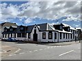
Hill Street, Alexandria, West Dunbartonshire
Located on the corner of Hill Street and Middleton Street this former police station built in the 1930s had become a local landmark in Alexandria, Dunbartonshire.
After closing its doors to the public in 2013 it fell into disrepair. It has since been transformed into six new homes by Bingham Homes.
Image: © George Rankin
Taken: 5 Apr 2021
0.08 miles
4
Park Street, Alexandria
The picture was taken from the junction with Middleton Street (Image). The Christie Park is on the left: Image
One of the entrances of the park is located out of shot, just to the left of the photographer's position; a drinking fountain topped with a statue is located there: Image
Image: © Lairich Rig
Taken: 29 Nov 2010
0.08 miles
5
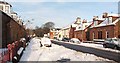
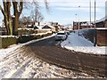
Middleton Street, Alexandria
The picture was taken from near the junction with Gilmour Street (Image). The trees at the far end of the street are in the Christie Park (Image).
For a photograph taken at roughly the same place, looking in the opposite direction, see Image
Image: © Lairich Rig
Taken: 29 Nov 2010
0.09 miles
6
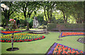
Christie Park Alexandria
taken towards War Memorial
Image: © Eddie Mackinnon
Taken: 11 Jul 2006
0.10 miles
7
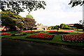
Christie Park Alexandria
Flower Beds at Christie Park Alexandria
Image: © Eddie Mackinnon
Taken: 11 Jul 2006
0.10 miles
8
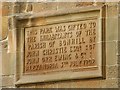
Christie Park: inscription on the lodge
For context, see Image, which shows the building (originally the park keeper's lodge) on which this inscription is carved. The text appears on the eastern wall (the side facing the main road), and is as follows (reproduced here so that it can be found by searches):
"This park was gifted to the inhabitants of the parish of Bonhill by John Christie Esqr. of John Orr Ewing & Co : Alexandria 5th July 1902".
In order to create the park, Christie purchased (in 1900) what had formerly been known as Notman's Park, and the area of woodland behind it. In 1902, he made known his intentions to donate the park to the parish, and to provide the sum of £2000 for its upkeep. However, see the entry for "Christie Park" at http://www.valeofleven.org.uk/scottishplacenames/Cvale_names.html (at the Vale of Leven website) for the actual source of the money used to fund the park's creation.
The park was officially opened on the date mentioned on the inscription; a procession was part of the festivities. At three in the afternoon, Mrs Christie (née Jessie Fulton – see below) opened the Image using a golden key. By that time, not everything had yet been completed: the bandstand (no longer present – see below) had not been painted, a shelter had not been erected, and the proposed woodland paths at the back of the park had not been created (in the meantime, the public were asked not to wander off into the woods).
The park was laid out in accordance with designs by Mr Whitton (James Whitton, superintendent of Glasgow Parks); these designs were carried out by a certain Mr J Leith of Rothesay.
In 1952 the park's 50th Jubilee was celebrated here. The Christie Park Veterans' Bowling Club had their green and club house within the park from 1916 onwards (they are now located nearby). As mentioned above, there was originally a bandstand within the park; it was sold off in the 1980s, supposedly to be re-erected elsewhere.
The donor of the park is sometimes referred to as John Christie of Gallangad. He was John Hyde Christie, born at Barrhead (Image) in 1836. He studied chemistry at Glasgow, and was first employed by his cousin's firm, Hay and Hyde, silk manufacturers and dyers at Port Dundas (Image). In 1859 he left to take up the post of chemist at John Orr Ewing and Company's Alexandria Works (see Image and Image for the remnants of the buildings).
He became assistant manager of the works fifteen years later, and then manager. In 1878 he became a partner in the firm. In 1898 several firms (John Orr Ewing & Co, Archibald Orr Ewing & Co, and William Stirling & Sons) amalgamated to form the United Turkey Red Company Ltd., and Christie became chairman of the combined operation. He held that position until 1922, when he retired (his eldest son Henry William Christie succeeded him as UTRC chairman). John Christie was also interested in the production of synthetic dyes, and was a director of the British Alizarine Company.
In 1872 he married Jessie Fulton, the third daughter of the farmer John Fulton. Christie purchased the Gallangad estate (Image) from Mr Cunningham Graham in 1895, and the adjoining Croftfoot (Image) in the following year. Mrs Christie died in 1924, and her husband died in 1926 at his Alexandria residence of Levenfield [the biographical information above is taken from his obituary in the Lennox Herald].
Image: © Lairich Rig
Taken: 21 May 2012
0.10 miles
9
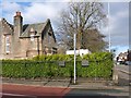
Corner of Park Street and Main Street
Image is in the foreground. The Christie Park is in the foreground. The building at the left was originally the park keeper's lodge: Image
The two plaques on the fence railings refer to a special pipe installed for the United Turkey Red Company in 1926: Image
Image: © Lairich Rig
Taken: 6 Feb 2013
0.11 miles
10
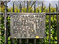
Plaque on fence of Christie Park
See Image for context. Of the two plaques visible there, this is the one on the left; the other one is not worth showing separately, since the wording is the same, except that "STOP VALVE 7¾ FT" is replaced by "AIR VALVE 25 FEET".
The meaning of the abbreviations will be clear enough to people from the area, but for the benefit of other readers: "V.L.W.W." – Vale of Leven Water Works; "U.T.R.Co" – United Turkey Red Company.
The UTR Company was one of the two main amalgamations of textile and dyeing works in the Vale of Leven. The other group came under the control of the Manchester-based Calico Printers Association. The UTR was formed in 1897, partly in an attempt to resist takeover by the parent organisation of the CPA; the CPA would eventually take over the assets of the UTR Company in 1960, and fairly soon afterwards they closed the local UTR works. These matters are discussed in much more detail at http://www.valeofleven.org.uk/valeindustry.html (Vale of Leven website).
Image: © Lairich Rig
Taken: 6 Feb 2013
0.11 miles