IMAGES TAKEN NEAR TO
Victoria Street, ALEXANDRIA, G83 0AH
Introduction
This page details the photographs taken nearby to Victoria Street, G83 0AH by members of the Geograph project.
The Geograph project started in 2005 with the aim of publishing, organising and preserving representative images for every square kilometre of Great Britain, Ireland and the Isle of Man.

There are currently over 7.5m images from over14,400 individuals and you can help contribute to the project by visiting https://www.geograph.org.uk
Image Map
Images are licensed for reuse under creativecommons.org/licenses/by-sa/2.0
Notes
- Clicking on the map will re-center to the selected point.
- The higher the marker number, the further away the image location is from the centre of the postcode.
Image Listing (99 Images Found)
Images are licensed for reuse under creativecommons.org/licenses/by-sa/2.0
Image
Details
Distance
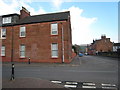
1
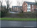
Housing in Alexandria
Looking along Arthur Street from the B857.
Image: © Stephen Sweeney
Taken: 6 Dec 2008
0.02 miles
2
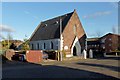
Alexandria Methodist Church
The church (1877-78) stands alongside Albert Street in Alexandria.
Image: © Lairich Rig
Taken: 27 Nov 2012
0.04 miles
3
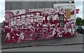
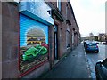
A new mural on the Old Vale Bar
The bar is at the corner of Main Street and Albert Street, and the art is by Barry the Cat. I am grateful to the person from the bar who took the time to explain the details to me on the day.
The mural was painted in such a way as not to clash with the existing colour scheme of the bar. Among the local worthies, past and recent, commemorated in it are Tobias Smollett, at the lower-left corner (Image / Image), and Skeets Gallacher, at the far right (Image).
Long ago, a horse could put its head through a hatch in the side of the building to feed from a bucket; the artwork alludes to this. That hatch is now a window (appropriately, the one with the horse painted around it).
Image: © Lairich Rig
Taken: 17 Jun 2018
0.04 miles
5
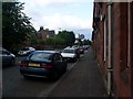
Main Street, Alexandria
I had hoped to get a better view of the artwork in the left foreground, but the grey car parked in front made that impossible. The red sandstone buildings themselves were originally called Mulberry Bank, and they date from 1887.
The location is at the corner of Main Street and Arthur Street. The red sandstone buildings continue to the north, becoming progressively older: those on the other side (north) of Arthur Street date from 1885; Dalmary Place dates from 1884; north of Albert Street is Plane Tree Bank (undated).
Image: © Lairich Rig
Taken: 26 Dec 2017
0.05 miles
7
Queen Street Alexandria
taken from Upper bridge Street and Queen Street junction
Image: © Eddie Mackinnon
Taken: 23 Mar 2007
0.09 miles
8
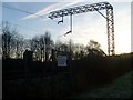
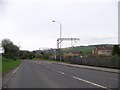
Railway lines by the B857
In Alexandria.
Image: © Stephen Sweeney
Taken: 6 Dec 2008
0.09 miles
9
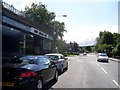
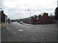
Car showroom, Main Street, Alexandria
Right on the corner of Main Street before it meets with and becomes the B857.
Image: © Stephen Sweeney
Taken: 17 Aug 2008
0.09 miles
10
Upper Bridge Street Alexandria
Upper Bridge Street Alexandria from the Junction of Middleton Street and Queen Street
Image: © Eddie Mackinnon
Taken: 23 Mar 2007
0.10 miles