IMAGES TAKEN NEAR TO
Braid Drive, DUMBARTON, G82 5QD
Introduction
This page details the photographs taken nearby to Braid Drive, G82 5QD by members of the Geograph project.
The Geograph project started in 2005 with the aim of publishing, organising and preserving representative images for every square kilometre of Great Britain, Ireland and the Isle of Man.

There are currently over 7.5m images from over14,400 individuals and you can help contribute to the project by visiting https://www.geograph.org.uk
Image Map
Images are licensed for reuse under creativecommons.org/licenses/by-sa/2.0
Notes
- Clicking on the map will re-center to the selected point.
- The higher the marker number, the further away the image location is from the centre of the postcode.
Image Listing (58 Images Found)
Images are licensed for reuse under creativecommons.org/licenses/by-sa/2.0
Image
Details
Distance
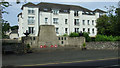
1
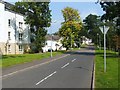
Braid Drive
This is part of the Fairways housing development in Cardross. The houses had only recently been built when this picture was taken, and they are located beside Cardross Golf Course.
The houses to the left of Braid Drive occupy what was formerly Cardross Park; the park had two lodges on the main road, and a mansion house further to the north.
Image: © Lairich Rig
Taken: 3 Sep 2010
0.05 miles
2
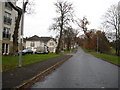
Braid Drive in Cardross
In Argyll and Bute.
Image: © James Denham
Taken: 24 Nov 2013
0.09 miles
3
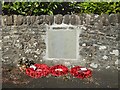
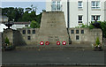
Memorial to Reginald Graham VC, Cardross
When this picture was taken, the stone had only very recently been unveiled. It honours a local (Cardross) man who was a recipient of the Victoria Cross. The stone has been set in the wall just to the right of Image; relative to that picture, it would be at the right-hand edge.
The stone has a representation of a Victoria Cross (complete with its inscribed text "For Valour"). Below that is the following inscription:
"Lieutenant
Reginald Graham
Argyll and Sutherland
Highlanders
22nd April 1917"
For further information about his life, see http://www.helensburgh-heritage.co.uk/index.php?view=article&id=950 (at Helensburgh Heritage).
Image: © Lairich Rig
Taken: 5 May 2017
0.10 miles
4
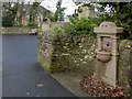
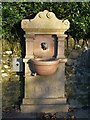
Old drinking fountain
The old fountain is dated 1902, and bears an ER monogram (for Edward VII).
The present photograph shows it in context, with Image behind it; see Image for a closer view.
Image: © Lairich Rig
Taken: 1 Feb 2013
0.10 miles
5
Old drinking fountain
This fountain stands beside Main Road, immediately to the south-east of the War Memorial (Image), as is made clear in another view: Image
An ER insignia (with a crown) is carved into the headpiece; this presumably denotes Edward VII, since the base of the fountain is dated 1902.
Image: © Lairich Rig
Taken: 29 Dec 2008
0.10 miles
6
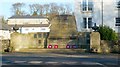
Cardross War Memorial
See Image for another view.
Image: © Lairich Rig
Taken: 29 Dec 2008
0.10 miles
7
Cardross War Memorial
On Main Road at Station Road.
Image: © Thomas Nugent
Taken: 12 Jul 2013
0.11 miles
8

Cardross War Memorial
See Image for another view.
Image: © Lairich Rig
Taken: 1 Feb 2013
0.11 miles
9
Cardross War Memorial
On Main Road at Station Road.
Image: © Thomas Nugent
Taken: 12 Jul 2013
0.11 miles
10
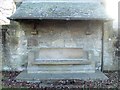
Rural Seat
The seat is shown in context, with further details, here: Image
Note, on the back of the seat, a small carved symbol: Image
Image: © Lairich Rig
Taken: 29 Dec 2008
0.11 miles