IMAGES TAKEN NEAR TO
Mill Road, DUMBARTON, G82 5PQ
Introduction
This page details the photographs taken nearby to Mill Road, G82 5PQ by members of the Geograph project.
The Geograph project started in 2005 with the aim of publishing, organising and preserving representative images for every square kilometre of Great Britain, Ireland and the Isle of Man.

There are currently over 7.5m images from over14,400 individuals and you can help contribute to the project by visiting https://www.geograph.org.uk
Image Map
Images are licensed for reuse under creativecommons.org/licenses/by-sa/2.0
Notes
- Clicking on the map will re-center to the selected point.
- The higher the marker number, the further away the image location is from the centre of the postcode.
Image Listing (143 Images Found)
Images are licensed for reuse under creativecommons.org/licenses/by-sa/2.0
Image
Details
Distance
1
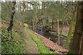
Path beside the Geilston Burn
Part of one of the woodland walks.
Image: © Richard Sutcliffe
Taken: 1 Apr 2024
0.07 miles
2
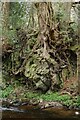
Clinging on
The roots of an oak tree and the ivy that is growing on it both cling on to the rocks beside the Geilston Burn.
Image: © Richard Sutcliffe
Taken: 1 Apr 2024
0.07 miles
3
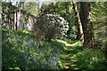
Woodland Walk Geilston house
Shady walk along burn at Geilston at springtime
Image: © Eddie Mackinnon
Taken: 27 Apr 2007
0.08 miles
6
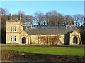
Geilston Halls
Built from 1889-90 (Honeyman and Keppie), this building is used for various community functions. It is viewed here from Main Road.
The building replaces an earlier structure which was built by the Geils family (of Geilston), and which was destroyed by fire. An inscription on a gable-head (the one above the entrance on the right) reads "erected 1889 in memory of JTG": Image On the person commemorated there, see Image and Image The inscription above the entrance on the left is simply "The Geilston Hall".
See Image for another picture of the building.
Image: © Lairich Rig
Taken: 29 Dec 2008
0.09 miles
7
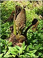
Gunnera at Geilston Garden
The developing flower spike and leaves of a Gunnera manicata look quite alien in appearance.
Image: © Richard Sutcliffe
Taken: 7 May 2021
0.10 miles
8
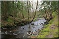
The Geilston Burn
The burn flows through the NTS garden.
Image: © Richard Sutcliffe
Taken: 1 Apr 2024
0.10 miles
9
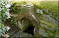
Old wellhead, Geilston Gardens
The well is located within Geilston Gardens, beside one of the footpaths that closely follow the Geilston Burn in the area to the south and east of Image
The inscription on the old wellhead is as follows: "10th March 1863 I.T.G. & H.E.G.". The well is shown a couple of decades later in Image
I could find no source providing any details about whose initials are on the well. However, I believe the initials to be those of Joseph Tucker Geils and his wife Hester Elizabeth Geils: see Image
(An aside: another well, located about two miles from here, at Ardmore Point, has a similar appearance; this is probably, in part, because it likewise has a connection to the Geils family: Image)
In that connection, a gable-head at nearby Image has the inscription "erected 1889 in memory of JTG", which almost certainly commemorates the same Joseph T Geils: Image
He had a military career in India, as did more than one of his forebears.
The Geils family owned Geilston from around the start of the nineteenth century. However, the place-name is much older; the family did not give their name to the place, although it is possible that the spelling of their surname resulted in the place-name's spelling being fixed in a similar form: see Image For more on the Geils family, see the link just given, and Image
Image: © Lairich Rig
Taken: Unknown
0.10 miles
10
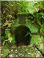
Old wellhead, Geilston Garden
This wellhead in a corner beside the path has become some what overgrown since it was photographed in 2001 Image, but it is still possible to make out the inscription:
10th MARCH
1863
I.T.G.
&
H.E.G.
Image: © Richard Sutcliffe
Taken: 13 Aug 2020
0.10 miles