IMAGES TAKEN NEAR TO
Hillside Road, DUMBARTON, G82 5LU
Introduction
This page details the photographs taken nearby to Hillside Road, G82 5LU by members of the Geograph project.
The Geograph project started in 2005 with the aim of publishing, organising and preserving representative images for every square kilometre of Great Britain, Ireland and the Isle of Man.

There are currently over 7.5m images from over14,400 individuals and you can help contribute to the project by visiting https://www.geograph.org.uk
Image Map
Images are licensed for reuse under creativecommons.org/licenses/by-sa/2.0
Notes
- Clicking on the map will re-center to the selected point.
- The higher the marker number, the further away the image location is from the centre of the postcode.
Image Listing (13 Images Found)
Images are licensed for reuse under creativecommons.org/licenses/by-sa/2.0
Image
Details
Distance
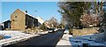
1
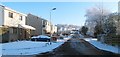
Kilmahew Avenue, Cardross
The photograph was taken from the western end of the street, at its junction with Image
Image: © Lairich Rig
Taken: 23 Dec 2010
0.19 miles
2
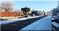
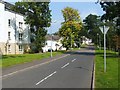
Muirend Road, Cardross
The photograph was taken from the western end of the street, at the junction with Barrs Road.
Image: © Lairich Rig
Taken: 23 Dec 2010
0.21 miles
3
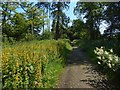
Path beside a golf course
The path passes between two parts of the golf course of Cardross Golf Club. The flowers on the left are Image, which often seems to be confused with Image
Image: © Lairich Rig
Taken: 12 Jul 2019
0.22 miles
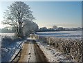
4
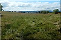
Field beside Barrs Road
The view is from Barrs Road; compare Image, from further along it. The houses that are on the left in that picture, and in the background of this one, are on Kilmahew Avenue. The hills in the background are on the other side of the Clyde.
Image: © Lairich Rig
Taken: 12 Jul 2019
0.22 miles
5
Braid Drive
This is part of the Fairways housing development in Cardross. The houses had only recently been built when this picture was taken, and they are located beside Cardross Golf Course.
The houses to the left of Braid Drive occupy what was formerly Cardross Park; the park had two lodges on the main road, and a mansion house further to the north.
Image: © Lairich Rig
Taken: 3 Sep 2010
0.23 miles
6
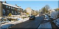
Barrs Road, Cardross
Image: © Lairich Rig
Taken: 23 Dec 2010
0.24 miles
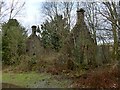
7
Remains of the West Lodge
For a view of the whole ruin from the other side, see Image Click on the end-note title for other views.
Image: © Lairich Rig
Taken: 1 Feb 2013
0.24 miles
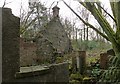
8
Remains of the West Lodge
See Image for the interior, viewed from the other side. Click on the end-note title for other views of the building.
Image: © Lairich Rig
Taken: 1 Feb 2013
0.24 miles
9
Barrs Road, Cardross
Ahead, at the entrance gate of a driveway, Kirkton Road branches off to the left. Barrs Road continues to the north, beyond the area of housing: see Image, which also explains the road's name.
Image: © Lairich Rig
Taken: 23 Dec 2010
0.24 miles
10
Barrs Road
The photograph was taken from the same spot as Image, but is a view in the opposite direction along the road, which, as viewed in the present image, leads into Cardross.
At the far end of the field to the left of the road, the backs of houses in Image are visible. The buildings on the right are alongside Kirkton Road (see Image).
The same section of road, as viewed from the other end, is shown in Image; the origin of the road's name is also explained there.
Image: © Lairich Rig
Taken: 23 Dec 2010
0.25 miles