IMAGES TAKEN NEAR TO
Muirend Road, DUMBARTON, G82 5LG
Introduction
This page details the photographs taken nearby to Muirend Road, G82 5LG by members of the Geograph project.
The Geograph project started in 2005 with the aim of publishing, organising and preserving representative images for every square kilometre of Great Britain, Ireland and the Isle of Man.

There are currently over 7.5m images from over14,400 individuals and you can help contribute to the project by visiting https://www.geograph.org.uk
Image Map
Images are licensed for reuse under creativecommons.org/licenses/by-sa/2.0
Notes
- Clicking on the map will re-center to the selected point.
- The higher the marker number, the further away the image location is from the centre of the postcode.
Image Listing (49 Images Found)
Images are licensed for reuse under creativecommons.org/licenses/by-sa/2.0
Image
Details
Distance
1

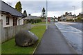
Muirend Road, Cardross
The photograph was taken from the western end of the street, at the junction with Barrs Road.
Image: © Lairich Rig
Taken: 23 Dec 2010
0.09 miles
2

Barrs Terrace and Barrs Road, Cardross
Image: © Lairich Rig
Taken: 23 Dec 2010
0.13 miles
3
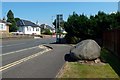
Main Road through Cardross
For the large stone and the plaque on it, see Image, a view in the opposite direction.
Image: © Lairich Rig
Taken: 13 Jul 2018
0.13 miles
4
Interpretation panel at Cardross
This is the point where Park Terrace branches off from the Main Road. The panel is, like the one shown in Image, associated with the Clyde Sea Lochs Trail. This one is about the village of Cardross.
Image: © Lairich Rig
Taken: 11 Nov 2016
0.13 miles
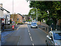
5
Main Street, Cardross
The A814 through Cardross.
Image: © Barbara Carr
Taken: 18 Apr 2013
0.13 miles
7
Main Road through Cardross
Image (Image) is in the background, on the right.
The stone visible just ahead bears a plaque (Image), erected in 2000, with a brief commentary on the Napiers; specifically, on the Napiers of Kilmahew (on whom, see Image) and the Napiers of Merchiston. For example, it states that John Napier of logarithm fame was of the Merchiston Napiers (it does not mention the Robert Napier who is sometimes called the Father of Clyde Shipbuilding – see Image – but, judging by his heraldic arms at least, he appears to have been of the Kilmahew Napiers).
Not far beyond the stone is the entrance to an area of housing called Scott Gardens, named after Cardross man William Stein Scott, a campaigner for social housing.
See Image for a view in the opposite direction.
Image: © Lairich Rig
Taken: 1 Feb 2013
0.14 miles
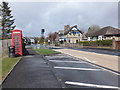
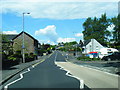
8
Main Road, Cardross
Cardross (Scottish Gaelic: Càrdainn Ros) is a large village on the north side of the Firth of Clyde, situated halfway between Dumbarton and Helensburgh.
Image: © David Dixon
Taken: 26 Sep 2019
0.14 miles
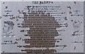
10
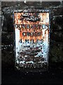
Old milestone in Cardross
This milestone is shown on the first edition of the 1:10560 OS map, surveyed in 1857, and is showing its age, but the text can still be read; it is more legible in a picture taken seven years later, after the milestone had been repainted: Image
←
DUNBARTON
CROSS
4 MILES
→
HELENSBURGH
4 MILES
I have called this a milestone, although it is really a piece of iron. This one is set in front of a wall; other milestones on the same road are of the same kind, and have had short sections of wall built behind them: Image and Image
Image: © Lairich Rig
Taken: 13 Nov 2009
0.15 miles