IMAGES TAKEN NEAR TO
Carman Road, DUMBARTON, G82 5JZ
Introduction
This page details the photographs taken nearby to Carman Road, G82 5JZ by members of the Geograph project.
The Geograph project started in 2005 with the aim of publishing, organising and preserving representative images for every square kilometre of Great Britain, Ireland and the Isle of Man.

There are currently over 7.5m images from over14,400 individuals and you can help contribute to the project by visiting https://www.geograph.org.uk
Image Map
Images are licensed for reuse under creativecommons.org/licenses/by-sa/2.0
Notes
- Clicking on the map will re-center to the selected point.
- The higher the marker number, the further away the image location is from the centre of the postcode.
Image Listing (108 Images Found)
Images are licensed for reuse under creativecommons.org/licenses/by-sa/2.0
Image
Details
Distance
1
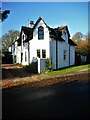
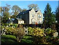
The White House
A late 18th-early 19th century house with later 19th century additions. It is situated at the corner of Main Road (A814) and Carman Road. Originally called Bainfield House, this name is now associated with another nearby property Image It is Category C listed http://portal.historicenvironment.scot/designation/LB1153.
Image: © Richard Sutcliffe
Taken: 4 Nov 2022
0.02 miles
2
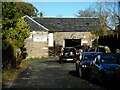
Burnhill Motors
Now a garage, the building was originally a corn mill and dates from 1818. It is Category C listed http://portal.historicenvironment.scot/designation/LB43882.
Image: © Richard Sutcliffe
Taken: 4 Nov 2022
0.03 miles
3
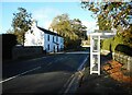
A814, Cardross
Looking north. Bainfield House is on the left.
Image: © Richard Sutcliffe
Taken: 4 Nov 2022
0.04 miles
5

Cardross old parish Church
Ruin of old Parish Church which was bombed in 1941. The tower remains.
Image: © J M Briscoe
Taken: 7 May 2005
0.05 miles
6
Cardross Manse
Next to the former parish church. A Category C listed building https://britishlistedbuildings.co.uk/200330335-cardross-manse-cardross#.Y2WVHUzP1PY, dating from the earlier 19th century with later alterations in 1869-70 and 1897.
Image: © Richard Sutcliffe
Taken: 4 Nov 2022
0.05 miles
7
Commonwealth War Grave, Cardross
1472229 GUNNER
W. McMANUS
97TH HEAVY A.A. REGT. R.A.
LONDON SCOTTISH
27TH SEPTEMBER 1941 AGE 19
NEARER MY GOD TO THEE
William McManus, 97 (3rd Battalion, The London Scottish) Heavy Anti-Aircraft, Royal Artillery, was the son of Samuel and Janet McManus, of Cardross.
Image: © Richard Sutcliffe
Taken: 4 Nov 2022
0.06 miles
8
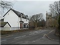
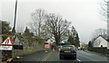
Cardross
Entering the village from the east.
Image: © Stephen Sweeney
Taken: 26 Feb 2012
0.06 miles
9
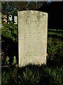
The gravestone of John Traquair
The churchyard of Image contains some imposing monuments and burial grounds, particularly in its northern and north-eastern extremities. See for example, Image, the Image, the Image, and the Image
However, the churchyard is primarily rural in character, and many of the stones display the names of local farms. Some of those names still appear on maps, while others will be less familiar to many modern readers. To give a more representative view of the churchyard, I have pictured a few of the memorials associated with local farmers; for the others, see Image (of Claddoch), Image (of Wester Ardoch), and Image (of Hawthornhill).
The pits on this and nearby stones were caused by shrapnel; Image was damaged in the Cardross Blitz of 1941.
The stone shown in the present photograph commemorates John Traquair, farmer at Clydebank, who died on the 5th of June 1876, aged 72; his wife Geils Goldie, who died on the 26th of January 1891, aged 90; and some of their family.
Traquair is one of several surnames that have a very long association with the Cardross area [see comments on page 16 of Arthur F Jones' "Cardross: the Village in Days Gone By" (1985)].
The Clydebank at which John Traquair was a farmer is not the well-known town of that name(*); instead, it was a farmstead centred on Image, about 2.7 km ESE of here, near the shore. The Farm Horse Tax Rolls of 1797-98 show that a Mr Robert McKenzie was then the farmer at Clydebank. He was apparently the first, because David Murray, in his "Old Cardross" (1880), describes the farm of Clydebank as "having been cut out of the surrounding land at the end of the last century by Mr Robert McKenzie, who was then factor on the Ardoch Estate. It is made up of one of the Lies, the old Fir Park and Plover Bog, part of the Six Acres Farm ... and the ground on the shore called Clerkhill park. The field in which the house was built was part of the farms of Havock and Hawthornhill".
On some of the names mentioned above, see Image, Image, and Image (for Ardoch and for "the Lies", pron. [liːz]).
[(*) In the 1870s, when John Traquair died, there was not, as yet, a "town of Clydebank" (c.Image), although a settlement had already begun to develop there. The Burgh of Clydebank was not formed until 1886, and it took its name from J & G Thomson's Clydebank shipyard at Barns of Clyde – see Image for further details.]
Image: © Lairich Rig
Taken: 18 Jan 2013
0.06 miles
10
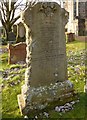
Memorial to John Edmonstone
This white marble tablet (or rather its predecessor — see the end of this description) was erected in June 1772; it is set in the south-west wall (the side nearest the main road) of the churchyard of Image
- - • - -
M.S.
ad hoc marmor depositae sunt reliquiae
viri plurimum reverendi doctissimique
JOANNIS EDMONSTONE A.M. V.D.M.
qui in parochia de Cardross per annos quater undecim
pastoris praestantissimi muneribus functus est.
ab adolescentia studiis optimarum artium deditus
verum et honestum sensit, coluit, commendavit.
rerum divinarum humanarumque scientia, inter paucissimos, excultus.
erga summum numen pietatem, erga genus humanum amorem,
in concionibus, in congressibus, voce multum, vita magis,
docuit.
ab initiis officiis adusque vitae finem firmus atque stabilis
virtutis verae pacifique Christianae custos et satelles.
in rudiores hallucinantes devios mitis et misericors:
etiam in turbulentos et pervicaciter rixantes vix acerbus.
mensis Martii XXI anno MDCCLXXI,
annis gravis, pietate gravissimus,
mortem sensibus placidissimus obiit octogenarius.
Andreas filius natu maximus parenti optimo moerens posuit.
V.S.L.M. Restored in 1938.
- - • - -
The Latin text of this inscription can be found in several old books, cited at the end of this item. They all differ to some extent from the actual inscription. I've attempted to reproduce exactly what is on the stone.
(1) A.M.: "artium magister" (the academic qualification M.A.).
(2) V.D.M.: "verbi dei minister", "minister of the word of God"; broadly equivalent to "the Reverend".
(3) V.S.L.M. ("votum solvit libens merito"): a votive formula that appeared on the base of some Roman altars, etc.
It is not worth giving the full translation of the inscription here, since it provides very little in the way of biographical details, other than that John Edmonstone performed the duties of a pastor in this parish for 44 ("quater undecim", 4 × 11) years; that he died on the 21st of March 1771, in his 80th year; and that the stone was erected by his eldest son Andrew (on whom, see Image).
The second volume of Joseph Irving's "Book of Dumbartonshire" (1879), on pages 360-65, gives the succession of ministers in Cardross Parish from 1480 to 1838: Archibald Wallace was admitted in 1695, and died in 1725. The Crown presented John Smith, who was rejected by the parishioners; they gave the call to John Edmonstone, who was ordained in 1726. As noted above, Edmonstone died in 1771. John Davidson, minister of Old Kilpatrick, declined the charge, and the Harris-born John McAulay was inducted minister of Cardross parish in 1774.
A much more detailed discussion of these matters can be found in Eunice G Murray's "The Church of Cardross and its Ministers" (1935).
- - • - -
Citations for some transcriptions of the Latin inscription (lines numbered from 1 at "ad hoc ..."):
(1) Second volume of Joseph Irving's "Book of Dumbartonshire" (1879), footnote on page 363. Variant readings: "deditius" (line 6); "vitae finem stamins, firmus" (line 12); "pacisque" (line 13); "in rudiores et labascentes mitis" (line 14); "Etiam in turbulentos, vix acerbus" (line 15); line 17 ("annis gravis, pietate gravissimus") is omitted altogether.
(2) Donald MacLeod, "Historic Families ... of the Lennox" (1891), page 51. The Latin text is exactly as in Irving, with the same variant readings, and was presumably taken from there, rather than from an inspection of the stone itself (note that Irving was a friend of MacLeod, and would have allowed him to draw upon his work in this way). MacLeod also supplies his own English translation, which is useful.
(3) "The Scots Magazine", Vol 34 (1772), page 621, gives the Latin text with little further comment, although it does give the date, June 1772, when the stone was erected. Note that the inscription was, when this transcription was published, freshly-cut. It is therefore not surprising that this version is, by far, the closest to what is on the stone. The sole variant readings are: "EDMONDSTONE" (line 3), and "pacisque" (line 13).
These transcriptions all say "pacisque", whereas the stone currently reads "pacifique". The 1935 book "The Church of Cardross and its Ministers", cited above, describes John Edmonstone's memorial as being on the south wall of the churchyard, and, as having, in addition to the lengthy Latin inscription, a skull, cross bones, and an hour glass. The latter features are no longer present. While it is possible that the inscription somehow became detached from the rest of that structure, it seems more probable that the 1938 restoration involved the creation of an altogether new inscription tablet. The stone does indeed seem recent: its surface seems fresh, its edges are sharp, and the lettering is clear and cleanly incised. Its being a re-creation would also account for the minor discrepancies in its text, as compared with older transcriptions; in particular, it would explain the untranslatable "pacifique" of the current inscription, which is, I am guessing, the result of a misreading of an original "paciſque".
Image: © Lairich Rig
Taken: 18 Jan 2013
0.06 miles