IMAGES TAKEN NEAR TO
Main Road, DUMBARTON, G82 5JY
Introduction
This page details the photographs taken nearby to Main Road, G82 5JY by members of the Geograph project.
The Geograph project started in 2005 with the aim of publishing, organising and preserving representative images for every square kilometre of Great Britain, Ireland and the Isle of Man.

There are currently over 7.5m images from over14,400 individuals and you can help contribute to the project by visiting https://www.geograph.org.uk
Image Map
Images are licensed for reuse under creativecommons.org/licenses/by-sa/2.0
Notes
- Clicking on the map will re-center to the selected point.
- The higher the marker number, the further away the image location is from the centre of the postcode.
Image Listing (109 Images Found)
Images are licensed for reuse under creativecommons.org/licenses/by-sa/2.0
Image
Details
Distance
1
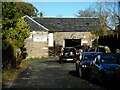
Burnhill Motors
Now a garage, the building was originally a corn mill and dates from 1818. It is Category C listed http://portal.historicenvironment.scot/designation/LB43882.
Image: © Richard Sutcliffe
Taken: 4 Nov 2022
0.03 miles
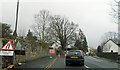
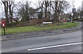
2
A814, Cardross
Looking north. Bainfield House is on the left.
Image: © Richard Sutcliffe
Taken: 4 Nov 2022
0.05 miles
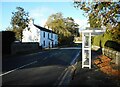
4
The White House
A late 18th-early 19th century house with later 19th century additions. It is situated at the corner of Main Road (A814) and Carman Road. Originally called Bainfield House, this name is now associated with another nearby property Image It is Category C listed http://portal.historicenvironment.scot/designation/LB1153.
Image: © Richard Sutcliffe
Taken: 4 Nov 2022
0.06 miles
6
Craigend Road
Walking down the hill from Walton to Cardross, with a view over the Clyde towards Port Glasgow.
Image: © Barbara Carr
Taken: 18 Apr 2013
0.08 miles
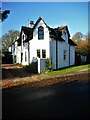
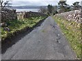
7
Bainfield Road, Cardross
Housing at the southeastern edge of Cardross village.
Image: © Barbara Carr
Taken: 18 Apr 2013
0.08 miles
8
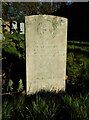
Commonwealth War Grave, Cardross
1472229 GUNNER
W. McMANUS
97TH HEAVY A.A. REGT. R.A.
LONDON SCOTTISH
27TH SEPTEMBER 1941 AGE 19
NEARER MY GOD TO THEE
William McManus, 97 (3rd Battalion, The London Scottish) Heavy Anti-Aircraft, Royal Artillery, was the son of Samuel and Janet McManus, of Cardross.
Image: © Richard Sutcliffe
Taken: 4 Nov 2022
0.08 miles
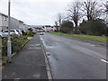
9
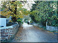
Ferry Road
A dog-walker heads down the road.
Image: © Richard Sutcliffe
Taken: 4 Nov 2022
0.08 miles
10

Cardross old parish Church
Ruin of old Parish Church which was bombed in 1941. The tower remains.
Image: © J M Briscoe
Taken: 7 May 2005
0.09 miles