IMAGES TAKEN NEAR TO
Cedar Grove, DUMBARTON, G82 5JW
Introduction
This page details the photographs taken nearby to Cedar Grove, G82 5JW by members of the Geograph project.
The Geograph project started in 2005 with the aim of publishing, organising and preserving representative images for every square kilometre of Great Britain, Ireland and the Isle of Man.

There are currently over 7.5m images from over14,400 individuals and you can help contribute to the project by visiting https://www.geograph.org.uk
Image Map
Images are licensed for reuse under creativecommons.org/licenses/by-sa/2.0
Notes
- Clicking on the map will re-center to the selected point.
- The higher the marker number, the further away the image location is from the centre of the postcode.
Image Listing (161 Images Found)
Images are licensed for reuse under creativecommons.org/licenses/by-sa/2.0
Image
Details
Distance
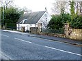
2
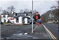
The Coach House Inn, Cardross
Opposite the golf club, on the A814 travelling northwestward to the village centre.
Image: © Barbara Carr
Taken: 18 Apr 2013
0.06 miles
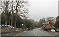
3
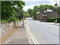
Main road through Cardross
This picture was taken with the Domesday Reloaded project in mind, and was an attempt to recreate an older photograph, which could (at the time) be seen at the BBC's Domesday Reloaded site.
[When I arrived, workmen were working on the road at the exact spot from which the original photograph had been taken. However, they were courteous and helpful, and I was fortunate in that they were due to finish up there for the day shortly after I had arrived.]
Image can be seen in the background. The picture was taken from in front of the club house of Cardross Golf Club. The entrance that is visible not far ahead, on the left, leads to a house called Auchenfroe (after a burn that flows nearby; see below).
The two houses on the right-hand side of the road look much the same as they do in the original photograph. The more distant of the two is called Glenview, and the other is Westburn Cottage. The most noticeable difference in the content of the two pictures, apart from the horse and rider, is the bus stop and shelter. Between the photographer's position and the church in the background, the road crosses the Auchenfroe Burn by means of Image
Image: © Lairich Rig
Taken: 13 May 2011
0.06 miles
4
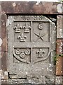
Moore's Bridge - an original stone, with coat of arms
This grey stone was part of a bridge, which, as the date suggests, was built in 1688, and which crossed a burn that still flows here; the stone is now framed within a Victorian restoration of the bridge in red sandstone [see "North Clyde Estuary - An Illustrated Architectural Guide", by Frank Arneil Walker with Fiona Sinclair].
According to one source ["The Church of Cardross and its Ministers" (1935) by Eunice G Murray], the coat of arms is that of the Montgomery family.
Nearby, another original stone, bearing an inscription, has also been preserved as part of the modern bridge; see: Image
Both stones are shown in their context here: Image
Image: © Lairich Rig
Taken: 15 Aug 2007
0.06 miles
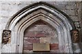
5
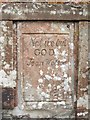
Moore's Bridge - an original stone, with inscription
"Not we but GOD - Jean Watson"
This is one of two stones that were reused from an earlier bridge at this spot. For the other, see Image
The stones are shown in their context at Image Jean Moore, née Watson, was the benefactress of the original (1688) bridge (see the last-cited link for the details).
Image: © Lairich Rig
Taken: 15 Aug 2007
0.06 miles
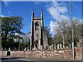
6
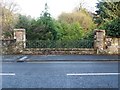
Moore's Bridge
As explained at Image, this is not the original Moore's Bridge, but a Victorian restoration. However, it does incorporate two stones from the original bridge: one is shown at the link just given, while the other is shown here: Image
Both of these stones are visible in this photograph: the inscription is on the left, and the coat of arms is on the right. See also: Image
By 1922, both of those stones had become so worn by the elements as to be almost indecipherable, but the County Council had them cleaned in that year and placed in a higher and more prominent part of the bridge [Eunice G. Murray, "The Church of Cardross and its Ministers" (1935)].
This bridge crosses the rather small Auchenfroe Burn, and only these old stones and the iron railings distinguish what now otherwise looks much the same as the adjacent sections of road. The Auchenfroe Burn is "formed by the union of the Kilmahew and Wallacetown Burns. When it joins the Clyde it is called Cardross Burn" [David Murray, "Old Cardross" (1880); this David Murray was the father of the Eunice G. Murray cited above]. On the naming of the burn here, and on the approach to the shore, see also Image
For the story behind the bridge, see, for example "Cardross: The Village in Days Gone By" (Arthur F. Jones, 1985). As the tale is usually recounted, the young Jean Watson took a piece of meat for her destitute mother from the laird's store, not realizing that it had been set aside for the laird himself. She then fled, but had to stop at the Auchenfroe Burn, which was in spate; she is said to have vowed that, if ever she was able, she would build a bridge over the burn. After she had married a shipbroker named Moore, who subsequently prospered financially, she was able to fulfil her vow.
As the author notes, there are several variations of this story, which has a certain air of legend about it. However, what is beyond question is that a fund (later known as the Moore Mortification Fund) was set up by Jean Moore, née Watson, for the benefit of the poor of the parish who lived between the Auchenfroe Burn and Keppoch. See the work just cited for further details.
Image: © Lairich Rig
Taken: 3 Dec 2008
0.06 miles
8
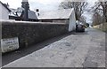
Peel Street, Cardross
Just west of the Coach House Inn, opposite the clubhouse of Cardross Golf Club.
Image: © Barbara Carr
Taken: 18 Apr 2013
0.07 miles