IMAGES TAKEN NEAR TO
Colgrain Steading, DUMBARTON, G82 5JL
Introduction
This page details the photographs taken nearby to Colgrain Steading, G82 5JL by members of the Geograph project.
The Geograph project started in 2005 with the aim of publishing, organising and preserving representative images for every square kilometre of Great Britain, Ireland and the Isle of Man.

There are currently over 7.5m images from over14,400 individuals and you can help contribute to the project by visiting https://www.geograph.org.uk
Image Map
Images are licensed for reuse under creativecommons.org/licenses/by-sa/2.0
Notes
- Clicking on the map will re-center to the selected point.
- The higher the marker number, the further away the image location is from the centre of the postcode.
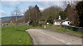
Image Listing (28 Images Found)
Images are licensed for reuse under creativecommons.org/licenses/by-sa/2.0
Image
Details
Distance
2
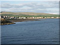
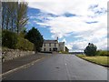
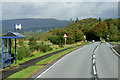
View south-east from Helensburgh pier
The north-eastern shoreline of the river Clyde is in view, along which the road runs south-eastwards towards to Dumbarton.
Image: © Anthony O'Neil
Taken: 31 May 2006
0.04 miles
3
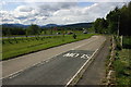
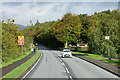
A814 at Colgrain
This is a view looking north along the old section of the A814 at Colgrain, to the left can be seen the new section of the A814.
Image: © George Rankin
Taken: 14 May 2007
0.06 miles
4
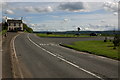
A814 at Colgrain South
Looking south along the old section of the A814 at Colgrain, with the new section of road on the right.
Image: © George Rankin
Taken: 14 May 2007
0.06 miles
6

Old milestone at Colgrain
For a closer look, see Image The present picture is intended only to show it in context.
The stone is shown on OS maps from the second edition (surveyed c.1897) onwards. However, it is identical in appearance to others nearby that were present before 1860, when the first-edition map was surveyed, so its absence from that particular map was probably just an oversight (the nearby stones that are of the same appearance, aside from not having recently been repainted, are Image and Image).
Image: © Lairich Rig
Taken: 6 Jun 2014
0.10 miles
8
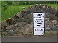
Old Milepost by the A814, near Colgrain Farm, Cardross parish
Dunbarton curved by the A814, in parish of Cardross (Argyll & Bute District), Colgrain, in its own wall South of entrance to Equestrian Centre, West side of road.
Inscription reads:-
{<-hand}
DUNBARTON
CROSS
6.MILES
{diamond}
{hand->}
HELENSBURGH
2.MILES
Surveyed
Milestone Society National ID: AB_DMHL06
Image: © Christine Minto
Taken: 29 May 2009
0.10 miles
9
Milestone at Colgrain, near Helensburgh
This attractive milestone is not mentioned on either the 1:25 000 or 1:50 000 OS maps.
Image: © Becky Williamson
Taken: 7 Apr 2011
0.11 miles
10
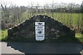
Camis Eskan East Lodge
This was one of three lodges for Camis Eskan House (Image). Mid Lodge is gone (Image), but Image also survives.
Image: © Lairich Rig
Taken: 13 Apr 2012
0.11 miles