IMAGES TAKEN NEAR TO
Perrays Way, DUMBARTON, G82 5HU
Introduction
This page details the photographs taken nearby to Perrays Way, G82 5HU by members of the Geograph project.
The Geograph project started in 2005 with the aim of publishing, organising and preserving representative images for every square kilometre of Great Britain, Ireland and the Isle of Man.

There are currently over 7.5m images from over14,400 individuals and you can help contribute to the project by visiting https://www.geograph.org.uk
Image Map
Images are licensed for reuse under creativecommons.org/licenses/by-sa/2.0
Notes
- Clicking on the map will re-center to the selected point.
- The higher the marker number, the further away the image location is from the centre of the postcode.
Image Listing (42 Images Found)
Images are licensed for reuse under creativecommons.org/licenses/by-sa/2.0
Image
Details
Distance
1
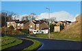
Perrays Drive
The foreground part of the road is in the same grid square as the photographer, but it crosses the grid line about 20 metres before reaching the houses.
The area of housing as a whole is called Lennox Gardens, but the street names are all of a kind — Perrays Drive/Way/Crescent/Court/Grove — referring probably to nearby Image or, with a lesser likelihood, to other Perrays place-names formerly in use; see https://www.geograph.org.uk/snippet/17333 for a detailed discussion of these names.
The small structure to the right of the road, just before the houses, is an electricity sub-station.
Image: © Lairich Rig
Taken: 12 Jan 2020
0.03 miles
2
Perrays Drive
On entering Dumbarton from the direction of Cardross, by means of the main road, this is the first area of housing seen to the north of the road.
See http://www.geograph.org.uk/snippet/17333 on the "Perrays" Name, which was associated with Image long before this housing was built.
Image: © Lairich Rig
Taken: 9 Aug 2013
0.06 miles
3
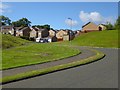
A small roundabout in Lennox Gardens
It is on Image (near right and background left), with Perrays Grove branching off at the near left. The house behind the right-hand edge of the roundabout is on Maple Avenue, a part of Hawthornhill, an area of housing which is adjacent to Lennox Gardens, but distinct from it and separated from it by a fence.
Image: © Lairich Rig
Taken: 12 Jan 2020
0.11 miles
4
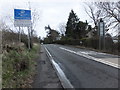
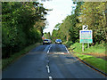
Welcome to West Dunbartonshire
Boundary sign to the west of Dumbarton on the A814.
Image: © Barbara Carr
Taken: 18 Apr 2013
0.11 miles
5
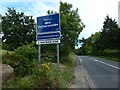
Entering West Dunbartonshire
This sign, with some Gaelic text, replaces the earlier one shown in Image It stands on the line of the Unitary Authority Boundary, as indicated on the OS map.
"Welcome to West Dunbartonshire
Fáilte gu Siorrachd Dhùn Breatann an Iar
A Fairtrade Zone"
Given above as written on the sign: properly, it should have "Fàilte" (I mention this only so that I do not get emails correcting my transcription).
Image: © Lairich Rig
Taken: 29 Aug 2016
0.11 miles
8
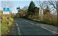
Entering West Dunbartonshire
This is the A814, on the approach to Dumbarton from Cardross, at the boundary of West Dunbartonshire and neighbouring Argyll and Bute.
"Welcome to West Dunbartonshire / West Dunbartonshire and Beauvoisin, France / celebrating friendship / célébration d'amitié"
(The Beauvoisin referred to there is in the Languedoc-Roussillon region.)
The building on the right, almost directly behind the road sign, but only faintly visible through the trees, is Image
By mid-2016, this sign had been replaced by one with different wording: it has English and Gaelic text, and the twinning is no longer mentioned: Image
Image: © Lairich Rig
Taken: 1 Nov 2011
0.12 miles
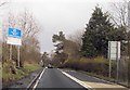
9
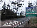
Boundary sign for Argyll and Bute
To the west of Dumbarton on the A814.
Image: © Barbara Carr
Taken: 18 Apr 2013
0.12 miles
10
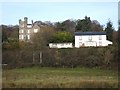
Cats Castle
The tall stone building on the left is called Cats Castle; it was built in 1888 in Scots Baronial style, and is a Category B listed building. For a closer look, see Image
As for its unusual name, the book "North Clyde Estuary - An Illustrated Architectural Guide" (Frank Arneil Walker with Fiona Sinclair) gives an alliterative explanation: "where the old ferry house of Clydebank Farm sits out its retirement (its twin facing on the opposite bank), a Renfrew lawyer built Cats Castle in 1888, its handsome Scots Baronial façades festooned with feline forms".
The photograph was taken from the public footpath that follows the shoreline between Levengrove and Ardoch.
Image: © Lairich Rig
Taken: 21 Nov 2008
0.13 miles