IMAGES TAKEN NEAR TO
Cardross, DUMBARTON, G82 5HE
Introduction
This page details the photographs taken nearby to G82 5HE by members of the Geograph project.
The Geograph project started in 2005 with the aim of publishing, organising and preserving representative images for every square kilometre of Great Britain, Ireland and the Isle of Man.

There are currently over 7.5m images from over14,400 individuals and you can help contribute to the project by visiting https://www.geograph.org.uk
Image Map
Images are licensed for reuse under creativecommons.org/licenses/by-sa/2.0
Notes
- Clicking on the map will re-center to the selected point.
- The higher the marker number, the further away the image location is from the centre of the postcode.
Image Listing (66 Images Found)
Images are licensed for reuse under creativecommons.org/licenses/by-sa/2.0
Image
Details
Distance
2
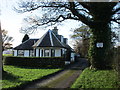
Ardmore House, East Lodge
A Category C listed building [http://portal.historicenvironment.scot/designation/LB1160] close to the shore.
Image: © Richard Sutcliffe
Taken: 3 Feb 2019
0.01 miles
3
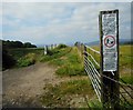
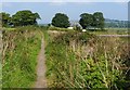
Notices at the start of the path
Two notices at the start of the path round Ardmore Point. One asks dog walkers to keep dogs on leads; the other is in relation to the Coronavirus (Covid-19) pandemic and tells people to keep to the paths, not to enter fields, not to feed or touch any animals or farm gates.
Image: © Richard Sutcliffe
Taken: 13 Aug 2020
0.03 miles
4
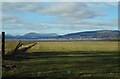
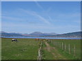
Field, Ardmore Point
Helensburgh is in the distance.
Image: © Richard Sutcliffe
Taken: 1 Mar 2023
0.04 miles
5
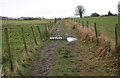
Footpath around Ardmore Point
This footpath follows the top of the beach, and leads right around the end of the peninsula. As noted in Image, other sections of the path can be very muddy underfoot (almost always so in winter, and after wet weather at any time of year).
The building visible at the end of the path is Ardmore Gate Lodge.
Image: © Lairich Rig
Taken: 3 Sep 2010
0.05 miles
6
Nature trail at Ardmore Point, Dunbartonshire
Looking towards Helensburgh
Image: © Brian D Osborne
Taken: 29 Apr 2006
0.06 miles
7
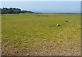
Ardmore Point
The most prominent part of the peninsula of Ardmore Point is a wooded area centred on the Image; in the present photograph, that area is located at the far left.
However, as the photo also shows, the strip of land connecting the Hill of Ardmore to the main body of the shoreline between Cardross and Helensburgh is fairly low and flat. The wooded hill at the centre of Ardmore Point was once an island, and is surrounded by what were once sea cliffs, and a raised beach.
Image: © Lairich Rig
Taken: 3 Sep 2010
0.08 miles
8
Footpath, Ardmore Point
The pallet is in use to cross a wet and muddy patch.
Image: © Richard Sutcliffe
Taken: 3 Feb 2019
0.08 miles
9
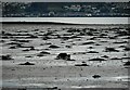
Spot the dog
A collie pretends to be a pile of seaweed, while stalking its master, who is walking along the shore.
Image: © Richard Sutcliffe
Taken: 1 Mar 2023
0.09 miles
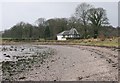
10
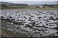
Seaweed on the shore
Many clumps of seaweed visible at low tide. The building on the other side of the beach is Ardmore Farm.
Image: © Richard Sutcliffe
Taken: 3 Feb 2019
0.09 miles