IMAGES TAKEN NEAR TO
Main Road, DUMBARTON, G82 5BT
Introduction
This page details the photographs taken nearby to Main Road, G82 5BT by members of the Geograph project.
The Geograph project started in 2005 with the aim of publishing, organising and preserving representative images for every square kilometre of Great Britain, Ireland and the Isle of Man.

There are currently over 7.5m images from over14,400 individuals and you can help contribute to the project by visiting https://www.geograph.org.uk
Image Map
Images are licensed for reuse under creativecommons.org/licenses/by-sa/2.0
Notes
- Clicking on the map will re-center to the selected point.
- The higher the marker number, the further away the image location is from the centre of the postcode.
Image Listing (91 Images Found)
Images are licensed for reuse under creativecommons.org/licenses/by-sa/2.0
Image
Details
Distance
2
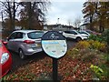
Interpretation panel at Cardross
This is the point where Park Terrace branches off from the Main Road. The panel is, like the one shown in Image, associated with the Clyde Sea Lochs Trail. This one is about the village of Cardross.
Image: © Lairich Rig
Taken: 11 Nov 2016
0.01 miles
3
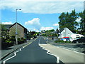
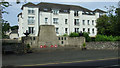
Main Road, Cardross
Cardross (Scottish Gaelic: Càrdainn Ros) is a large village on the north side of the Firth of Clyde, situated halfway between Dumbarton and Helensburgh.
Image: © David Dixon
Taken: 26 Sep 2019
0.02 miles
4
Main Street, Cardross
The A814 through Cardross.
Image: © Barbara Carr
Taken: 18 Apr 2013
0.05 miles
5

Cardross War Memorial
See Image for another view.
Image: © Lairich Rig
Taken: 1 Feb 2013
0.07 miles
6
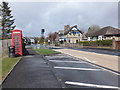
Cardross War Memorial
On Main Road at Station Road.
Image: © Thomas Nugent
Taken: 12 Jul 2013
0.07 miles
7
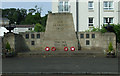
Cardross War Memorial
On Main Road at Station Road.
Image: © Thomas Nugent
Taken: 12 Jul 2013
0.07 miles
8
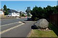
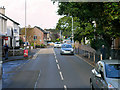
Main Road through Cardross
For the large stone and the plaque on it, see Image, a view in the opposite direction.
Image: © Lairich Rig
Taken: 13 Jul 2018
0.07 miles
9
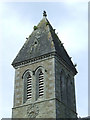
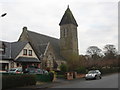
Cardross Parish Church tower
A Category B Listed building http://data.historic-scotland.gov.uk/pls/htmldb/f?p=2200:15:0::::BUILDING:42917 on Station Road. See also Image
Image: © Thomas Nugent
Taken: 12 Jul 2013
0.07 miles
10
Cardross Parish Church
Former Free Kirk. For more details see Image]
Image: © James Denham
Taken: 24 Nov 2013
0.07 miles