IMAGES TAKEN NEAR TO
Carrick Terrace, DUMBARTON, G82 5BF
Introduction
This page details the photographs taken nearby to Carrick Terrace, G82 5BF by members of the Geograph project.
The Geograph project started in 2005 with the aim of publishing, organising and preserving representative images for every square kilometre of Great Britain, Ireland and the Isle of Man.

There are currently over 7.5m images from over14,400 individuals and you can help contribute to the project by visiting https://www.geograph.org.uk
Image Map
Images are licensed for reuse under creativecommons.org/licenses/by-sa/2.0
Notes
- Clicking on the map will re-center to the selected point.
- The higher the marker number, the further away the image location is from the centre of the postcode.
Image Listing (61 Images Found)
Images are licensed for reuse under creativecommons.org/licenses/by-sa/2.0
Image
Details
Distance
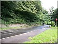
1
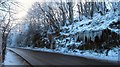
Renton Road
Icicles are a regular winter feature of the overhang beside the road. The course of the Renton road follows the line of what is said to be a raised beach, as is well exemplified at this particular section.
Image: © Lairich Rig
Taken: 24 Dec 2010
0.10 miles
2
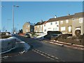
Castlehill Road
This part of Dumbarton is called Castlehill. The photograph was taken at the junction with Image
For details of the Castle Hill after which the area is named, see Image
Image: © Lairich Rig
Taken: 24 Dec 2010
0.12 miles
3
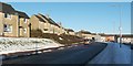
Hawthornhill Road, Castlehill
This is the eastern end of Hawthornhill Road; the junction with Castlehill Road is not far ahead (just beyond the two cars). The houses in the right-hand half of the image are on the latter road.
For a view in the opposite direction along the same part of the road, see Image
For other sections, see Image and Image
Image: © Lairich Rig
Taken: 24 Dec 2010
0.13 miles
4
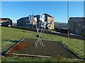
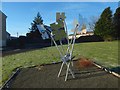
Castlehill sculpture: "Making our Mark"
The street in the background is Cumbrae Crescent North.
The sculpture is shown from another angle in Image Information about it is etched onto its reflective surfaces.
Image: © Lairich Rig
Taken: 8 Jan 2018
0.15 miles
5
Castlehill sculpture: "Making our Mark"
"A creative project by young people from Castlehill", as the text etched onto this jigsaw-puzzle-themed sculpture says. It stands beside the junction of Cumbrae Crescent North and Castlehill Road. See Image for a view from a different angle.
Image: © Lairich Rig
Taken: 8 Jan 2018
0.15 miles
6

View from railway bridge
This is the view to the north as seen from the railway bridge that is discussed at Image
Image: © Lairich Rig
Taken: 10 Aug 2009
0.16 miles
7
Junction of A812 with the A82(T) sliproad at Dalmoak
Image: © Elliott Simpson
Taken: 7 Aug 2017
0.17 miles
8
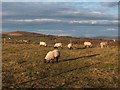
Knowetop Farm, Castlehill, Dumbarton
Sheep grazing at Knowetop Community Farm, Castlehill, Dumbarton. The snow-clad summit of Ben Lomond can just be seen on the centre horizon.
Image: © Andrew McEwan
Taken: 27 Nov 2005
0.17 miles
9
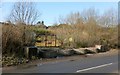
Dalreoch Quarry
The entrance to this disused quarry is on the Image
Dalreoch Quarry appears to be one and the same as the Jamesheid Quarry that is referred to in a 1609 charter by James VI. The identification is made, though not explicitly, on page 97 of local historian Donald MacLeod's "Dumbarton, Vale of Leven, and Loch Lomond" (1884). There, the author describes a walk from Dumbarton to the Vale of Leven. From his description, it is clear that he was following the Image, and he writes that "when the auld toon o' Dumbarton, in our journey Renton-wards, was left half a mile or so in our rear, we passed the centuries-old quarry of Jamesheid, from which the stones were taken to build the brig o' Dumbarton". This can only be a reference to what was later called Dalreoch Quarry; there is no other in the area.
The 1609 charter already mentioned runs to great length, but the relevant portion relates to the "water works" (the flood defences against the River Leven – see Image), and grants to the Provost, Bailies and Councillors of Dumbarton the right "to dig stones in the common quarry called Jamesheid lying within our property of the lands of the lordship of Cardross, to cast turf there, with power to transport the said stones and turf by the better way to the said work through any part of the foresaid lands without any impediment to be made to them by us or any person whatsoever". The text of the charter as quoted here is from the second volume of Joseph Irving's "Book of Dumbartonshire" (1879), and has clearly been modernised by the author. Note also that in 1609, when the charter was made, the quarry was within Cardross Parish: see Image
In 1719, the embankment at the Broadmeadow that served as flood defences against the River Leven were seriously damaged; see Image for a discussion of the "Drowned Lands". Stone was to be taken from this quarry to repair the defenses. As described in the second volume of Joseph Irving's "Book of Dumbartonshire" (1879):
"In the early part of 1719, the embankments on the Broad Meadow were seriously damaged by storms and floods; and for the purpose of having them put into proper repair, the Provost suggested that a tax of two pennies Scots might be levied upon the pint of such ale as was brewed and consumed in the burgh. The resolution, or some one equivalent thereto, appears to have been adopted, as in October the necessary 'quarry graith', or quarrying implements, is ordered to be prepared for taking stones from Jameshead(*) quarry to the works then being carried on at the Meadow."
Amongst the structures that have been built using stone from Dalreoch Quarry are Image, Image, and Image
The disused quarry is now designated a "Locally Important SINC" (Site of Importance for Nature Conservation).
- - • - -
(*) One otherwise excellent modern reference work on the archaeological potential of the burgh of Dumbarton says that stone was to be taken from "Jamestown Quarry" in order to effect these repairs; as support for this, it cites the passage from Irving, just quoted.
However, the name given in Irving's book is Jameshead quarry. The authors may have been mislead by the similarity of the names Jameshead and Jamestown, and they perhaps had in mind Image, which is near Jamestown. Such a misidentification is understandable, since, so far as I am aware, no older authors have explicitly identified Jameshead Quarry with Dalreoch Quarry; it has to be inferred indirectly. Whether the authors of the modern reference work had that in mind or not, their mention of Jamestown Quarry might cause confusion, so it is worth saying a little more here about the identity of the quarry.
The quarry at Bonhill can be ruled out, since the 1609 charter says that Jamesheid quarry is in the lands of Cardross. Although the boundaries of Cardross Parish changed after the 1609 charter was written, Bonhill had not previously been, and is not now, in that parish. As an aside, it is also worth noting that there was no settlement near Bonhill with the name of Jamestown (Image) until much later.
Since the identification of Jameshead Quarry with Dalreoch Quarry has had to be inferred from comments by Donald MacLeod, it is also worth adding that MacLeod (Image) was a friend of Joseph Irving (Image), and viewed him as his "literary father"; if there had been any doubt about which quarry Irving had in mind when he wrote about "Jameshead Quarry", MacLeod would have been well placed to find out.
Finally, Dr David Murray, in his "Old Cardross: A Lecture" (1880), includes an appendix of Cardross place-names (i.e., places that were in the old parish of Cardross; some of that land is now in Dumbarton). The appendix includes the following terse but useful entry: "Jamesheid Quarry – near Dumbarton".
Another old quarry not far from this one was Kirkton Quarry, which is now long disused, its site occupied by Image However, there is little danger of confusion with respect to that quarry, since it is referred to as "Kirkton Quarry" from a very early period; see the burgh records quoted at Image
Image: © Lairich Rig
Taken: 18 Feb 2013
0.18 miles
10
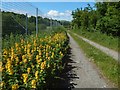
Dotted Loosestrife beside a path
As can be seen on the 1:25000 map, a road branches off from the Renton Road and leads to the premises of Image and to Image The path shown in the present picture leads from that road to the footpath along the western side of the River Leven. The map also shows that this stretch of the path runs alongside the railway line.
The plant is Image, which, for some reason, is often confused with Yellow Loosestrife. The genuine Yellow Loosestrife looks quite different: Image / Image
Image: © Lairich Rig
Taken: 12 Jun 2018
0.18 miles