IMAGES TAKEN NEAR TO
Cumbrae Crescent South, DUMBARTON, G82 5AP
Introduction
This page details the photographs taken nearby to Cumbrae Crescent South, G82 5AP by members of the Geograph project.
The Geograph project started in 2005 with the aim of publishing, organising and preserving representative images for every square kilometre of Great Britain, Ireland and the Isle of Man.

There are currently over 7.5m images from over14,400 individuals and you can help contribute to the project by visiting https://www.geograph.org.uk
Image Map
Images are licensed for reuse under creativecommons.org/licenses/by-sa/2.0
Notes
- Clicking on the map will re-center to the selected point.
- The higher the marker number, the further away the image location is from the centre of the postcode.
Image Listing (68 Images Found)
Images are licensed for reuse under creativecommons.org/licenses/by-sa/2.0
Image
Details
Distance
1
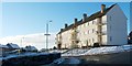
Cumbrae Crescent South, Castlehill
This is the eastern end of the road; for the other end, see Image
The present photograph was taken from the junction with Image On the other side of Castlehill Road (in other words, behind the photographer's position), the continuation of Cumbrae Crescent South is called Cumbrae Crescent North (the latter is shorter, only a third of the length of the southern section).
Image: © Lairich Rig
Taken: 24 Dec 2010
0.02 miles
2

Castlehill Road
For more on the road, and on the Castlehill area, see Image
At the junction that is visible ahead, Castlehill Road continues to the left, towards Image; Knowetop Crescent branches off to the right.
Image: © Lairich Rig
Taken: 24 Dec 2010
0.05 miles
3
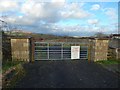
Gate at former site of Knowetop Community Farm
There was no sign, from here, of the community farm buildings that had until recently occupied the site. As I confirmed not long afterwards, they had been cleared away: see Image and Image
Image: © Lairich Rig
Taken: 29 Dec 2015
0.06 miles
4
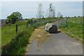
Path from Castlehill Road
It meets up with the Hawthornhill-to-Dalmoak route — https://www.geograph.org.uk/snippet/4594 — but is not part of it. See Image for a view back to the gate from further ahead.
Image: © Lairich Rig
Taken: 29 May 2020
0.07 miles
5
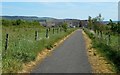
Path to Castlehill Road
The houses not far ahead, where the path ends, are on Castlehill Road. For a view back from there, see Image
Image: © Lairich Rig
Taken: 29 May 2020
0.07 miles
6
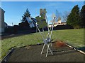
Castlehill sculpture: "Making our Mark"
"A creative project by young people from Castlehill", as the text etched onto this jigsaw-puzzle-themed sculpture says. It stands beside the junction of Cumbrae Crescent North and Castlehill Road. See Image for a view from a different angle.
Image: © Lairich Rig
Taken: 8 Jan 2018
0.07 miles
7
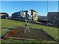
Castlehill sculpture: "Making our Mark"
The street in the background is Cumbrae Crescent North.
The sculpture is shown from another angle in Image Information about it is etched onto its reflective surfaces.
Image: © Lairich Rig
Taken: 8 Jan 2018
0.07 miles
8
Hawthornhill Road, Castlehill
This part of the road is just to the north of Image and Image (see also Image).
For other parts of the road, see Image and Image
Image: © Lairich Rig
Taken: 24 Dec 2010
0.07 miles
9
Path near Knowetop Farm
Image itself has now closed. The houses visible ahead are at the top of Castlehill. The path, if followed in the opposite direction, meets a Image
The two peaks of Dumbarton Rock are visible at the far right.
Image: © Lairich Rig
Taken: 28 Sep 2013
0.07 miles
10
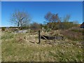
Former site of Knowetop Community Farm
This part was the garden; earlier pictures show how it looked before the community farm was cleared away: Image / Image
Image: © Lairich Rig
Taken: 20 Apr 2016
0.07 miles