IMAGES TAKEN NEAR TO
Main Street, DUMBARTON, G82 4QA
Introduction
This page details the photographs taken nearby to Main Street, G82 4QA by members of the Geograph project.
The Geograph project started in 2005 with the aim of publishing, organising and preserving representative images for every square kilometre of Great Britain, Ireland and the Isle of Man.

There are currently over 7.5m images from over14,400 individuals and you can help contribute to the project by visiting https://www.geograph.org.uk
Image Map
Images are licensed for reuse under creativecommons.org/licenses/by-sa/2.0
Notes
- Clicking on the map will re-center to the selected point.
- The higher the marker number, the further away the image location is from the centre of the postcode.
Image Listing (96 Images Found)
Images are licensed for reuse under creativecommons.org/licenses/by-sa/2.0
Image
Details
Distance
1
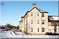
Main Street, Renton
The photograph was taken from the top of Image, and is a view along the buildings on Main Street.
Note the wall just to the left of the road. The name Main Street applies not just to the road beside which these buildings stand, on the near side of the wall, but also to the main road for traffic; that road is on the other side of the wall, and runs in the same direction.
Image: © Lairich Rig
Taken: 29 Nov 2010
0.03 miles
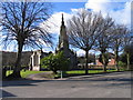
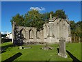
2
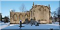
Millburn Church
This is a side view of the church that is shown from the front in Image (where the spire is intact) and in Image See Image for another view.
At the time this picture was submitted, the category A listed building was being left to go to ruin. The listed building report cited in the end-note provides further details, and the book cited there gives more details about the building's early history, and the succession of ministers.
The same work notes that, before the kirkyard was provided at Millburn, the people of Renton had been buried in the graveyard of the Relief Church (later U.P.); at West Bridgend in Dumbarton; in Bonhill churchyard; or in the parish churchyard at Cardross.
Image: © Lairich Rig
Taken: 29 Nov 2010
0.04 miles
3
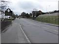
Approaching Renton on the B857
Travelling southwards into Renton.
Image: © Barbara Carr
Taken: 21 Apr 2013
0.05 miles
5
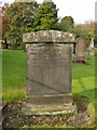
Millburn Kirkyard: Meikleham/Colquhoun Memorial
There are no very old stones in this kirkyard, since the church itself dates only from about 1845, but this is one of the older stones. It is located on the northern side of Image
"Erected by Robert Meikleham, Portioner in Renton, in memory of his wife Isabella Colquhoun, who died January 24th 1851, in the 72nd year of her age. Also, his grandchildren: Agness Nicolson, who died March 5th 1854, aged 2 years; Isabella Nicolson, who died March 11th 1854, aged 4 years. Robert Meikleham died May 17th 1860, in his 81st year."
Portioner: owner of a small estate or piece of land that was formerly part of a larger estate (in other words, the larger estate has been split up and portioned out).
Image: © Lairich Rig
Taken: 22 Oct 2012
0.05 miles
6
Millburn Church Renton
Millburn Church Renton
Image: © Eddie Mackinnon
Taken: 4 Apr 2006
0.05 miles
7
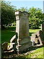
The gravestone of Matthew Turnbull
This is one of two stones in this kirkyard that mark the resting place of nieces of Highland Mary; for the other, see Image
The gravestone of Matthew Turnbull is located in the part of the kirkyard of Image that lies to the north of the ruined church. For another view of the church, see Image An earlier view shows it intact: Image
The inscription notes that Matthew Turnbull died on the 13th of November 1891, aged 85, and that he had been Manager of Cordale until 1859. This is a reference to the Cordale Print Works, which were located on Cordale Point; see Image
The inscription also mentions "Ann Anderson, his beloved wife, who died 11th January 1859 aged 51 years"; she was a niece of Highland Mary, for whom see the Image For more details on this topic, see Image
As for the Turnbull family named here, they were remembered in the name of Turnbull's Loan ("Trummel's Loan" in speech; see Image). Maps now call that road Place of Bonhill, but that was properly the name of the family's home; see Image
Donald MacLeod, in his "Historic Families ... of the Lennox" (1891), devotes a couple of pages to their history. He writes that they originally came from Bedrule (Image) in Roxburghshire, but that they moved to Lanarkshire where they were tacksmen of Blantyre Farm. MacLeod cites a document, dated 1654, which states that a certain James Turnbull was a tenant of the farm at that time. From about 1750 onwards, some of the Turnbulls established themselves as wood merchants in Govan, and then as Calico printers at Dawsholm. It was at the latter location that they became associated with the firm of William Stirling & Sons; that business association would continue here alongside the River Leven.
Image: © Lairich Rig
Taken: 7 Aug 2012
0.05 miles
8
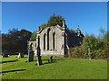
Millburn Church
Comparison with an earlier picture, Image, in which the spire is shown intact, reveals that the present photograph was taken from close to the edge of the kirkyard, near the main road. Click on the end-note title for related pictures.
Image: © Lairich Rig
Taken: 2 Oct 2016
0.05 miles
9
Millburn Church
For a similar view in snow, see Image An older view, Image, shows the spire intact. Click on the end-note title for other pictures.
Image: © Lairich Rig
Taken: 2 Oct 2016
0.05 miles
10
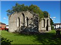
Millburn Church
For a similar view in snow, see Image An older view, Image, shows the spire intact. Click on the end-note title for other pictures.
Image: © Lairich Rig
Taken: 2 Oct 2016
0.05 miles