IMAGES TAKEN NEAR TO
Tontine Crescent, DUMBARTON, G82 4LN
Introduction
This page details the photographs taken nearby to Tontine Crescent, G82 4LN by members of the Geograph project.
The Geograph project started in 2005 with the aim of publishing, organising and preserving representative images for every square kilometre of Great Britain, Ireland and the Isle of Man.

There are currently over 7.5m images from over14,400 individuals and you can help contribute to the project by visiting https://www.geograph.org.uk
Image Map
Images are licensed for reuse under creativecommons.org/licenses/by-sa/2.0
Notes
- Clicking on the map will re-center to the selected point.
- The higher the marker number, the further away the image location is from the centre of the postcode.
Image Listing (128 Images Found)
Images are licensed for reuse under creativecommons.org/licenses/by-sa/2.0
Image
Details
Distance
1
Canary Shouldered Thorn (Ennomos alniaria)
This specimen was attracted to my lighted window. http://www.habitas.org.uk/moths/species.asp?item=6004
Image: © Stan Campbell
Taken: 3 Sep 2008
0.04 miles
2
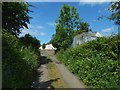
The western end of the Howgate
Behind the hedge on the left, and at a slightly higher level than the path, is the original site of Renton War Memorial: Image See Image for its current location.
To the right of the path are an electricity sub-station and houses in the Tontine Park area.
Image: © Lairich Rig
Taken: 5 Jun 2018
0.04 miles
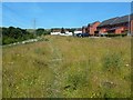
3
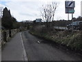
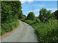
Track alongside the A812
South of Renton.
Image: © Barbara Carr
Taken: 21 Apr 2013
0.05 miles

6
Taylor Street, Dalquhurn
The picture was taken in connection with the Geograph article linked from the end-note, in which I present my research into the location of Pillanflatt Farm, which appears to have been in existence in 1841, but which had disappeared completely when the first OS map of the area was surveyed in 1860.
The two western buildings were located, roughly, in the area between the vehicles (cars and vans) and the two brick-red buildings to their right (north). The annotated satellite view that is also linked from the end-note makes this clear.
For a view in the opposite direction from about that spot, see Image, which explains where the farm's eastern building, probably the farmhouse, was located in relation to present-day features.
The houses here were built in around 2011. The white buildings in the background of the present picture are not part of the same development, but are older houses in the Tontine Park area of Renton.
Image: © Lairich Rig
Taken: 27 Jun 2018
0.06 miles
7

The former site of farm buildings at Pillanflatt
A farm called Pillanflatt disappeared before the earliest OS maps of the area were surveyed, but it does appear on an 1841 plan. My map-based research on its location is presented in an article that is linked from the end-note.
According to that research, the two western buildings at Pillanflatt, as depicted on the 1841 plan, were more or less where the modern-day houses are in the left foreground of this photograph.
See Image for the site of the main farmhouse itself. Both of these sites are on present-day Taylor Street in a recently built housing development at Dalquhurn.
See the article for a full discussion. See also the annotated satellite view that is linked from the end-note; these sites are marked on it.
Image: © Lairich Rig
Taken: 13 Jul 2018
0.06 miles
8
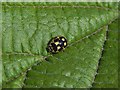
14-Spot Ladybird
(Propylea 14-punctata)
See http://www.coleoptera.org.uk/species/propylea-quattuordecimpunctata (at UK Beetle Recording) for details. As the distribution map there makes clear, this species is not common here in Scotland (though it should be taken into account that such maps reflect the distribution, not just of species but, to some extent, of people who are interested in observing and recording them). The name is properly Propylea quattuordecimpunctata (with the number spelled out), but, as with other ladybird species, a less cumbersome form employing digits is often used.
Not all ladybirds of this species show the same degree of spot fusion as the one in my picture; put simply, this one has more black and less yellow than many others. The base colour also varies a little: sometimes paler, sometimes more orange.
This one was on the shoot of a young tree in a small patch of woodland near a road junction that is marked on the map.
See Image for an earlier picture of this species by another contributor.
Image: © Lairich Rig
Taken: 4 Sep 2018
0.06 miles

10
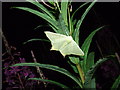
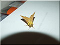
Swallow-tailed Moth
One of our more attractive moths Ourapterix sambucaria feeds at Buddleias Umbellifers Rosebay willowherb flowers on warm July nights http://ukmoths.org.uk/show.php?bf=1922
Image: © Stan Campbell
Taken: 7 Jul 2008
0.06 miles