IMAGES TAKEN NEAR TO
Woodvale, Lennox Street, DUMBARTON, G82 4LH
Introduction
This page details the photographs taken nearby to Woodvale, Lennox Street, G82 4LH by members of the Geograph project.
The Geograph project started in 2005 with the aim of publishing, organising and preserving representative images for every square kilometre of Great Britain, Ireland and the Isle of Man.

There are currently over 7.5m images from over14,400 individuals and you can help contribute to the project by visiting https://www.geograph.org.uk
Image Map
Images are licensed for reuse under creativecommons.org/licenses/by-sa/2.0
Notes
- Clicking on the map will re-center to the selected point.
- The higher the marker number, the further away the image location is from the centre of the postcode.
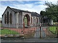
Image Listing (175 Images Found)
Images are licensed for reuse under creativecommons.org/licenses/by-sa/2.0
Image
Details
Distance
1
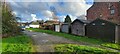
Lock-ups at Tontine Crescent, Renton
Lock-ups at Tontine Crescent, Renton. Just off Main Street.
Image: © coughlan
Taken: 6 Nov 2022
0.02 miles
2
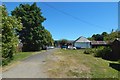
The line of an old road in Renton
This path leads from the main road (at this end) to a point near the junction of John Street and Alexander Street.
The path may now seem insignificant, but it is the relic of a road that followed precisely this line, and which considerably pre-dates the other streets in the area (of the adjacent present-day streets, only the main road itself is older).
Back when it was a road, the path shown here used to continue further in this direction; it led to Dalquhurn House, Dalquhurn Cottage, and the River Leven.
When the first-edition OS map was surveyed in 1860, this road was then present, but the nearest buildings to the north were in the vicinity of the present-day leisure centre: Image The continuous, built-up part of Renton did not yet extend this far to the south.
The small white building shown right of centre in the present picture, with bins on its near side, is now a private house, but I remember it being a doctor's clinic several decades ago.
Image: © Lairich Rig
Taken: 30 Jun 2018
0.03 miles
3
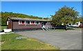
Pavilion in Wylie Park
Or Tontine Park; it is properly Wylie Park, but the other name seems to be used at least as often these days. I don't have an issue with that usage myself; I mention it here (and in the end-note), for my usual reason: to give a more rounded view, rather than wanting to be didactic.
There is a plaque on this side, beside the entrance: Image
The links given in the end-note, referring to the Vale of Leven website (always a good and well-informed source) have more on both parks.
Image: © Lairich Rig
Taken: 6 May 2020
0.03 miles
4
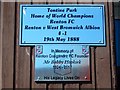
Plaque on a pavilion
See Image for the building in context. The plaque is on that side, just to the left of the entrance.
Image: © Lairich Rig
Taken: 6 May 2020
0.03 miles
5

Lock-ups at Tontine Crescent, Renton
Just off Main Street
Image: © coughlan
Taken: 27 Oct 2012
0.03 miles
6
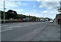
Renton Road
The B857 looking north.
Image: © Richard Sutcliffe
Taken: 28 Jul 2023
0.04 miles
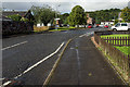
8
Tontine Park
Residential street in Renton.
Image: © Richard Sutcliffe
Taken: 28 Jul 2023
0.04 miles
9
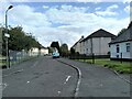
John Street Renton
John Street Renton looking south
Image: © Eddie Mackinnon
Taken: 20 May 2007
0.05 miles
10
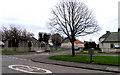
Hall beside John Street and Tontine Park
See Image for Lairich Rig's description of the hall.
Image: © Richard Sutcliffe
Taken: 28 Jul 2023
0.05 miles