IMAGES TAKEN NEAR TO
Cardross Road, DUMBARTON, G82 4JD
Introduction
This page details the photographs taken nearby to Cardross Road, G82 4JD by members of the Geograph project.
The Geograph project started in 2005 with the aim of publishing, organising and preserving representative images for every square kilometre of Great Britain, Ireland and the Isle of Man.

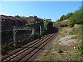
There are currently over 7.5m images from over14,400 individuals and you can help contribute to the project by visiting https://www.geograph.org.uk
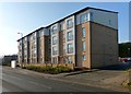
Image Map
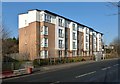
Images are licensed for reuse under creativecommons.org/licenses/by-sa/2.0
Notes
- Clicking on the map will re-center to the selected point.
- The higher the marker number, the further away the image location is from the centre of the postcode.
Image Listing (86 Images Found)
Images are licensed for reuse under creativecommons.org/licenses/by-sa/2.0
Image
Details
Distance
1
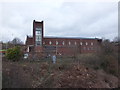
St Michael's Roman Catholic Church, Dumbarton
See http://www.stmichael.rcglasgow.org.uk/ourchurch
Image: © Barbara Carr
Taken: 18 Apr 2013
0.03 miles
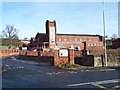
3
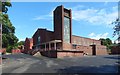
St Michael's RC Church
Image: © Lairich Rig
Taken: 3 Aug 2020
0.04 miles
4
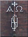
St Michael's RC Church: detail
Alpha and Omega, and an IHS monogram. For the whole building, see Image, which has links to other contributors' earlier pictures.
Image: © Lairich Rig
Taken: 3 Aug 2020
0.04 miles
5
The railway line at Dalreoch
The viewpoint (at the side of the Renton Road) is very close to the OS grid line; compare Image
Image: © Lairich Rig
Taken: 25 Apr 2020
0.08 miles
6
Flats by the Renton Road
They were built sometime between 2005 and 2010. They are shown from a different angle, on the same day, in Image
Image: © Lairich Rig
Taken: 18 Feb 2013
0.08 miles
7
Flats by the Renton Road
As the map shows, the railway line passes under the road at about the point from which the picture was taken. The building is shown from a different angle, on the same day, in Image
Image: © Lairich Rig
Taken: 18 Feb 2013
0.08 miles
8
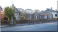
Bruce's Stables
These buildings are called Bruce's Stables, and are named after King Robert I (Robert the Bruce), in whose honour a commemorative flagstaff stands nearby (Image).
Robert the Bruce has no real connection with these buildings, which date from a much later period; according to the book "North Clyde Estuary - An Illustrated Architectural Guide" (Frank Arneil Walker with Fiona Sinclair), they date from the late-eighteenth century, and were designed by Charles Ross for Easter Hole, which was later known as Braehead Farm(*). As the book also mentions, there used to be three cottages here; only two of them remain.
[(*) See also Image]
The same architect, Charles Ross of Greenlaw (near Paisley), also designed the so-called Girnin' Gates (now demolished) which stood at the southern entrance of Garscadden House in Drumchapel.
Although apparently self-taught, Ross was, as well as an architect, an amateur archaeologist and nurseryman (he established a nursery at Greenlaw, and the estate plans which he drew up often contained suggestions for agricultural improvement); he was also a cartographer and land surveyor who made significant contributions to the mapping of Renfrewshire and other parts of Scotland in the second half of the eighteenth century. His map of the county of Renfrew (1754) was one of the earliest separately-published county maps of Scotland.
Image: © Lairich Rig
Taken: 29 Dec 2008
0.09 miles
9
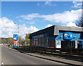
A814 approaching A812 at Dennystown
Image: © Elliott Simpson
Taken: 30 Apr 2016
0.09 miles
10
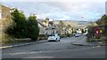
Charlotte Street
This street is in the Oxhill area of Dumbarton. The point from which this picture was taken is shown in Image; that item also explains why the area is called Oxhill.
In the present photograph, the distant background is taken up by Image, with the housing estate of Bellsmyre laid out in front of them.
Image: © Lairich Rig
Taken: 1 Feb 2013
0.10 miles