IMAGES TAKEN NEAR TO
Comelybank Lane, DUMBARTON, G82 4JA
Introduction
This page details the photographs taken nearby to Comelybank Lane, G82 4JA by members of the Geograph project.
The Geograph project started in 2005 with the aim of publishing, organising and preserving representative images for every square kilometre of Great Britain, Ireland and the Isle of Man.

There are currently over 7.5m images from over14,400 individuals and you can help contribute to the project by visiting https://www.geograph.org.uk
Image Map
Images are licensed for reuse under creativecommons.org/licenses/by-sa/2.0
Notes
- Clicking on the map will re-center to the selected point.
- The higher the marker number, the further away the image location is from the centre of the postcode.
Image Listing (107 Images Found)
Images are licensed for reuse under creativecommons.org/licenses/by-sa/2.0
Image
Details
Distance
1
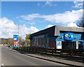
A814 approaching A812 at Dennystown
Image: © Elliott Simpson
Taken: 30 Apr 2016
0.04 miles
2
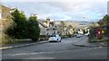
Charlotte Street
This street is in the Oxhill area of Dumbarton. The point from which this picture was taken is shown in Image; that item also explains why the area is called Oxhill.
In the present photograph, the distant background is taken up by Image, with the housing estate of Bellsmyre laid out in front of them.
Image: © Lairich Rig
Taken: 1 Feb 2013
0.04 miles
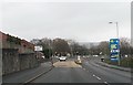
4
The former site of Dalreoch Toll
The picture shows the junction of Cardross Road / Glasgow Road (in the foreground) and Renton Road (background, right). The building at the centre of the picture is more or less on the site of Dalreoch Toll. The tollhouse was still standing at the start of the twentieth century, although there had been no tolls on public roads since 1883 [see page 87 of I M M MacPhail's "Dumbarton through the Centuries" (1972)].
The tollhouse is the squat building that can be seen in the foreground of Alexander Kellock Brown's painting "Dumbarton in Glassmaking Days", shown at http://artuk.org/discover/artworks/dumbarton-in-glassmaking-days-194878 (at ArtUK). It can also been seen in two very similar paintings by I Clark: see http://artuk.org/discover/artworks/dumbarton-in-glassmaking-days-194883 (also at ArtUK).
These paintings also show the three cones of the glassworks (see Image), Image, and Image
Examination of the 25-inch OS map published in 1919 shows tramlines passing Dalreoch Toll (the tollhouse was then still standing). If the tramlines were still present today, they would be seen entering this photograph where the cars are stopped, and they would leave the picture at the lower right corner.
Followed north from here, the line passed Image, already disused by then, on the way to Renton. Followed in the opposite direction, the line passed through the West Bridgend area of Dumbarton, crossed Image, and then followed the town's High Street. In the vicinity of Image, the line divided, with one branch continuing along Image (the lines visible in that picture are unrelated to the trams), and the other turning off to follow Church Street (Image) and then Strathleven Place. Further information about these routes, and about the history of trams in this area, can be found in the booklet "Dumbarton's Trams and Buses" (A W Brotchie and R L Grieves, 1985).
Compare Image, which had also been the site of one of the burgh's tollhouses, and which was also the end-point of one of the town's tramlines.
Image: © Lairich Rig
Taken: 18 Feb 2013
0.07 miles
5
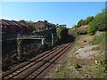
The railway line at Dalreoch
The viewpoint (at the side of the Renton Road) is very close to the OS grid line; compare Image
Image: © Lairich Rig
Taken: 25 Apr 2020
0.07 miles
6
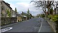
Oxhill Road
The same road is shown, viewed in the opposite direction, in Image; see that link for the origins of the name Oxhill, which applies to this area as well as to the road.
The foreground area of both pictures is the same, though viewed in opposite directions (for example, the same lamp post appears in the foreground of both pictures, and the same figure "20" painted on the road). The present picture was taken from a point opposite the junction with Image
Image: © Lairich Rig
Taken: 1 Feb 2013
0.07 miles
7
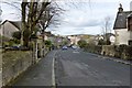
Oxhill Road
This area of Dumbarton is called Oxhill, after the Oxen Hill that is depicted here on the first-edition OS map, which was surveyed in 1860. Oxen Hill was described in the OS Object Name Books (compiled in the 1890s) as "a small arable hill on the farm of Braehead". On the second-edition OS map (c.1898), it was called Ox Hill.
Oxen Hill or Ox Hill was at Image, and Braehead (formerly Easter Hole*) is shown on the maps at Image, just to the south of the main road; those buildings are now known as Braehead Cottages, or as Image
For a view in the opposite direction, see Image In the present view, the junction with Image can be seen on the right, almost opposite the blue car.
[(*) W.C.Maugham, in his "Annals of Garelochside" (1897), on page 263, while aware that Easter Hole was simply another name for Foul Hole, seems to treat that farm as separate from Braehead: "Easter Hole or Foul Hole and Braehead succeed, with Sandybraes, Castlehill, and Muirhouses fronting them" (note "them"). However, other printed reference works treat Braehead as a later name for Easter/Foul Hole; compare, for example, "North Clyde Estuary: An Illustrated Architectural Guide" (F.A.Walker & F.Sinclair, 1992), on the so-called Bruce's Stables, "built for Easter Hole, later Braehead Farm".]
Image: © Lairich Rig
Taken: 1 Feb 2013
0.07 miles
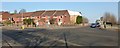
8
Housing near Dalreoch Station
In west Dumbarton.
Image: © Stephen Sweeney
Taken: 25 Nov 2007
0.08 miles
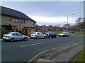
9
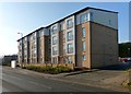
Flats by the Renton Road
They were built sometime between 2005 and 2010. They are shown from a different angle, on the same day, in Image
Image: © Lairich Rig
Taken: 18 Feb 2013
0.09 miles
10
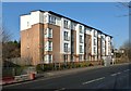
Flats by the Renton Road
As the map shows, the railway line passes under the road at about the point from which the picture was taken. The building is shown from a different angle, on the same day, in Image
Image: © Lairich Rig
Taken: 18 Feb 2013
0.09 miles