IMAGES TAKEN NEAR TO
Graham Road, DUMBARTON, G82 4EH
Introduction
This page details the photographs taken nearby to Graham Road, G82 4EH by members of the Geograph project.
The Geograph project started in 2005 with the aim of publishing, organising and preserving representative images for every square kilometre of Great Britain, Ireland and the Isle of Man.

There are currently over 7.5m images from over14,400 individuals and you can help contribute to the project by visiting https://www.geograph.org.uk
Image Map
Images are licensed for reuse under creativecommons.org/licenses/by-sa/2.0
Notes
- Clicking on the map will re-center to the selected point.
- The higher the marker number, the further away the image location is from the centre of the postcode.
Image Listing (50 Images Found)
Images are licensed for reuse under creativecommons.org/licenses/by-sa/2.0
Image
Details
Distance
1
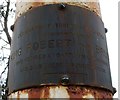
Plaque on Bruce's Flagstaff
The plaque is of brass, and was very dark from weathering (the contrast with its much brighter surroundings made it a difficult subject for photography). The date at the lower right is not all visible, but reads "23rd June 1928". The position of the plaque can be discerned on the right-hand side of the flagstaff, near the base, in Image
At the time when the flagstaff was erected in 1928, the popular opinion was that King Robert the Bruce had spent his final years at nearby Image This would soon be disputed; the article linked from the end-note discusses these matters in much greater detail.
It is now generally considered that the Bruce's residence was elsewhere (again, see the article), but the flagstaff itself remains a fitting memorial to the King's association with the wider area.
The present picture was taken in 2012. By November 2018, when the picture was submitted, the plaque was no longer present; for that reason, it seemed worth showing here, as a record of something that is now gone. The reason the plaque is gone is that flagstaff itself had by that time been (recently) replaced by a new one. The new flagstaff was octagonal in cross-section throughout its height and, unlike the original, was not spliced.
Image: © Lairich Rig
Taken: 13 Apr 2012
0.10 miles
3
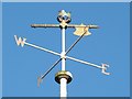
Bruce's Flagstaff: detail
This weather vane, incorporating a battle axe and crown, tops Image at the foot of Brucehill, near Castle Hill (a knoll that gives the Castlehill area its name).
See Image for the same weather vane in 2018, on the replacement flagstaff.
Image: © Lairich Rig
Taken: 29 Dec 2008
0.10 miles
4
Bruce's Flagstaff
This flagstaff, near Image, was erected in 1928 to honour King Robert the Bruce. See Image for the top of it.
The name Castle Hill, and the presence of a mound which, at that time, was thought to be the remnant of a once fortified site, suggested that it was the probable location of the residence at which the king had spent much time in his later years (see Image for another view of that hill). The 1928 flagstaff was erected by the Dumbarton Patriotic Association; their plaque on the flagstaff is shown in Image, and promoted the idea that the king had lived at Castle Hill.
[The present photograph was taken from Glencairn Road. The main road running from left to right across the image, behind the flagstaff, is Cardross Road; from that road, Castlehill Road leads uphill. The area on the near side of Cardross Road is now called Brucehill, and the area on the far side of the road is called Castlehill. However, the "Castle Hill" referred to above is the actual hill of that name, which is at Image, hidden away in the wooded north-eastern corner of what is now the Image]
[As an aside, the nearby Oxhill area is named after Oxen Hill, "a small arable hill on the farm of Braehead"; the hill and farm are shown on the first-edition OS map, and the quote is from the OS Object Name Books.]
Although current thinking would place Bruce's house elsewhere (as discussed at length in the article linked from the end-note), the flagstaff remains a fitting symbol of Robert the Bruce's historical associations with the wider area.
By late 2018, the flagstaff had been replaced by a new one: Image / Image The symbolic weather vane remained: Image The plaque, since its text applies only to the *original* flagstaff, is no longer present.
The article in the end-note also has more information about the flagstaff itself.
Image: © Lairich Rig
Taken: 29 Dec 2008
0.10 miles
5
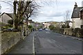
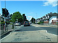
Oxhill Road
This area of Dumbarton is called Oxhill, after the Oxen Hill that is depicted here on the first-edition OS map, which was surveyed in 1860. Oxen Hill was described in the OS Object Name Books (compiled in the 1890s) as "a small arable hill on the farm of Braehead". On the second-edition OS map (c.1898), it was called Ox Hill.
Oxen Hill or Ox Hill was at Image, and Braehead (formerly Easter Hole*) is shown on the maps at Image, just to the south of the main road; those buildings are now known as Braehead Cottages, or as Image
For a view in the opposite direction, see Image In the present view, the junction with Image can be seen on the right, almost opposite the blue car.
[(*) W.C.Maugham, in his "Annals of Garelochside" (1897), on page 263, while aware that Easter Hole was simply another name for Foul Hole, seems to treat that farm as separate from Braehead: "Easter Hole or Foul Hole and Braehead succeed, with Sandybraes, Castlehill, and Muirhouses fronting them" (note "them"). However, other printed reference works treat Braehead as a later name for Easter/Foul Hole; compare, for example, "North Clyde Estuary: An Illustrated Architectural Guide" (F.A.Walker & F.Sinclair, 1992), on the so-called Bruce's Stables, "built for Easter Hole, later Braehead Farm".]
Image: © Lairich Rig
Taken: 1 Feb 2013
0.10 miles
6
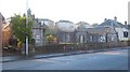
Bruce's Stables
These buildings are called Bruce's Stables, and are named after King Robert I (Robert the Bruce), in whose honour a commemorative flagstaff stands nearby (Image).
Robert the Bruce has no real connection with these buildings, which date from a much later period; according to the book "North Clyde Estuary - An Illustrated Architectural Guide" (Frank Arneil Walker with Fiona Sinclair), they date from the late-eighteenth century, and were designed by Charles Ross for Easter Hole, which was later known as Braehead Farm(*). As the book also mentions, there used to be three cottages here; only two of them remain.
[(*) See also Image]
The same architect, Charles Ross of Greenlaw (near Paisley), also designed the so-called Girnin' Gates (now demolished) which stood at the southern entrance of Garscadden House in Drumchapel.
Although apparently self-taught, Ross was, as well as an architect, an amateur archaeologist and nurseryman (he established a nursery at Greenlaw, and the estate plans which he drew up often contained suggestions for agricultural improvement); he was also a cartographer and land surveyor who made significant contributions to the mapping of Renfrewshire and other parts of Scotland in the second half of the eighteenth century. His map of the county of Renfrew (1754) was one of the earliest separately-published county maps of Scotland.
Image: © Lairich Rig
Taken: 29 Dec 2008
0.10 miles
7
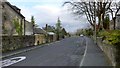
Oxhill Road
The same road is shown, viewed in the opposite direction, in Image; see that link for the origins of the name Oxhill, which applies to this area as well as to the road.
The foreground area of both pictures is the same, though viewed in opposite directions (for example, the same lamp post appears in the foreground of both pictures, and the same figure "20" painted on the road). The present picture was taken from a point opposite the junction with Image
Image: © Lairich Rig
Taken: 1 Feb 2013
0.10 miles
8
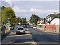
Pedestrian Traffic Lights on Cardross Road, Dumbarton
Image: © David Dixon
Taken: 26 Sep 2019
0.10 miles
9
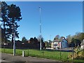
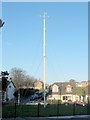
Bruce's Flagstaff
This is not the 1928 original (Image), erected by the Dumbarton Patriotic Association, but is its replacement, which, as far as I know, had only recently been erected when this picture was taken. See Image for a view from another angle.
The replacement flagstaff has a different cross-section, and is not spliced. It is, though, topped by the same symbolic weather vane, with battle axe and crown: Image
It lacks the plaque that the original one bore: Image Note that the idea expressed on that plaque about the location of Robert the Bruce's Cardross residence is no longer in favour; the article linked from the end-note discusses these matters in detail.
Image: © Lairich Rig
Taken: 27 Oct 2018
0.10 miles
10
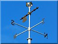
Bruce's flagstaff: detail
The crown and battle axe are as in an earlier picture, Image, though with some repainting, but the flagstaff itself had been replaced in the meantime. The present picture shows the weather vane on the replacement flagstaff, present in late 2018: Image / Image
The original one (erected by the Dumbarton Patriotic Association in 1928) is shown in Image
Image: © Lairich Rig
Taken: 8 Nov 2018
0.10 miles