IMAGES TAKEN NEAR TO
Glencairn Road, DUMBARTON, G82 4DL
Introduction
This page details the photographs taken nearby to Glencairn Road, G82 4DL by members of the Geograph project.
The Geograph project started in 2005 with the aim of publishing, organising and preserving representative images for every square kilometre of Great Britain, Ireland and the Isle of Man.

There are currently over 7.5m images from over14,400 individuals and you can help contribute to the project by visiting https://www.geograph.org.uk
Image Map
Images are licensed for reuse under creativecommons.org/licenses/by-sa/2.0
Notes
- Clicking on the map will re-center to the selected point.
- The higher the marker number, the further away the image location is from the centre of the postcode.
Image Listing (53 Images Found)
Images are licensed for reuse under creativecommons.org/licenses/by-sa/2.0
Image
Details
Distance
1
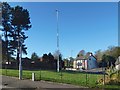
Bruce's Flagstaff
This is not the 1928 original (Image), erected by the Dumbarton Patriotic Association, but is its replacement, which, as far as I know, had only recently been erected when this picture was taken. See Image for a view from another angle.
The replacement flagstaff has a different cross-section, and is not spliced. It is, though, topped by the same symbolic weather vane, with battle axe and crown: Image
It lacks the plaque that the original one bore: Image Note that the idea expressed on that plaque about the location of Robert the Bruce's Cardross residence is no longer in favour; the article linked from the end-note discusses these matters in detail.
Image: © Lairich Rig
Taken: 27 Oct 2018
0.14 miles
2
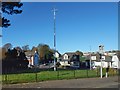
Bruce's Flagstaff
This is not the original one (Image), which was erected in 1928, and which was spliced partway up; this is its replacement. However, the symbolic weather vane, with crown and battle axe, is still present: Image
The view is across Brucehill Road. Cardross Road runs left to right behind the flagstaff, and Castlehill Road leads uphill behind it. See Image for a view from another angle.
Image: © Lairich Rig
Taken: 27 Oct 2018
0.14 miles
3

Bruce's flagstaff: detail
The crown and battle axe are as in an earlier picture, Image, though with some repainting, but the flagstaff itself had been replaced in the meantime. The present picture shows the weather vane on the replacement flagstaff, present in late 2018: Image / Image
The original one (erected by the Dumbarton Patriotic Association in 1928) is shown in Image
Image: © Lairich Rig
Taken: 8 Nov 2018
0.14 miles
5

Bruce's Flagstaff: detail
This weather vane, incorporating a battle axe and crown, tops Image at the foot of Brucehill, near Castle Hill (a knoll that gives the Castlehill area its name).
See Image for the same weather vane in 2018, on the replacement flagstaff.
Image: © Lairich Rig
Taken: 29 Dec 2008
0.15 miles
6
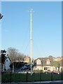
Bruce's Flagstaff
This flagstaff, near Image, was erected in 1928 to honour King Robert the Bruce. See Image for the top of it.
The name Castle Hill, and the presence of a mound which, at that time, was thought to be the remnant of a once fortified site, suggested that it was the probable location of the residence at which the king had spent much time in his later years (see Image for another view of that hill). The 1928 flagstaff was erected by the Dumbarton Patriotic Association; their plaque on the flagstaff is shown in Image, and promoted the idea that the king had lived at Castle Hill.
[The present photograph was taken from Glencairn Road. The main road running from left to right across the image, behind the flagstaff, is Cardross Road; from that road, Castlehill Road leads uphill. The area on the near side of Cardross Road is now called Brucehill, and the area on the far side of the road is called Castlehill. However, the "Castle Hill" referred to above is the actual hill of that name, which is at Image, hidden away in the wooded north-eastern corner of what is now the Image]
[As an aside, the nearby Oxhill area is named after Oxen Hill, "a small arable hill on the farm of Braehead"; the hill and farm are shown on the first-edition OS map, and the quote is from the OS Object Name Books.]
Although current thinking would place Bruce's house elsewhere (as discussed at length in the article linked from the end-note), the flagstaff remains a fitting symbol of Robert the Bruce's historical associations with the wider area.
By late 2018, the flagstaff had been replaced by a new one: Image / Image The symbolic weather vane remained: Image The plaque, since its text applies only to the *original* flagstaff, is no longer present.
The article in the end-note also has more information about the flagstaff itself.
Image: © Lairich Rig
Taken: 29 Dec 2008
0.15 miles
7
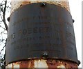
Plaque on Bruce's Flagstaff
The plaque is of brass, and was very dark from weathering (the contrast with its much brighter surroundings made it a difficult subject for photography). The date at the lower right is not all visible, but reads "23rd June 1928". The position of the plaque can be discerned on the right-hand side of the flagstaff, near the base, in Image
At the time when the flagstaff was erected in 1928, the popular opinion was that King Robert the Bruce had spent his final years at nearby Image This would soon be disputed; the article linked from the end-note discusses these matters in much greater detail.
It is now generally considered that the Bruce's residence was elsewhere (again, see the article), but the flagstaff itself remains a fitting memorial to the King's association with the wider area.
The present picture was taken in 2012. By November 2018, when the picture was submitted, the plaque was no longer present; for that reason, it seemed worth showing here, as a record of something that is now gone. The reason the plaque is gone is that flagstaff itself had by that time been (recently) replaced by a new one. The new flagstaff was octagonal in cross-section throughout its height and, unlike the original, was not spliced.
Image: © Lairich Rig
Taken: 13 Apr 2012
0.15 miles
8
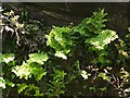
Royal Fern colony
The ferns are growing high up on Brucehill Cliffs, which are part of a Local Nature Conservation Site; see Image for details (and for the context).
The work that is cited there notes that the cliffs, which are of red sandstone, "are almost constantly wet, and the dripping water sustains an interesting floral community, most notably the locally rare royal fern – the largest colony in West Dunbartonshire. The ferns are rooted directly into the cliff faces."
In "A Natural History of Britain's Ferns" (1988), Christopher N. Page devotes a section to "Cliff-face Royal Fern Communities"; he notes there that where the Royal Fern (Osmunda regalis) "is present in cliffside habitats it usually occurs mainly as very numerous but mostly juvenile plants ... Only occasional plants have fertile fronds ...", and he mentions that, although sometimes the ferns occur singly at such sites, "where the spread of run-off water creates fairly large areas of permanently damp rock, quite dense colonies with numerous plants may occur".
That description fits this environment very well; no fertile fronds were apparent when I took this photograph (contrast Image and Image, where some typically narrow, upright, brownish fertile fronds can be seen in the centre of the clumps).
Page also notes that acidic, peaty run-off water can provide a suitable cliffside habitat for Osmunda regalis (Royal Fern), while lime-rich run-off is suitable for Adiantum capillus-veneris (Maidenhair Fern).
Image: © Lairich Rig
Taken: 1 Jul 2011
0.17 miles
9
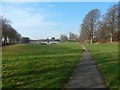
Cunninghame Graham Memorial Park
The view is as in the earlier Image, but without the snow or the recently-demolished Image; see Image
The wooded knoll called Image is at the far right; the smaller knoll that is to its left, a little further away, is Image See the end-note for more on these.
Image: © Lairich Rig
Taken: 27 Feb 2019
0.18 miles
10
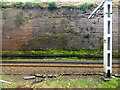
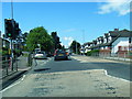
Railway cutting at Dumbarton tunnels
The line is cut through red sandstone on the approach to the tunnels from the west. Viewed from and east bound train.
Image: © Thomas Nugent
Taken: 13 Apr 2016
0.19 miles