IMAGES TAKEN NEAR TO
Bowie Street, DUMBARTON, G82 4BJ
Introduction
This page details the photographs taken nearby to Bowie Street, G82 4BJ by members of the Geograph project.
The Geograph project started in 2005 with the aim of publishing, organising and preserving representative images for every square kilometre of Great Britain, Ireland and the Isle of Man.

There are currently over 7.5m images from over14,400 individuals and you can help contribute to the project by visiting https://www.geograph.org.uk
Image Map
Images are licensed for reuse under creativecommons.org/licenses/by-sa/2.0
Notes
- Clicking on the map will re-center to the selected point.
- The higher the marker number, the further away the image location is from the centre of the postcode.
Image Listing (279 Images Found)
Images are licensed for reuse under creativecommons.org/licenses/by-sa/2.0
Image
Details
Distance
1
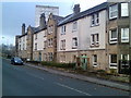
Tenements in Dumbarton
On West Bridgend.
Image: © Stephen Sweeney
Taken: 25 Nov 2007
0.02 miles
2
Cycle Path at Dalreoch
Cycle Path at Dalreoch from Old Dumbarton Bridge looking North
Image: © Eddie Mackinnon
Taken: 24 May 2007
0.02 miles
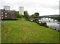
3
Benches by the River Leven
A relaxing place to sit, and good restbite on the Glasgow-Loch Lomond cycleway.
Image: © Stephen Sweeney
Taken: 25 Nov 2007
0.02 miles
4
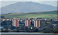
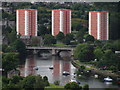
Dumbarton towerblocks
Viewed across the River Clyde from Golf Road, Bishopton.
See them from a different angle Image
Image: © Thomas Nugent
Taken: 16 Apr 2018
0.03 miles
5
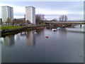
River Leven and Dumbarton high rise flats
From the Bridge Street bridge.
Image: © Stephen Sweeney
Taken: 25 Nov 2007
0.04 miles
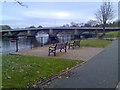
6
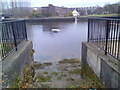
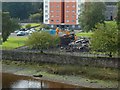
Access point to the River Leven
By the look of the condition of the area, it is no longer used.
Image: © Stephen Sweeney
Taken: 25 Nov 2007
0.04 miles
7
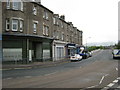
West Bridgend Dumbarton
View towards Old Dumbarton Bridge with West Bridgend shops in foreground.
Image: © Eddie Mackinnon
Taken: 24 May 2007
0.05 miles
8
View from Dumbarton Rock towards Dumbarton Bridge & Clyde & Lomond Courts
Image: © Colin Park
Taken: 6 Jun 2012
0.05 miles
10
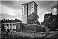
Demolition of West Bridgend Community Centre
The view is from Image For more context, see Image
In the present view, the rubble from the community centre is directly in front of Clyde Court, one of Image
For a view of the demolition site from another angle, and for further information, see Image
Image: © Lairich Rig
Taken: 26 Sep 2017
0.05 miles