IMAGES TAKEN NEAR TO
Woodyard Road, DUMBARTON, G82 4BH
Introduction
This page details the photographs taken nearby to Woodyard Road, G82 4BH by members of the Geograph project.
The Geograph project started in 2005 with the aim of publishing, organising and preserving representative images for every square kilometre of Great Britain, Ireland and the Isle of Man.

There are currently over 7.5m images from over14,400 individuals and you can help contribute to the project by visiting https://www.geograph.org.uk
Image Map (Loading...)


Getting Data...Please wait
Leaflet Map data © OpenStreetMap
Images are licensed for reuse under creativecommons.org/licenses/by-sa/2.0
Notes
- Clicking on the map will re-center to the selected point.
- The higher the marker number, the further away the image location is from the centre of the postcode.
Image Listing (361 Images Found)
Images are licensed for reuse under creativecommons.org/licenses/by-sa/2.0
Image
Details
Distance
1
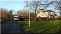
Woodyard Road, Dumbarton
The building on the right is Image The road and the house take their name from the Woodyard, a shipbuilding yard that used to be located here; see the last-cited link for further details.
See Image for a different section of the road.
Image: © Lairich Rig
Taken: 13 Jan 2012
0.03 miles
2
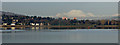
Dumbarton and Ben Lomond
Viewed from a Glasgow bound train near Langbank.
Image: © Thomas Nugent
Taken: 7 Jan 2018
0.03 miles
3
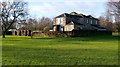
Woodyard House
The house was formerly part of a shipbuilding yard, the Woodyard. In the early days of Dumbarton's shipbuilding industry, Archibald McLachlan was based here, building wooden ships, such as the steamer "Trusty" (1814) – see Image and http://www.geograph.org.uk/article/Dumbarton-Cemetery#shipbuilding-and-other-industries for more information.
The yard is now long gone, but the name of Image, alongside which the house stands, commemorates it.
In the 1880s, this house was very much in the heart of the shipbuilding yard; there was a machine shop next to the house, on the north-eastern side, and a larger machine shop at the north-western side. In addition, there was a smithy at the south-eastern side of the house.
See also Image (taken from roughly the same area as the present photograph).
Image: © Lairich Rig
Taken: 13 Jan 2012
0.04 miles
4
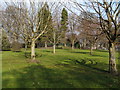
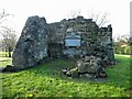
The enclosure of St Serf's Church
The small fenced enclosure at the centre of the photograph contains Image For a more distant view of this area, see Image
Image: © Lairich Rig
Taken: 2 Mar 2011
0.05 miles
5
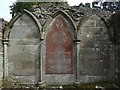
St Serf's Church: Dixons' Memorial Tablet
For a view in context, showing this tablet at the eastern end-wall of the ruin, see Image For more detail about the ruin itself, see Image
The tablet commemorates members of the Dixon family, of Dumbarton Glassworks. It features the Dixon Crest and the motto "Fortes Fortuna Juvat", and it is dated 1885, though it features additions down to 1916.
See http://www.geograph.org.uk/article/Dumbarton-Cemetery#st-serfs-church (from one of my articles), which mentions that the Dixons, who acquired the Levengrove Estate early in the nineteenth century, ploughed up the ancient burial ground here, so that only a couple of the older stones survive. They then used the ruin of St Serf's as their own family mausoleum.
As well as the tablet shown in the present picture of the eastern gable, note the mortar shapes in the lower halves of the empty spaces to either side; I take these to be traces of other modifications that were made in the nineteenth century in order to make this ruin into a family mausoleum.
Long ago, this was the parish church of Cardross, with a cluster of buildings beside it (the clachan of Little Kirkton or Under Kirkton). A plaque is on the north side of the ruin: Image
Image: © Lairich Rig
Taken: 27 Aug 2017
0.05 miles
6
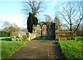
St Serf's Church
Ruins of St Serf's Church, in Levengrove Park. It is first mentioned in a charter of 1226 as the Parish Church of Cardross. It remained in use until 1644. The ruins underwent restoration funded by an Ancient Monuments Grant in 2018. It is a Scheduled Monument http://portal.historicenvironment.scot/designation/SM9654.
Image: © Richard Sutcliffe
Taken: 19 Nov 2022
0.05 miles
7
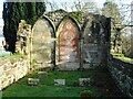
St Serf's Church
Ruins of St Serf's Church, in Levengrove Park. It is first mentioned in a charter of 1226 as the Parish Church of Cardross. It remained in use until 1644. The ruins underwent restoration funded by an Ancient Monuments Grant in 2018. It is a Scheduled Monument http://portal.historicenvironment.scot/designation/SM9654.
Image: © Richard Sutcliffe
Taken: 19 Nov 2022
0.05 miles
8
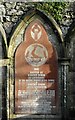
Memorial to Robert Dixon and his family
Erected in 1885 within the remains of St Surf's Church in Levengrove Park. See Image for more information.
Image: © Richard Sutcliffe
Taken: 19 Nov 2022
0.05 miles
9
St Serf's Church
The remains of the chancel of St Serf's Church, in Levengrove Park. It is first mentioned in a charter of 1226 as the Parish Church of Cardross. It remained in use until 1644. The ruins underwent restoration funded by an Ancient Monuments Grant in 2018. It is a Scheduled Monument http://portal.historicenvironment.scot/designation/SM9654.
The memorial on the wall is in memory of Robert Dixon of Levengrove (1856-1912).
Image: © Richard Sutcliffe
Taken: 19 Nov 2022
0.05 miles
10
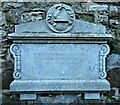
In Memory of Robert Dixon
Located within the ruins of the chancel of St Serf's Church Image
FORTES FORTUNA JUVAT
IN MEMORY OF
ROBERT DIXON OF LEVENGROVE
BORN 28TH FEBRUARY 1856
DIED 15TH JULY 1912
Image: © Richard Sutcliffe
Taken: 19 Nov 2022
0.05 miles