IMAGES TAKEN NEAR TO
Stirling Road, DUMBARTON, G82 3RG
Introduction
This page details the photographs taken nearby to Stirling Road, G82 3RG by members of the Geograph project.
The Geograph project started in 2005 with the aim of publishing, organising and preserving representative images for every square kilometre of Great Britain, Ireland and the Isle of Man.

There are currently over 7.5m images from over14,400 individuals and you can help contribute to the project by visiting https://www.geograph.org.uk
Image Map
Images are licensed for reuse under creativecommons.org/licenses/by-sa/2.0
Notes
- Clicking on the map will re-center to the selected point.
- The higher the marker number, the further away the image location is from the centre of the postcode.
Image Listing (72 Images Found)
Images are licensed for reuse under creativecommons.org/licenses/by-sa/2.0
Image
Details
Distance
2

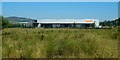
Aggreko manufacturing plant
The building straddles the OS grid line. I have used its centre for the subject location.
Image: © Lairich Rig
Taken: 8 Aug 2020
0.01 miles
3

Aggreko manufacturing plant
This is one of a series of images showing various stages of construction of the new manufacturing plant. In the present image, the building appears to be externally complete. Click on the title of the end-note for other views.
The new facility was officially opened by Princess Anne on the 25th of April 2012; see Image, unveiled on the same day.
Image: © Lairich Rig
Taken: 1 Feb 2012
0.02 miles
4

Manufacturing plant under construction
Aggreko's new manufacturing plant is to be in operation by 2012. When this photograph was taken, the exterior of the building looked to be complete, but construction was still taking place inside.
Click on the title of the end-note for other views of the construction process.
Image: © Lairich Rig
Taken: 6 Nov 2011
0.02 miles
5

Manufacturing plant under construction
The picture was taken from the other side of Stirling Road. Click on the title of the end-note for other views of the construction process.
The building at the extreme right is a bottling and blending plant, also shown in Image and Image
Image: © Lairich Rig
Taken: 2 Dec 2010
0.02 miles
6

Manufacturing plant under construction
This is one of a series of pictures showing various stages in the construction of Aggreko's new manufacturing plant at Kilmalid. Click on the title of the end-note for other stages of construction.
The present picture was taken from near Image
Image: © Lairich Rig
Taken: 15 Feb 2011
0.02 miles
7

Bladder Campion
(Silene vulgaris)
The Image has a wild flower area in its grass verge, on the side facing Stirling Road: Image
This flower caught my eye as I passed; presumably it simply happened to be in the seeds used to sow the wild flower patch. However, it was the only example of this species in evidence at the time.
Image: © Lairich Rig
Taken: 16 Jun 2020
0.04 miles
8
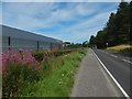
Wild flower verge beside the Aggreko plant
It extends part of the way along the side of the Image that faces Stirling Road. Compare Image, taken here.
Image: © Lairich Rig
Taken: 9 Aug 2020
0.05 miles
9
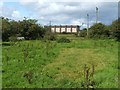
Hut base associated with WWII gun emplacements
The item of interest here is the lighter area of short grass in the foreground; the grass is shorter there because it is growing in thin soil on top of a concrete hut base.
Here, at NS 40029 77040, the outline of the hut base is quite clear. About 20 metres to the east and to the west of this one, there are similar remains which show some fragments of concrete, but which reveal the overall outline rather less clearly.
The large building in the background is a bottling plant (Image) at Kilmalid.
Image: © Lairich Rig
Taken: 28 Aug 2009
0.08 miles
10

Aggreko manufacturing plant
The subject matter here is the area on the near side of the building itself, currently including a car park.
When this picture was taken, there was an Aggreko site here at Kilmalid, and another in the Broadmeadow Industrial Estate, Dumbarton. The two facilities were to be consolidated onto the Kilmalid site. The extension to accommodate the currently Broadmeadow-based operations here will replace what is now the car park; a replacement car park will be created further to the south.
That new car park will extend into the area shown on the left, currently outside the fence. The picture was framed in what might otherwise seem a lopsided manner in order to include that area. Later pictures show work taking place there: Image / Image
Image: © Lairich Rig
Taken: 6 Sep 2020
0.08 miles