IMAGES TAKEN NEAR TO
Macphie Road, DUMBARTON, G82 3PZ
Introduction
This page details the photographs taken nearby to Macphie Road, G82 3PZ by members of the Geograph project.
The Geograph project started in 2005 with the aim of publishing, organising and preserving representative images for every square kilometre of Great Britain, Ireland and the Isle of Man.

There are currently over 7.5m images from over14,400 individuals and you can help contribute to the project by visiting https://www.geograph.org.uk
Image Map
Images are licensed for reuse under creativecommons.org/licenses/by-sa/2.0
Notes
- Clicking on the map will re-center to the selected point.
- The higher the marker number, the further away the image location is from the centre of the postcode.
Image Listing (85 Images Found)
Images are licensed for reuse under creativecommons.org/licenses/by-sa/2.0
Image
Details
Distance
1
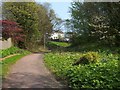
Path to Overtoun Estate
This photograph was taken just a little further along the path that is shown in Image; see that item for further information.
Visible not far ahead, in the present photograph, are the backs of some of the houses on Image There is an extensive patch of Butterbur on the right; the leaves are much larger when fully grown.
This path is a remnant of an Image that was built in the nineteenth century.
Image: © Lairich Rig
Taken: 19 Apr 2011
0.05 miles
2
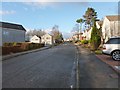
Campbell Avenue, High Overtoun
Campbell Avenue, viewed here from its north-western end, is the highest of the streets in the High Overtoun area of Dumbarton; it is one street above Image
The picture was taken from Image; specifically, from the corner that is visible in that photograph.
300 metres further along Campbell Avenue is one of the entrances to the estate surrounding Overtoun House: Image See also Image, a view of the street from there.
Image: © Lairich Rig
Taken: 2 Dec 2010
0.06 miles
3
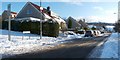
MacPhie Road, High Overtoun
High Overtoun is an area of Dumbarton. This photograph was taken from the junction with Garshake Road.
Image: © Lairich Rig
Taken: 2 Dec 2010
0.06 miles
4
Path to Overtoun Estate
The view is similar to Image, taken earlier in the year (though a different year); note the large Butterbur leaves to the right of the path.
Image: © Lairich Rig
Taken: 29 Jun 2018
0.06 miles
5
Campbell Avenue, High Overtoun
See Image for further details. The present view is in the opposite direction; the picture was taken from near an entrance to the Overtoun Estate (Image).
Image: © Lairich Rig
Taken: 7 Dec 2012
0.06 miles
6

Looking down Garshake Road
The photo was taken from the top of the road; see: Image
For comments on the history and meaning of the name Garshake, see Image
Image: © Lairich Rig
Taken: 22 Oct 2008
0.08 miles
7
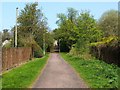
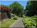
Path to Overtoun Estate
This path is a remnant of an Image that was built in the nineteenth century.
The path leads from Image to one of the entrances of the present-day Overtoun Estate (Image), and forms part of two circular walks, namely, The Crags Circular Path and Overtoun House Circular Path.
For a view from further along the path, see Image
Image: © Lairich Rig
Taken: 19 Apr 2011
0.08 miles
8

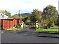
The top of Garshake Road
This is the top of Garshake Road, which is seen entering at the lower edge of photo, and which leads steeply uphill towards this point; see: Image
The road turning off to the right is Image The other road, in the left of the photo, leads to a waterworks (Image); the notice alongside it is a prohibition against fly-tipping, warning that the area is covered by CCTV.
The top of the road is also the starting point for a core path that leads to Square Wood. Use the "Next" link, below, to see the next part of the route.
Next: Image
Image: © Lairich Rig
Taken: 22 Oct 2008
0.09 miles
9
Pedestrian access to Overtoun Estate
This entrance is located on Image The path through these gates (see Image) leads to Image
The fact that Campbell Avenue now cuts across the route disguises the fact that the road on the far side of the gate, and the path that leads uphill to the gate (Image), were originally a single Image The avenue was built in the nineteenth century; it began at a lodge beside the main road (Image), and led uphill, crossing Image to arrive at Image
Image: © Lairich Rig
Taken: 22 Oct 2008
0.10 miles
10
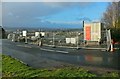
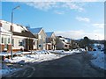
New Dumbarton Cemetery under construction
This is the upper end of the construction site; there will be an entrance here. Click on the end-note title for related pictures.
The present image is a view from the junction of Garshake Road (visible in the picture) and Campbell Avenue (Image).
Image: © Lairich Rig
Taken: 2 Jan 2015
0.10 miles